| PalestineRemembered | About Us | Oral History | العربية | |
| Pictures | Zionist FAQs | Haavara | Maps | |
| Search |
| Camps |
| Districts |
| Acre |
| Baysan |
| Beersheba |
| Bethlehem |
| Gaza |
| Haifa |
| Hebron |
| Jaffa |
| Jericho |
| Jerusalem |
| Jinin |
| Nablus |
| Nazareth |
| Ramallah |
| al-Ramla |
| Safad |
| Tiberias |
| Tulkarm |
| Donate |
| Contact |
| Profile |
| Videos |
Welcome To al-Khalasa - الخلصة
|
District of Beersheba
Ethnically cleansed days ago |
العربية Google Earth |
 |
Gallery (39) |
- Statistics & Facts
- Satellite View
- Articles 1
- Pictures 39
- Members
- All That Remains
- Wikipedia
- Videos 1
- Guest Book 1
- Links
| Statistic & Fact | Value |
| Occupation Date | Possibly end of October, 1948 |
| Distance From District | 23 (km) Southwest of Beersheba |
| Elevation | 225 (meters) |
| Map Location | See location #3 on the map View from satellite |
| Military Operation | Operation Yo'av |
| Attacking Units | Negev Brigade |
| Defenders | Egyptian Army and Local volunteers. |
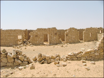
| Village Temains | The village was completely destroyed with the exception of few deserted and partially destroyed houses. |
| Ethnically Cleansing | al-Khalasa inhabitants were completely ethnically cleansed. |
| Town's Name Through History | Nabateans referred to al-Khalasa by Elusa. |
| Schools | al-Khalasa had an elementary school for boys which was founded in 1941. |
| Archeological Sites | al-Khalasa contains a ruined town, inscribed architectural fragments, tombs, Nabatean theater and the remains of the largest church in the Negev. |
| Exculsive Jewish Colonies That Usurped Village Lands |
Village lands are being used by the Israelis Army as a military training grounds. |
| Featured Video | |
Village Before NakbaThe village stood in the midst of bare mounds and overlooked wide expanses of land on all sides except the south. It was on the confluence of the wadis of al-Awsaja and al-Khalasa. It was identified with the Nabatean town of Elusa by E. Robinson in 1838. The site appears to have been a station on the caravan route from Petra to Gaza. According to a biography of Hilarion written by St. Jerome in the early fifth century, when Hilarion visited Elusa in the fourth century he was served wine from local vineyards. The town of Elusa is found on the sixth century Madeba mosaic map of Palestine. It appears to have been a capital city in the administrative region of Palestina Tertia until the Islamic conquest.We know very little about al-Khalasa in the early Muslim period. The Arab geographer Muhammad al-Dimashqi (d. 1327) mentioned it as a town lying within the administrative jurisdiction of Gaza , and al-Maqrizi (d. 1441) said that it was one of the larger 'cities' in the southern part of Palestine. As traffic on the Negev trade routes declined however al-Khalasa diminished in importance. It was not until the early years of the present century that it attracted much attention; in 1905 the École Biblique of Jerusalem studied the archeological remains there, and the British Survey drew up a plan of the entire archaeological site in 1914. This renewed interest in al-Khalasa coincided with a decision by Muslim Bedouin from the al-Azazima tribe to settle there. They built a village that was triangular in outline, sandwiched between the two wadis' banks. Their houses were made of stone and mud. Al-Khalasa had an elementary school, established in 1941, and also had a number of shops. The villagers drew their drinking water from a well and earned their living through animal husbandry and commerce. Excavations in al-Khalasa in 1938 revealed a ruined town, inscribed architectural fragments, and tombs. Between 1973 and 1980, three seasons of excavation at al-Khalasa uncovered the remains of an enlarged Nabatean theater, the largest church in the Negev, other ecclesiastical buildings, defense towers built into the city wall, and houses. Village Occupation and Ethnic CleaningThe village probably came under Israeli control fairly early in the war. The commander of the Negev Brigade, Nachum Sarig, is quoted in the History of the Haganah as saying after the war that, 'By May 15, the entire Negev was under complete Hebrew control.' But there is a possibility that, like Beersheba, it held out as late as October 1948, until Operation Yoav.Zionists Colonies on Village LandsThere are no Israeli settlements on village lands. The area is used for military training.Village TodaySome of the village houses are still standing but are deserted and partially destroyed. To the west of the village site is a well that is still functional, with a round mouth and metal ladder. A large house with a rectangular outline and eight rooms stands several meters away, to the west of the well. Behind it one can see the rubble of ten destroyed houses. Remnants of the cemetery are also visible in the northern part of the site. Next to the cemetery there is an archaeological dig and some bulldozed village houses. About fifteen houses, half destroyed, are located on the southern and western side of the site.SourceDr. Walid al-Khalidi, 1992: All That Remains. |
|
| Related Maps | Town Lands' Demarcation Maps خرائط للقضاء توضح حدود القرى والاودية Town's map on MapQuest View from satellite Help us map this town at WikiMapia |
| Related Links | Wikipedia's Page Google Search Google For Images Google For Videos |
| More Information | في كتاب كي لا ننسى المزيد من موقع هوية |
- Village well, currently it's in use by Israeli framers, 1990

Scanned from "All That Remains" by Dr. Walid Khalidi 3 - Remains of a village houses, 1990

Scanned from "All That Remains" by Dr. Walid Khalidi 2 - Remains of a village house, 1990

Scanned from "All That Remains" by Dr. Walid Khalidi 2 - Southern Palestine. Well at Khalasa 1900 to 1926

Posted by Joehar Hamdan - مدرسة الخلصه
Posted by محمد ألأعسم - Remains of a house, north of the main site.

Posted by Uri Zackhem - A bird on a ruin

Posted by Uri Zackhem - More of the house to the north

Posted by Uri Zackhem 1 - More of the house to the north.

Posted by Uri Zackhem 1 - More of the house to the north.

Posted by Uri Zackhem - This is probably the mill.

Posted by Uri Zackhem - This is probably the mill.

Posted by Uri Zackhem 1 - This is probably the mill.

Posted by Uri Zackhem - Village remains

Posted by Uri Zackhem - Vilage remains

Posted by Uri Zackhem - Village remains

Posted by Uri Zackhem - Graveyard, SE of the village

Posted by Uri Zackhem - Some remains across Wadi Shalala.

Posted by Uri Zackhem - The school? A garrison? A house with a courtyard, SW of the village, adjacent to a well

Posted by Uri Zackhem - A water reservoir near the well

Posted by Uri Zackhem 1 - The well

Posted by Uri Zackhem 2 - The motor was placed on this concrete slab

Posted by Uri Zackhem - Remains of the Nabatean western church.

Posted by Uri Zackhem - بيوت القريه
Posted by abu raya - بيوت القريه

Posted by abu raya - الخلصه

Posted by abu raya - اثار ردم بيوت القريه

Posted by abu raya - الباقي من بيوت القريه

Posted by abu raya - بيوت القريه

Posted by abu raya - ابار القريه

Posted by abu raya - بيوت الخلصه

Posted by abu raya - منظر عام لموقع القريه

Posted by abu raya - اثار بيوت القريه

Posted by abu raya - اراضي القريه

Posted by abu raya - بيوت القريه

Posted by abu raya - صوره قديمه من الخلاصه سنه 1917

Posted by abu raya - جولة بين انقاض القرية المدمرة قامت بها مجموعة زوخروت

- جولة بين انقاض القرية المدمرة قامت بها مجموعة زوخروت #2

- أبار الخلصة الشهيرة قبل النكبة - The well at al-Khalasa

Want to browse more? 80,000 pictures were grouped in these gallaries:
| Display Name | Clan/Hamolah | Country of Residence |
- Tracing All That Remains of al-Khalasa since Nakba Duration: 8 min 43 sec
No links have been shared yet, be free to the first to share the first link.
 Fake Valor: Why Did Zionist Jews Hoist Nazis Flag on Their Ships in the 1930s?
What is new?
-
Facts About Oct. 7th Gaza Raid

-
Remined Us Please: Who Did Rape Whom? Was it Palestinians who raped Israelis? Or, was the other way around? You'll be the judge
-
When Prof. Edward Said was invited to debate Bibi Netanyahu in the 1980s, watch what happened!
-
Ezra Klein of the NY Times on the "Jewish Race".
-
Abusing Blood Libel!
-
How and why Israeli Jewry has become the most hated cult?
-
Did Israeli Soldiers Activate The Hannibal Direective On Oct. 7th? You Be The Judge
-
Zionist FAQ: Isn't it true that Palestinians don't want peace? Palestinians never accepted the two-state solution
- Facts about Haavara (Transfer) Agreement between Ben-Gurion & Hitler
-
Haavara FAQs: Why Did Zionist Jews Hoist Nazis' Flags on Their Ships in the 1930s?
- Haavara FAQs: When Chaim Weizmann met FDR in mid-1943, why was he silent about rescuing European Jewry?
-
Dear ChatGPT: How did Palestinians resist Napoleon's invasion of their country in 1799?
-
Dear ChatGPT: Gaza had a vibrant Jewish community in the mid-17th century. What happened to them?
-
Dear ChatGPT: Why did the Jewish Agency suppress news of the Holocaust during WWII?
-
Video Playlist: Jews share their DNA tests to end the conflict for good.
-
A Tale of Two Conflicts: Examining the Definition of Genocide
-
Prof. Abraham Polak And The Suppressed History of the Khazars and European Jewry
-
How Ronald Reagan would have framed the genocide in Gaza if he were still alive?
-
Haavara FAQs: Let us do the math: how many German Jews did The Haavara Agreement save?
-
Zionist FAQs: The Hebron Massacre of 1929, "clearly proves" that Palestinians are antisemitic, how could you deny it?
-
Zionist FAQs: Why Anti-Zionist Is Not Antisemitism?
-
Zionist FAQs: Isn't it true that the KGB created Palestinian Nationalism in the early 1960s?
- Zionist FAQs: Muslims are killing Muslims all the time; why are Israeli Jews being singled out in the media?
- Zionist FAQs: How is Israel an apartheid state when 20% of its citizens are Arabs who enjoy full rights?
-
Haavara FAQs: Why Did Dorothy Thompson Flip From A Zionist Advocate to A Silenced Dissenter?
-
Haavara FAQs: Analysis of Herzl's Uganda Scheme and how it could have saved millions of Jews.
-
Haavara FAQs: Why did Hayim Greenberg describe American Jewry as "morally bankrupt" in early 1943?
-
Haavara FAQs: What if the Evian Conference was a resounding success? What would have been the impact of saving European Jewry on Zionism?
- Haavara FAQs: What if the six million were saved, how that would have impacted the Zionist project?
-
Haavara FAQs: How did Zionist leaders react when Europe's Jews lingered in the DP camps after WWII ended?
-
Why does the American Jewish community repeat lies that David Ben-Gurion had debunked before he died?
-
Who has the power to rename the Tatar/Khazar Gene Marker to Jewish IV?
-
Zionist FAQs: Why won't Egypt, Syria, and Jordan take their people back? Jews are indigenous to Palestine, and Arabs immigrated after Jews developed the country. Arabs should leave.
-
Haavara FAQs: Did Hitler and the Nazis conflate between Judaism and Zionist? If that wasn't case, then why?
-
Haavara FAQs: Winston Churchill and antisemitism, a collection of articles written Churchill.
-
Haavara FAQs: Broken by country, how many Jews survived vs. killed during the Holocaust?
-
Haavara FAQs: Why did European Jews vote with their feet and to immigrated to the Americas, not Palestine, after WWII?
-
Watch this American Jewish Girl describing Israeli Jews' cognitive dissonance like no other in under two minutes
-
Haavara FAQs: When the Nazis went out of their way to hide the Holocaust, Israeli Jews did the exact opposite by broadcasting their genocide of Gazans. But why?
-
Haavara FAQs: How Zionist Jews went out of their to show their appreciation to Nazism and Fascism?
- Haavara FAQs: Why Zionist leaders were against bombing the death camps & the Railroads leading to them?
-
Haavara FAQs: Hitler's message to the British and American people: If Jews are such noble citizens and you care about them, how come you're not letting them in? I will gladly ship them to you at my expense, even on luxury liners!
-
A shortlist of Zionist and Israeli false flag operations in the name Jews.
-
The Most Moral Army
- The Land of Kapos (Israel): Where the brave are boycotted and Kapos walk free.
- Why did early Zionists often named their communal enterprises "colonial"?
- Zionist Relations with Nazi Germany by Faris Glubb
-
Two NY Times advertisements by Zionists in the early 1943 that exposes Zionists' treason at the height of the calamity
- Facts Not Lies about the Palestinian-Israeli Conflict.
- Site's pictures have been categorized
- Campgain Against Lice
- A Survey of Palestine, the official source about Palestine before Nakba produced by the British Mandate; over 1200 pages.
- Satellite View & Google Earth: Over 6,000 placemarks identifying all destroyed towns, W. Bank & Gaza Strip Towns, & refugee camps.
- PalestineRemembered.com and its Nakba Oral History Project were featured on al-Jazeera Satellite TV.
- Nakba Oral History Video Podcast:
 Over 700 Oral History interviews (including 3,500+ hours of recording) can be viewed online.
 - Palestine Village Statistics Project
- Gaza Jail Break
- النسخة العربية للموقع الان متوفرة
- Videos: Documenting the destroyed villages in video: Tracing all that remains since Nakba.
- Videos: Responding to Zionist Propaganda
- Interview: The ethnic cleansing of Palestine: George Galloway interviews Israeli Historian Ilan Pappe.
- For Palestinians, memory matters. It provides a blueprint for their future By George Bisharat.
- Zionist FAQ now available in Hebrew שאלות שציונים שואלים, עכשיו בעברית
- Video: The Stephen Walt and John Mearsheimer report on the influence of the Israel Lobby on U.S. Foreign Policy
- The Palestinian-Israeli conflict for beginners
