| PalestineRemembered | About Us | Oral History | العربية | |
| Pictures | Zionist FAQs | Haavara | Maps | |
| Search |
| Camps |
| Districts |
| Acre |
| Baysan |
| Beersheba |
| Bethlehem |
| Gaza |
| Haifa |
| Hebron |
| Jaffa |
| Jericho |
| Jerusalem |
| Jinin |
| Nablus |
| Nazareth |
| Ramallah |
| al-Ramla |
| Safad |
| Tiberias |
| Tulkarm |
| Donate |
| Contact |
| Profile |
| Videos |
Welcome To Bir Zeit - بيرزيت (ביר זית)
|
District of Ramallah
Occupied days ago |
العربية Google Earth |
 |
Gallery (249) |
- Statistics & Facts
-
Before & After

- Satellite View
- Articles 4
- Pictures 249
- Members 13
- Families
- Wikipedia
- ARIJ Guide
- Videos 4
- Guest Book 10
- Links 8
| Statistic & Fact | Value | ||||||||||||||||||||||
| Distance From District | 11 km north of Ramallah | ||||||||||||||||||||||
| Elevation | 765 meters | ||||||||||||||||||||||
| Before & After Nakba, Click Map For Details |
|||||||||||||||||||||||

|
|||||||||||||||||||||||
| Land Ownership |
**Town Lands' Demarcation Maps |
||||||||||||||||||||||
| Land Usage As of 1945 |
|
||||||||||||||||||||||
| Population |
|
||||||||||||||||||||||
| Near By Towns |
|||||||||||||||||||||||
|
|
|||||||||||||||||||||||
| Featured Video | |||||||||||||||||||||||
| ARIJ Guide | |||||||||||||||||||||||
3.

4. 
5. 
6. 
7. 
8. 
9. 
10. 
11. 
12. 
13. 
14. 
15. 
16. 
17. 
18. 
Click here to browse online. |
|||||||||||||||||||||||
| Related Maps | Town Lands' Demarcation Maps خرائط للقضاء توضح حدود القرى والاودية View from satellite Town's map on MapQuest Help us map this town at WikiMapia |
||||||||||||||||||||||
| Related Links | Wikipedia's Page Facebook Page ARIJ Guide Google Search Google For Images Google For Videos في كتاب بلادنا فلسطين دليل أريج المزيد من موقع هوية |
||||||||||||||||||||||
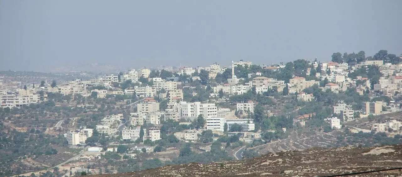
- General view of the town. Picture taken from the Khirba area that over looks the town, and it is looking northeast

5 - The Municipality Building

- المجلس المحلي الأول في بيرزيت 1924-1937 منصور أبو داهود-يعقوب يوسف جاسر-بطرس العرنكي(الرئيس)- حنا موسى علوش- موسى ربيع

- Panoramic view looking west, taken from the eastern edges of the town

2 - Panoramic view looking of the hills behind the town, do you know the direction and location? please provide in the comments area

1 - The main mosque

- The main mosque #2

1 - Sunset over the town taken from western edges of the town

1 - Birzeit University, the main campus

3 - Birzeit University main campus

2 - Roman Khriba/ruins located on the western edges of the town

1 - Roman Khribart/ruins located on the western edges of the town, possible oil or wire presses #2

2 - Roman ruins / Khriba located on the western edges of the town. (#3) - 12

1 - A General view

- Birzeit University main campus

1 - Birzeit University main campus

2 - Rocky hills around the town

1 - A new street in the town, if you know location, please provide in the comments section?

4 - Another general view from the eastern edges

2 - General view

2 - General view from the western edges of the town towards Abu Sheidim

1 - Roman Catholic Church

Posted by Samer82 2 - The Greek Orthodox Church, Established 1715 - Rehabilitated 1871

Posted by Samer82 3 - Birzeit - The Arab Angelical Church, Established 1903

Posted by Samer82 1 - جامعة بير زيت تصوير ناصر شحاده عوريف

Posted by naser abed - مسجد من مساجد بير زيت تصوير ناصر شحاده عوريف

Posted by naser abed 1 - old city of birzeit

Posted by samer mustafa 1 - old city of birzeit

Posted by samer mustafa 1 - birzeit municipality

Posted by samer mustafa - old city of birzeit

Posted by samer mustafa 2 - old city of birzeit

Posted by samer mustafa - old city of birzeit

Posted by samer mustafa - old city of birzeit

Posted by samer mustafa 1 - old city of birzeit

Posted by samer mustafa - old city of birzeit

Posted by samer mustafa 2 - old city of birzeit

Posted by samer mustafa - old city of birzeit

Posted by samer mustafa - old city of birzeit

Posted by samer mustafa 1 - بيت الست انيسة في شارع عطارة، سكنه الشهيدين عبد القادر الحسيني وكمال ناصر، عشت فيه 7 سنوات جميلة

Posted by جبريل محمد - مسجد بير زيت ،يوم الإثنين 15/8/1983 5 ذو القعدة 1403ه Birzeit Mosque on Monday 8-15-1983

Posted by Abu Najm Bassel - رقصة لطالبات روضة في بيرزيت عام 1971

Posted by محمود - طلاب مدرسة الأمير حين الثانوية عام 1973

Posted by محمود 1 - منظر لبلدة بيرزيت

Posted by محمود - Birzeit University (From Australians for Palestine)

Posted by Rami Atwan - Birzeit

Posted by Ibrahim Sami Ali - ملابس اهل المدن في الخمسينيات 1

Posted by ابوعبد الرحمن العطاري - تخريج فوج من طلبة كلية بير زيت في الخمسينيات

Posted by ابوعبد الرحمن العطاري - بير زيت -كلية الادب

Posted by رولا سرحان - بير زيت -كلية الحقوق

Posted by رولا سرحان - شارع عام شرقي مسبح عين الحمام

Posted by اسامه - منظر قريب من المسبح

Posted by اسامه - جبال بيرزيت شرق المسبح

Posted by اسامه - شارع عام شرق بيرزيت - المسبح

Posted by اسامه - متحف الشعب - بيرزيت

Posted by اسامه - جامعة بير زيت

Posted by yazan bargouthi - الخوري بولص شاهين وأقاربه: يعقوب الخوري ابراهيم وعبداللة حنا شاهين وجراسموس الخوري ابراهيم ومتري صالح داهود والمعلم شحادة الخوري ابراهيم.-1939

- صورة من الماضي عام 1938: اسحق عبدالله القسيس وأولاده : لافي على يساره ونايف على يمينه ويعقوب وداهود وجريس .... .

- مبنى بلدية بير زيت - بعدسة: سهيل مخول

Posted by سهيل مخول - البيوت القديمة في بيرزيت - بعدسة : سهيل مخول

Posted by سهيل مخول - البيوت القديمة في بيرزيت - بعدسة : سهيل مخو

Posted by سهيل مخول - البيوت القديمة في بيرزيت وكنيسة الاتين - بعدسة : سهيل مخو

Posted by سهيل مخول - البيوت القديمة في بيرزيت - بعدسة : سهيل مخول

Posted by سهيل مخول - البيوت القديمة في بيرزيت - بعدسة : سهيل مخول

Posted by سهيل مخول - البيوت القديمة في بيرزيت - بعدسة : سهيل مخول

Posted by سهيل مخول - البيوت القديمة في بيرزيت - بعدسة : سهيل مخول

Posted by سهيل مخول - البيوت القديمة في بيرزيت وكنيسة الروم - بعدسة : سهيل مخول

Posted by سهيل مخول - البيوت القديمة في بيرزيت وكنيسة الروم - بعدسة : سهيل مخول

Posted by سهيل مخول - البيوت القديمة في بيرزيت وداخل كنيسة الروم - بعدسة : سهيل مخول

Posted by سهيل مخول - البيوت القديمة في بيرزيت - بعدسة : سهيل مخول

Posted by سهيل مخول - البيوت القديمة في بيرزيت - بعدسة : سهيل مخول

Posted by سهيل مخول - جامعة بير زيت - بعدسة سهيل مخول

Posted by سهيل مخول - جامعة بير زيت - بعدسة :سهيل مخول

Posted by سهيل مخول - جامعة بير زيت - بعدسة :سهيل مخول

Posted by سهيل مخول - جامعة بير زيت - بعدسة :سهيل مخول

Posted by سهيل مخول - جامعة بير زيت - بعدسة :سهيل مخول

Posted by سهيل مخول - جامعة بير زيت - بعدسة :سهيل مخول

Posted by سهيل مخول - كنيسة ومدرسة الاتين في بير زيت - بعدسة: سهيل مخول

Posted by سهيل مخول - كنيسة ومدرسة الاتين في بير زيت - بعدسة: سهيل مخول

Posted by سهيل مخول - كنيسة ومدرسة الاتين في بير زيت - بعدسة: سهيل مخول

Posted by سهيل مخول - مجموعة من الجليل في زيارة لبير زيت - بعدسة سهيل مخول

Posted by سهيل مخول - Bir Zeit, March 1918

Posted by palestinehistory - منظر عام

- Entrance to the university

1 - أمل ناصر من اليمين، ومن اليسار نجلا ناصر، التقطت في بلدة بيرزيت عام 1949.

- حي المرج في بيرزيت (يظهر في الصورة مسجد عمر بن الخطاب)، سنة 2023

Posted by مجدل عيسى - جامعة بيرزيت، شارع كلية الآداب شتاء 2022

Posted by مجدل عيسى - طالبات مدرسة بيرزيت داخل حافلة خلال رحلة ترفيهية، 1947-1948---من ألبوم ريما ترزي.

- صورة غير ملونة تظهر فيها امرأة بالثوب الفلسطيني في بلدة بيرزيت، وُجدت الصورة ضمن مجموعة موسى علوش.

- زوجان في استديو من بلدة بيرزيت عام ١٩٣٦

- صورة لمقر جمعية سيدات بيرزيت القديم عام 1985

- عائلة من بلدة بيرزيت _ رام الله.. عام 1965

- رحلة صيد في جبال بيرزيت. رام الله، 1962.

- بيت جد الفنان الفلسطيني سليمان منصور في بيرزيت -- Yousef Odeh

- جولة بين بيوت بيرزيت القديمة

- جولة بين بيوت بيرزيت القديمة
#2

- جولة بين بيوت بيرزيت القديمة
#3

- صور من بير زيت وبلدتها القديمة -- تصوير بهاء جيتاوي

- صور من بير زيت وبلدتها القديمة -- تصوير بهاء جيتاوي
#2

- صور من بير زيت وبلدتها القديمة -- تصوير بهاء جيتاوي
#3

- صور من بير زيت وبلدتها القديمة -- تصوير بهاء جيتاوي
#4

- صور من بير زيت وبلدتها القديمة -- تصوير بهاء جيتاوي
#5

- صور من بير زيت وبلدتها القديمة -- تصوير بهاء جيتاوي
#6

- صور من بير زيت وبلدتها القديمة -- تصوير بهاء جيتاوي
#7

- حفل تثبيت عدد من أولاد بلدة بيرزيت في دير اللاتين، بحضور البطريك اللاتين والأب أنطون بوزو وعدد من رجالات بيرزيت عام 1962

- "أسماء عرنكي" 1948م - بيرزيت/ رام الله

- عائلة الكيلة - بيرزيت 1908

- بيرزيت في عام 1896م "مدرسة اللاتين"

- أسبوع التراث - بيرزيت -- واجد النوباني -- 2022

- أسبوع التراث - بيرزيت -- واجد النوباني -- 2022 #2

- أسبوع التراث - بيرزيت -- واجد النوباني -- 2022 #3

- أسبوع التراث - بيرزيت -- واجد النوباني -- 2022 #4

- أسبوع التراث - بيرزيت -- واجد النوباني -- 2022 #5

- أسبوع التراث - بيرزيت -- واجد النوباني -- 2022 #6

- أسبوع التراث - بيرزيت -- واجد النوباني -- 2022 #7

- أسبوع التراث - بيرزيت -- واجد النوباني -- 2022 #8

- أسبوع التراث - بيرزيت -- واجد النوباني -- 2022 #9

- أسبوع التراث - بيرزيت -- واجد النوباني -- 2022 #10

- أسبوع التراث - بيرزيت -- واجد النوباني -- 2022 #11

- أسبوع التراث - بيرزيت -- واجد النوباني -- 2022 #12

- صورة غير ملونة لإمرأة ترتدي الثوب الفلسطيني المطرز (حسنة) من بلدة بيرزيت فترة السبعينيات

- ناصر سليمان شاهين وزوجته مارغريت بربار
وعبدالله بربار وزوجته امل سليمان ناصر شاهين التقطت الصورة عام 1947

- يظهر في اللقطة عائلة عبد الجليل ابو عواد (من اليمين الصف الاول نعمة، فاطمة، نعيم، رويده، وليد ،عوده، تهاني، وعبد الجليل ابو عواد)
حيث تعتبر حامولة آل أبو عواد من أعرق العائلات في بلدة بيرزيت وجزء لا يتجزأ من سكانها الأصليين المتمثلة بحمولة أم عيد وشاهين وعبدالله ومسلم ووشحة
وجدت الصورة ضمن مجموعة وليد عواد

- صورة لمقر جمعية سيدات بيرزيت القديم عام 1985

- لقطة لعائلة الكيلة، من اليمين وقوفاً أيوب سليمان، صقر عيسى وأندراوس عيسى كيله، ومن يمين اللقطة جلوساً سلامة يعقوب، سليمان حنا، أم سليمان العطاري، نقولا حنا، يوسف ابراهيم الكيله
وجدت ضمن مجموعة موسى علوش

- جامع بيرزيت الكبير قديما والذي تم بناؤه عام 1955
وجدت ضمن مجموعة موسى علوش

- صورة بالقرب من مكتب البريد الفلسطيني بيرزيت ويظهر في الصورة شاحنة للجيش

- الخوري نقولا حلوة يتوسط عائلة يعقوب عيسى حلوة وزوجته غالية جاسر، وأبناؤهم نائل وناجد، وبناتهم هيام (يمين)، وسهاد (من الأمام) ونجوى (من اليسار) عام 1963

-
صورة لدير اللاتين بيرزيت قديم

- صوره من العام 1979 للدكتور منير ناصر وعائلته

- حفل تثبيت عدد من أولاد بلدة بيرزيت في دير اللاتين، بحضور بطريرك اللاتين والأب أنطون بوزو وعدد من رجالات بيرزيت عام
1962

- على اليمين ام ابراهيم معزوزه اخت نعوم بربار واخمه ابراهيم بربار ابو راضي
وعلى الشمال ام توفيق الكيله

- فريدة إبراهيم فرح، ولدت عام 1906 وتوفيت عام 1973

- حبيب حنانيا عبد الله وزوجته عام 1978 أصالة الزي التراثي الفلسطيني القمباز والحطة مع الثوب المطرز

- شحادة خوري إبراهيم، مؤلف كتاب "تاريخ الكنيسة الاورثودكسية" الذي أصدره بالإشتراك مع الخوري نقولا قسيس عام 1925، وهو من وضع مخطوطة تاريخ عشيرة العرانكة عام 1932

- شحادة خوري إبراهيم، مؤلف كتاب "تاريخ الكنيسة الاورثودكسية" الذي أصدره بالإشتراك مع الخوري نقولا قسيس عام 1925، وهو من وضع مخطوطة تاريخ عشيرة العرانكة عام 1932

- الخوري بولص شاهين يعمد الطفل مهند مجج ويبدوا في الصورة شبلي خليل الخوري كيلة وبسيمة شبلي كيلة عام 1960

- الثوب الفلسطيني

- صورة غير ملونة لمشهد عام طبيعي من بلدة بيرزيت
وجدت الصورة ضمن مجموعة اميل عشراوي

- صورة لأسما عرنكي، خالة عبلة عرنكي، مرتديةً الثوب الفلسطيني وتحمل أحد أطفال العائلة وذلك في محيط بيتهم في بيرزيت، والتقطت في الفترة ما بين 1948-1949

- مجموعة من أهالي بيرزيت يهنئون أهالي عطارة في حفل زفاف عباس المغربي

- الحاج عبد اللطيف أبو عواد، ولد عام 1901 وتوفي عام 1995، وزوجته سارة عواد عبد المجيد

- سليمان موسى نصار سعد، كان محكوماً عليه بالاعدام زمن الإحتلال التركي العثماني عام 1918 لكنه نجا منه

- صورة غير ملونة لمجموعة من الأطفال في بلدة بيرزيت بتاريخ 9 نيسان 1961

- مجموعة صور فترة بناء وتدشين المبنى الجديد لمدرسة دير اللاتين بيرزيت وتدشينه من قبل بطريرك الطائفة اللاتينية ألبرتو غوري وذلك عام 1953

- مجموعة صور فترة بناء وتدشين المبنى الجديد لمدرسة دير اللاتين بيرزيت وتدشينه من قبل بطريرك الطائفة اللاتينية ألبرتو غوري وذلك عام 1953 #2

- مجموعة صور فترة بناء وتدشين المبنى الجديد لمدرسة دير اللاتين بيرزيت وتدشينه من قبل بطريرك الطائفة اللاتينية ألبرتو غوري وذلك عام 1953 #3

- مجموعة صور فترة بناء وتدشين المبنى الجديد لمدرسة دير اللاتين بيرزيت وتدشينه من قبل بطريرك الطائفة اللاتينية ألبرتو غوري وذلك عام 1953 #4

- من يمين اللقطة خليل سليمان الحجة وزوجته عفيفة وابنهم فؤاد الحجة والطفلة منيرة

- جموعة صور لعدد من العسكريين الإنجليز الفارين من الخدمة ويظهر في الصورتين المرحوم سليم خليل الصايج بالزي العسكري للجهاد المقدس

- جموعة صور لعدد من العسكريين الإنجليز الفارين من الخدمة ويظهر في الصورتين المرحوم سليم خليل الصايج بالزي العسكري للجهاد المقدس #2

- صورة غير ملونة تظهر فيها سيدة برفقة أطفالها في بلدة بيرزيت -- see the comment section for the details

1 - ظهر من يمين اللقطة خليل متة، خليل صايج، عدنان قسيس، خليل كيلة، وعميد عودة في مركز نادي شباب بيرزيت عام 1971

- صورة عائلية، وجدت ضمن مجموعة عبلة عرنكي الأرشيفية، وفيها من اليمين أسامة عرنكي، وإلى اليسار تقف عبلة عرنكي، بينما يتوسطهم الضابط العسركي سليمان ناصر الذي كان في زيارة إلى بيرزيت؛ حيث كان يخدم في الجيش الأردني، والتقطت الصورة عام 1963

- من اليسار: راضي ابراهيم بربار(مكوجي)، عرنكي عرنكي أبو المحاميه سناء وأبو الدكتوره عبير، الضابط في الجيش الأردني سليمان موسى عرنكي، أخو إيمي عرنكي. يمكن لابس القمباز أحد ابناء أبو سميح بربار. الدار ذات القرميد هي دار توفيق ناصر، مطعم النورج حالياً.
-- 1941

- صورة لإيمي عرنكي، والدة عبلة عرنكي، مرتديةً الثوب الفلسطيني في بيرزيت، وتعود لعام 1940.

- جميلة خليل سلامة الكيلة زوجة شبلي خليل الخوري كيلة، ولدت عام 1899 وتوفيت عام 1982

- صورة التقطت في 20 تشرين الأول 1920، تجمع كلا من بطرس عيسى العبد، وزوجته شفا خليل الخوري، حيث يظهر العبد واقفاً مرتديا طربوشاً وقمبازا وحزاماً تقليديين، فيما تقف الخوري بجانبه مرتدية ثوباً فلسطينياً تقليدياً وغطاء رأس مطرزين.

- فرح ابراهيم فرح وزوجته معزوزة يعقوب بربار
وجدت ضمن مجموعة موسى علوش

- عودة عبد الهادي أبو عواد يقف الى جانب سيارة شيفروليه مصنوعة عام 1941

- جامعة بيرزيت عام 1981

- جامعة بيرزيت عام 1981 #2

- لِّيِّةْ ابراهيم سالم مْسَلَّم في حوش الدُوَّارَه.

- منطقة نادي بيرزيت في بيرزيت عام 2005 .

- معلمات وطالبات مدرسة اللاتين في بيرزيت عام 1954

- أهالي بلدة بيرزيت يحضرون العروس نهاد اسطفان سلامة من جفنا الى بلدة بيرزيت للقاء عريسها سليمان يوسف بربار

- اسحق عبد الله القسيس مع أولاده، من يمين جلوساً نايف، اسحق، لافي، من اليمين الى اليسار وقوفاً يعقوب، داهود، وجريس

- رشيد محمد عمر أبو عواد وزوجته مريم عام 1963

- ابراهيم قطاطو ابو عيسى وناديا كيلة عام 1949

- طالبات مدرسة بيرزيت داخل حافلة خلال رحلة ترفيهية، 1947-1948. من ألبوم ريما ترزي.

- بناء عائلة شاهين يجتمعون بمناسبة عرس أنيس منصور وكمال والخوري بولص شاهين عام 1939

- صورة من زفة عرس في بلدة بيرزيت..ويظهر شكري ناصر ابو غالب وخلفه موسى ابو ديه

- طلاب مدرسة اللاتين في بيرزيت، الصف الأعلى من اليمين: الخوري نعمة الله سعادة، هودة شحادة، جريس السايح، موسى صالح ربيع، لويس خليل سعادة، قسطندي يوسف علوش، ابراهيم خليل سعادة، الخوري بشاره عبد ربه. الصف الثاني من اليمين: موسى سليمان ربيع، اسكندر جريس عبيد، سعادة عبد الله، لويس عبد الله السايح، لويس عودة شحادة، حنا عطاالله سمندر، حنا موسى علوش. الصف الثالث من اليمين: جريس صالح سعادة، جريس عودة شحادة، جريس ابراهيم سمندر، ابراهيم صليبا سعادة، حنا صالح سعادة، ابراهيم صالح ربيع، حنا سليمان بربار. الصف الرابع من اليمين: حنا يوسف ربيع، يوسف صليبا سعادة، خليل عيسى سعادة، يوسف سليمان بربار، جريس عطاالله سمندر، خليل يعقوب صايج، وخليل سليمان ربيع.
1896

- حفل زفاف نعيم عصفور في بلدة القديمة في بيرزيت عام 1959

- الخوري بولص شاهين يكلل العروسين عيسى خوري وروز سمندر

- طلاب مدرسة دير اللاتين بيرزيت عام ١٩٦٢
اسماء الاشخاص بالصوره موسى علوش، الياس عبيد ، فيكتور سعادة، ابراهيم الناطور، حنا عيسى، عدنان فرحات ، والخوري على اليسار زائر من ايطاليا
مجموعة موسى علوش

- التقطت هذه الصورة عام 1959 خلال حفل زفاف سليم خليل الصايج في البلدة القديمة في بيرزيت

- مجموعة من الصور لأهالي البلدة تعود للعام 1956 في زفاف عرنكي سليمان عرنكي على جميلة حنا علوش في بلدة بيرزيت

- مجموعة من الصور لأهالي البلدة تعود للعام 1956 في زفاف عرنكي سليمان عرنكي على جميلة حنا علوش في بلدة بيرزيت #2

- مجموعة من الصور لأهالي البلدة تعود للعام 1956 في زفاف عرنكي سليمان عرنكي على جميلة حنا علوش في بلدة بيرزيت #3

- مجموعة من الصور لأهالي البلدة تعود للعام 1956 في زفاف عرنكي سليمان عرنكي على جميلة حنا علوش في بلدة بيرزيت #4

- مجموعة من الصور لأهالي البلدة تعود للعام 1956 في زفاف عرنكي سليمان عرنكي على جميلة حنا علوش في بلدة بيرزيت #5

- مجموعة من الصور لأهالي البلدة تعود للعام 1956 في زفاف عرنكي سليمان عرنكي على جميلة حنا علوش في بلدة بيرزيت #6

- مجموعة من الصور لأهالي البلدة تعود للعام 1956 في زفاف عرنكي سليمان عرنكي على جميلة حنا علوش في بلدة بيرزيت #7

- كلية الهندسة

- صورة قديمة للجامعة

- حوش العتم

- منظر عام للبلدة القديمة

- مشهد في البلدة القديمة

- جولة في التلال المحيطة-- Yousef Odeh

- جولة في التلال المحيطة-- Yousef Odeh #2

- جولة في التلال المحيطة-- Yousef Odeh #3

- جولة في التلال المحيطة-- Yousef Odeh #4

- جولة في التلال المحيطة-- Yousef Odeh #5

- جامعة بيرزيت

- جولة بين بيوت وأزقة البلدة القديمة -- Abo Gheith

- جولة بين بيوت وأزقة البلدة القديمة -- Abo Gheith #2

- جولة بين بيوت وأزقة البلدة القديمة -- Abo Gheith #3

- جولة بين بيوت وأزقة البلدة القديمة -- Abo Gheith #4

- جولة بين بيوت وأزقة البلدة القديمة -- Abo Gheith #5

- صورة تذكارية داخل أستوديو لعائلة يوسف إبراهيم مسلم وزوجته مارتا من بير زيت قضاء رام الله عام 1921..

- بيت جد الفنان سليمان منصور -- Yousif Odeh

- بيت جد الفنان سليمان منصور -- Yousif Odeh #2

- بيت جد الفنان سليمان منصور -- Yousif Odeh #3

- بيت جد الفنان سليمان منصور -- Yousif Odeh #4

- بيت جد الفنان سليمان منصور -- Yousif Odeh #5

- البلدة القديمة -- يوسف عودة

- منظر عام -- يوسف عودة

- منظر عام
- منظر عام #2

- بيت جد الفنان الفلسطيني سليمان منصور -- يوسف عودة

- بيت قديم -- يوسف عودة

- بيت قديم -- يوسف عودة

- منظر عام -- يوسف عودة

- احد بيوت القرية القديمة -- Yousif Odeh

- بيت قديم -- يوسف عودة

- شجرة زيتون معمرة -- يوسف عودة

- بيت قديم -- يوسف عودة

- منظر عام -- يوسف عودة

- البلدة القديمة -- يوسف عودة

- بيت قديم -- يوسف عودة

- بيت قديم في البلدة القديمة -- يوسف عودة

- بيت قديم -- يوسف عودة

- البلدة القديمة -- Yousif Odeh

- البلدة القديمة -- Yousif Odeh #2

- البلدة القديمة -- Yousif Odeh #3

- البلدة القديمة -- Yousif Odeh #4

- صورة جوية للحرم الجامعي بين أحضان الطبيعة، حيث يلتقي الحلم بالمعرفة، ويُرسم المستقبل من بين القاعات، والمختبرات، والمساحات الخضراء

- كلية الهندسة -- يوسف عودة

- في التلال المحيطة -- يوسف عودة

- صور للجامعة تعود لثمانينيات القرن الماضي -- مؤسسة رواق

- صور للجامعة تعود لثمانينيات القرن الماضي -- مؤسسة رواق #2

- صور للجامعة تعود لثمانينيات القرن الماضي -- مؤسسة رواق #3

- صور في البلدة القديمة تعود لثمانينيات القرن الماضي -- مؤسسة رواق

- طريق السوسنة -- Ibstisman Sulieman

- اطلالة من جبال بيرزيت على ساحلنا الفلسطيني

- اطلالة من جبال بيرزيت على ساحلنا الفلسطيني #2

- موسى حنا ناصر..مكان الولادة:..بير زيت...تاريخ الميلاد:
1895...المؤهل العلمي:...يحمل شهادة البكالوريوس من الجامعة الأمريكية بيروت 1914....المزيد عنه في قسم التعليقات

1 - Taken in the 1970s, this photograph shows the Birzeit College girls' basketball team during a match with another team on the College's old campus

- An old house that was recently renovated -- June -2022 -- Ayman Souqi

- منظر في مطعم النورج -- Ayman Souqi

- منظر في مطعم النورج -- Ayman Souqi #2

- منظر في مطعم النورج -- Ayman Souqi #3

- صورة لطلاب ومعلمي مدرسة اللاتين -- 1896

- خارطة تُظهِر الحدود والطرق بأنواعها والأماكن المقدسة والطبيعة الطوبغرافية من تلال وسهول ومنحدرات والتشكيلة الطبيعية للأرض وأنواع المزروعات. نُشرت الخريطة فترة الانتداب البريطاني، تم إضافة تعديلات عليها من قِبَل خدمة الخرائط والصور التابعة للقوات العسكرية الاسرائيلية فترة الأربعينيات.

- طلاب الجامعة يشاركون في العملية الانتخابية خلال انتخابات مؤتمر مجلس الطلبة في جامعة بيرزيت -- 1992

- طلاب الجامعة يشاركون في العملية الانتخابية خلال انتخابات مؤتمر مجلس الطلبة في جامعة بيرزيت -- 1992 #2

- طلاب الجامعة يشاركون في العملية الانتخابية خلال انتخابات مؤتمر مجلس الطلبة في جامعة بيرزيت -- 1992 #3

- طلاب الجامعة يشاركون في العملية الانتخابية خلال انتخابات مؤتمر مجلس الطلبة في جامعة بيرزيت -- 1992 #4

- شجرة عائلة ناصر - بير زيت

Want to browse more? 80,000 pictures were grouped in these gallaries:
| Display Name | Clan/Hamolah | Country of Residence |
| يحيى عمر | ابوعواد | عمان, الاردن |
| Khalil Rabie | um Eid | Jeddah, Saudi Arabia |
| Ibrahim Sami Ali | Ali | Dammam, Saudi Arabia |
| ramez | nasser | amman |
| حسان موسى | علي | برهام |
| ابوعمر | - | عمان, الاردن |
| mrx | أبوعواد | رام الله, بيرزيت |
| motasim battah | - | ام الله, بير زيت |
| راغب | قصراوي | عمان , الاردن |
| هيثم الزيتاوي | - | بيرزيت |
| حسام ابوزنيد ابوزنيد الشرحة | الشرحة | - |
| renoo | - | - |
| داوود ابومويس | ابومويس | جنين, المغير |
- من الضفة| البلدة القديمة في بيرزيت في محافظة رام الله.. محاولات إحياء وإعادة ترميم Duration: 20 min 26 sec
- حلوة يا دنيا - تقرير عن بير زيت - فلسطين Duration: 14 min 19 sec
- جولة في حارات بيرزيت القديمة
- جولة بين بيوت وزقاق البلدة القديمة Duration: 5 min 31 sec
 Fake Valor: Why Did Zionist Jews Hoist Nazis Flag on Their Ships in the 1930s?
What is new?
-
Facts About Oct. 7th Gaza Raid
-
Remined Us Please: Who Did Rape Whom? Was it Palestinians who raped Israelis? Or, was the other way around? You'll be the judge
-
When Prof. Edward Said was invited to debate Bibi Netanyahu in the 1980s, watch what happened!
-
Ezra Klein of the NY Times on the "Jewish Race".
-
Abusing Blood Libel!
-
How and why Israeli Jewry has become the most hated cult?
-
Did Israeli Soldiers Activate The Hannibal Direective On Oct. 7th? You Be The Judge
-
Zionist FAQ: Isn't it true that Palestinians don't want peace? Palestinians never accepted the two-state solution
- Facts about Haavara (Transfer) Agreement between Ben-Gurion & Hitler
-
Haavara FAQs: Why Did Zionist Jews Hoist Nazis' Flags on Their Ships in the 1930s?
- Haavara FAQs: When Chaim Weizmann met FDR in mid-1943, why was he silent about rescuing European Jewry?
-
Dear ChatGPT: How did Palestinians resist Napoleon's invasion of their country in 1799?
-
Dear ChatGPT: Gaza had a vibrant Jewish community in the mid-17th century. What happened to them?
-
Dear ChatGPT: Why did the Jewish Agency suppress news of the Holocaust during WWII?
-
Video Playlist: Jews share their DNA tests to end the conflict for good.
-
A Tale of Two Conflicts: Examining the Definition of Genocide
-
Prof. Abraham Polak And The Suppressed History of the Khazars and European Jewry
-
How Ronald Reagan would have framed the genocide in Gaza if he were still alive?
-
Haavara FAQs: Let us do the math: how many German Jews did The Haavara Agreement save?
-
Zionist FAQs: The Hebron Massacre of 1929, "clearly proves" that Palestinians are antisemitic, how could you deny it?
-
Zionist FAQs: Why Anti-Zionist Is Not Antisemitism?
-
Zionist FAQs: Isn't it true that the KGB created Palestinian Nationalism in the early 1960s?
- Zionist FAQs: Muslims are killing Muslims all the time; why are Israeli Jews being singled out in the media?
- Zionist FAQs: How is Israel an apartheid state when 20% of its citizens are Arabs who enjoy full rights?
-
Haavara FAQs: Why Did Dorothy Thompson Flip From A Zionist Advocate to A Silenced Dissenter?
-
Haavara FAQs: Analysis of Herzl's Uganda Scheme and how it could have saved millions of Jews.
-
Haavara FAQs: Why did Hayim Greenberg describe American Jewry as "morally bankrupt" in early 1943?
-
Haavara FAQs: What if the Evian Conference was a resounding success? What would have been the impact of saving European Jewry on Zionism?
- Haavara FAQs: What if the six million were saved, how that would have impacted the Zionist project?
-
Haavara FAQs: How did Zionist leaders react when Europe's Jews lingered in the DP camps after WWII ended?
-
Why does the American Jewish community repeat lies that David Ben-Gurion had debunked before he died?
-
Who has the power to rename the Tatar/Khazar Gene Marker to Jewish IV?
-
Zionist FAQs: Why won't Egypt, Syria, and Jordan take their people back? Jews are indigenous to Palestine, and Arabs immigrated after Jews developed the country. Arabs should leave.
-
Haavara FAQs: Did Hitler and the Nazis conflate between Judaism and Zionist? If that wasn't case, then why?
-
Haavara FAQs: Winston Churchill and antisemitism, a collection of articles written Churchill.
-
Haavara FAQs: Broken by country, how many Jews survived vs. killed during the Holocaust?
-
Haavara FAQs: Why did European Jews vote with their feet and to immigrated to the Americas, not Palestine, after WWII?
-
Watch this American Jewish Girl describing Israeli Jews' cognitive dissonance like no other in under two minutes
-
Haavara FAQs: When the Nazis went out of their way to hide the Holocaust, Israeli Jews did the exact opposite by broadcasting their genocide of Gazans. But why?
-
Haavara FAQs: How Zionist Jews went out of their to show their appreciation to Nazism and Fascism?
- Haavara FAQs: Why Zionist leaders were against bombing the death camps & the Railroads leading to them?
-
Haavara FAQs: Hitler's message to the British and American people: If Jews are such noble citizens and you care about them, how come you're not letting them in? I will gladly ship them to you at my expense, even on luxury liners!
-
A shortlist of Zionist and Israeli false flag operations in the name Jews.
-
The Most Moral Army
- The Land of Kapos (Israel): Where the brave are boycotted and Kapos walk free.
- Why did early Zionists often named their communal enterprises "colonial"?
- Zionist Relations with Nazi Germany by Faris Glubb
-
Two NY Times advertisements by Zionists in the early 1943 that exposes Zionists' treason at the height of the calamity
- Facts Not Lies about the Palestinian-Israeli Conflict.
- Site's pictures have been categorized
- Campgain Against Lice
- A Survey of Palestine, the official source about Palestine before Nakba produced by the British Mandate; over 1200 pages.
- Satellite View & Google Earth: Over 6,000 placemarks identifying all destroyed towns, W. Bank & Gaza Strip Towns, & refugee camps.
- PalestineRemembered.com and its Nakba Oral History Project were featured on al-Jazeera Satellite TV.
- Nakba Oral History Video Podcast:
 Over 700 Oral History interviews (including 3,500+ hours of recording) can be viewed online.
 - Palestine Village Statistics Project
- Gaza Jail Break
- النسخة العربية للموقع الان متوفرة
- Videos: Documenting the destroyed villages in video: Tracing all that remains since Nakba.
- Videos: Responding to Zionist Propaganda
- Interview: The ethnic cleansing of Palestine: George Galloway interviews Israeli Historian Ilan Pappe.
- For Palestinians, memory matters. It provides a blueprint for their future By George Bisharat.
- Zionist FAQ now available in Hebrew שאלות שציונים שואלים, עכשיו בעברית
- Video: The Stephen Walt and John Mearsheimer report on the influence of the Israel Lobby on U.S. Foreign Policy
- The Palestinian-Israeli conflict for beginners
