| PalestineRemembered | About Us | Oral History | العربية | |
| Pictures | Zionist FAQs | Haavara | Maps | |
| Search |
| Camps |
| Districts |
| Acre |
| Baysan |
| Beersheba |
| Bethlehem |
| Gaza |
| Haifa |
| Hebron |
| Jaffa |
| Jericho |
| Jerusalem |
| Jinin |
| Nablus |
| Nazareth |
| Ramallah |
| al-Ramla |
| Safad |
| Tiberias |
| Tulkarm |
| Donate |
| Contact |
| Profile |
| Videos |
Welcome To Dayr Ghassana - دير غسانه (בני זייד)
|
District of Ramallah
Occupied days ago |
العربية Google Earth |
 |
Gallery (416) |
- Statistics & Facts
-
Before & After

- Satellite View
- Articles 3
- Pictures 416
- Mayrters & Prisoners 1
- Members 12
- Wikipedia
- Videos 2
- Guest Book 15
- Links 1
| Statistic & Fact | Value | ||||||||||||||
| Distance From District | 26 km northwest of Ramallah | ||||||||||||||
| Elevation | 480 meters | ||||||||||||||
| Before & After Nakba, Click Map For Details |
|||||||||||||||

|
|||||||||||||||
| Land Ownership |
**Town Lands' Demarcation Maps |
||||||||||||||
| Land Usage As of 1945 |
|
||||||||||||||
| Population |
|
||||||||||||||
| Near By Towns |
|||||||||||||||
|
|
|||||||||||||||
| Featured Video | |||||||||||||||
| Related Maps | Town Lands' Demarcation Maps خرائط للقضاء توضح حدود القرى والاودية View from satellite Town's map on MapQuest Help us map this town at WikiMapia |
||||||||||||||
| Related Links | Wikipedia's Page Facebook Page Google Search Google For Images Google For Videos في كتاب بلادنا فلسطين المزيد من موقع هوية |
||||||||||||||
- General view looking north

Posted by MOHAMMAD SHUAIBI 9 - الاراضي المحيطة. المنطقه غير معرفة. ساعدونا بتعريف المنطقة في المكان المخصص لكتابة التعليق؟

Posted by Dia Barghouty 5 - الاراضي المحيطة #2. المنطقه غير معرفة. ساعدونا بتعريف المنطقة في المكان المخصص لكتابة التعليق؟

Posted by Dia Barghouty 1 - الخواس. المنطقه غير معرفة.

Posted by Dia Barghouty 10 - المدرسة القديمة وقد تم تاسيسها في العام 1912 كمدرسة نظامية وهي بذلك تعتبر من اوائل المدارس في فلسطين وهى الان مقر لروضة فرح

Posted by nadim barghuthi 2 - نظرةالقمر الصناعي

Posted by nadim barghuthi 1 - شقائق النعمان في دير غسانة

Posted by nadim barghuthi 1 - واد عين الجديدة دير غسانة

Posted by nadim barghuthi - مركز شباب ديرغسانة

Posted by moslem 4 - dair ghassaneh school

Posted by weam albarghouti 2 - view for dair ghassaneh from mohammed albarghouti house

Posted by weam albarghouti - alkamangati center

Posted by weam albarghouti - the sun set from alkhawas park

Posted by weam albarghouti - alsayed albarghouti court yard

Posted by weam albarghouti - roman olive tree at alkhawass park

Posted by weam albarghouti 1 - the house of alshaheed lo2ay albarghouti

Posted by weam albarghouti 3 - street in dair ghassaneh

Posted by weam albarghouti - the masjed of dair ghassaneh

Posted by weam albarghouti - view for alled from alkhawass park

Posted by weam albarghouti - old door

Posted by weam albarghouti 3 - mohammed abd elmajeed albarghouti's house in dair ghassaneh

Posted by weam albarghouti 2 - the enterance of dair ghassaneh's school ,the trees was planted by saif aldeen albarghouti (رحمه الله)

Posted by weam albarghouti - dair ghassaneh school established by saif aldeen albarghouti(رحمه الله)

Posted by weam albarghouti 1 - soccer play ground at dair ghassaneh

Posted by weam albarghouti 1 - old way in dair ghassaneh

Posted by weam albarghouti 1 - olive trees in dair ghassaneh

Posted by weam albarghouti - من اثار ديرغسانة خربة زنعر

Posted by nadim barghuthi - من اثار ديرغسانة خربة زنعر

Posted by nadim barghuthi - من اثار ديرغسانة خربة الدوير ََ\ زنعر

Posted by nadim barghuthi - منظر لوادي عين الجديدة من داخل احدى مغاير باطن جميع

Posted by nadim barghuthi 1 - خربة الدوير من اعلى

Posted by nadim barghuthi - روزنا مغارة باطن جميع الغربية دير غسانة

Posted by nadim barghuthi - ربيع حقول الزيتون في دير غسانة حقل ابو تميم

Posted by nadim barghuthi 1 - يوم شتوي في ديرغسانة حيث قوس قزح كما وتظهر الصورة قباب مقامي الخواص والشيخ عبد الله

Posted by nadim barghuthi - تجمع مياه الامطار في الحقول ( حقل ابو تميم شتوية 2013)

Posted by nadim barghuthi - في موسم الشتاء من كل ام يبدأ موسم الفطر وهذا من الانواع التي نلطقطها من تحت اشجار البلوط

Posted by nadim barghuthi - الساحة

Posted by mohammad shoiby 1 - حارة رويس

Posted by mohammad shoiby - حارة رويس

Posted by mohammad shoiby - مسجد زهرة

Posted by mohammad shoiby - منتزه الخواص

Posted by mohammad shoiby - مسبح الخواص

Posted by mohammad shoiby - غروب الشمس في ديرغسانة

Posted by mohammad shoiby - غروب الشمس في ديرغسانة

Posted by mohammad shoiby - ملعب ديرغسانة

Posted by mohammad shoiby - عيادة ديرغسانة

Posted by mohammad shoiby - حارة رويس

Posted by mohammad shoiby - بلدية بني زيد الغربية (ديرغسانة)

Posted by mohammad shoiby 1 - عين الزرقاء

Posted by mohammad shoiby 1 - حي رويس

Posted by mohammad shoiby - حي رويس

Posted by mohammad shoiby - حي رويس

Posted by mohammad shoiby - غروب الشمس في دير غسانة

Posted by mohammad shoiby - غروب الشمس في دير غسانة

Posted by mohammad shoiby - ديرغسانة

Posted by mohammad shoiby - الشيخ قيصر الشعيبي

Posted by mohammad shoiby - الخواص

Posted by mohammad shoiby - مسجد دير غسانة

Posted by mohammad shoiby - منطقة الشيخ خالد

Posted by mohammad shoiby - ديرغسانة ليلاً

Posted by mohammad shoiby - ديرغسانة

Posted by mohammad shoiby - ديرغسانة

Posted by mohammad shoiby - ديرغسانة

Posted by mohammad shoiby - وسط البلدة

Posted by mohammad shoiby - مسبح الخواص

Posted by mohammad shoiby - ديرغسانة ليلاً

Posted by mohammad shoiby 1 - شروق الشمس

Posted by mohammad shoiby - غروب الشمس

Posted by mohammad shoiby - الساحل الفلسطيني من ديرغسانة

Posted by mohammad shoiby - الساحل الفلسطيني من ديرغسانة

Posted by mohammad shoiby - الساحل الفلسطيني من ديرغسانة

Posted by mohammad shoiby - الساحل الفلسطيني من ديرغسانة

Posted by mohammad shoiby - الساحل الفلسطيني ليلاً من ديرغسانة

Posted by mohammad shoiby - ديرغسانة

Posted by mohammad shoiby - مسجد دير غسانة

Posted by mohammad shoiby - مسجد دير غسانة

Posted by mohammad shoiby - ديرغسانة

Posted by mohammad shoiby - منتزه الخواص

Posted by mohammad shoiby - منتزه الخواص

Posted by mohammad shoiby - منتزه الخواص

Posted by mohammad shoiby - الخواص

Posted by mohammad shoiby - الخواص ليلاً

Posted by mohammad shoiby - منتزه الخواص

Posted by mohammad shoiby - منتزه الخواص

Posted by mohammad shoiby - منتزه الخواص

Posted by mohammad shoiby - وسط البلدة

Posted by mohammad shoiby - الساحة

Posted by mohammad shoiby - ديرغسانة 13/12/1213

Posted by mohammad shoiby - الثلج في ديرغسانة13/12/1213

Posted by mohammad shoiby - الثلج في الخواص 13/12/1213

Posted by mohammad shoiby - الثلج في ديرغسانة13/12/1213

Posted by mohammad shoiby - الثلج في ديرغسانة13/12/1213

Posted by mohammad shoiby - الثلج في ديرغسانة13/12/1213

Posted by mohammad shoiby 1 - الثلج في الساحة 13/12/1213

Posted by mohammad shoiby - الثلج في الساحة 13/12/1213

Posted by mohammad shoiby - قباب قرية ديرغسانة منظر عام

Posted by yazan bargouthi 1 - دير غسانة الحارة التحتا

Posted by yazan bargouthi 1 - مقام الشيخ عبد الله

Posted by yazan bargouthi - غروب الشمس

Posted by mohammad shoiby - شروق الشمس

Posted by mohammad shoiby - ديرغسانة

Posted by mohammad shoiby - ديرغسانة

Posted by mohammad shoiby - ديرغسانة

Posted by mohammad shoiby - الخواص ليلا

Posted by yazan bargouthi - مسجد ديرغسانة

Posted by mohammad shoiby - بوابة بيت قديم - عدسة : يزن برغوثي

- جولة في البلدة القديمة

- جولة في البلدة القديمة #2

- جولة في البلدة القديمة #3

- جولة في البلدة القديمة #4

- مشهد للساحل الفلسطيني من مقام المجدوب بقرية دير غسانه قضاء رام الله

- مشهد للساحل الفلسطيني من مقام المجدوب بقرية دير غسانه قضاء رام الله #2

- أشجار الزيتون الرومي في دير غسانة ---تصوير : يوسف عودة

- أشجار الزيتون الرومي في دير غسانة ---تصوير : يوسف عودة #2

- أشجار الزيتون الرومي في دير غسانة ---تصوير : يوسف عودة #3

- أشجار الزيتون الرومي في دير غسانة ---تصوير : يوسف عودة #4

- أشجار الزيتون الرومي في دير غسانة ---تصوير : يوسف عودة #5

- أشجار الزيتون الرومي في دير غسانة ---تصوير : يوسف عودة #6

- جولة في ناء احد البيوت العتيقه --Mohammed Abu Nooh

- جولة في ناء احد البيوت العتيقه --Mohammed Abu Nooh #2

- جولة في ناء احد البيوت العتيقه --Mohammed Abu Nooh #3

- جولة في ناء احد البيوت العتيقه --Mohammed Abu Nooh #4

- جولة في ربوع القرية -- واجد النوباني

- مقام المجذوب -- واجد النوباني #2

- جولة في ربوع القرية -- واجد النوباني #3

- جولة في ربوع القرية -- واجد النوباني #4

- جولة في ربوع القرية -- واجد النوباني #5

- جولة في احد بيوت القرية القديمة المرممة -- واجد النوباني

- جولة في احد بيوت القرية القديمة المرممة -- واجد النوباني #2

- جولة في احد بيوت القرية القديمة المرممة -- واجد النوباني #3

- جولة في احد بيوت القرية القديمة المرممة -- واجد النوباني #4

- جولة في احد بيوت القرية القديمة المرممة -- واجد النوباني #5

- جولة بين بيوت دير غسانه القديمة

- جولة بين بيوت دير غسانه القديمة #2

- جولة بين بيوت دير غسانه القديمة #3

- جولة بين بيوت دير غسانه القديمة #4

- جولة بين بيوت دير غسانه القديمة #5

- جولة بين بيوت دير غسانه القديمة #6

- جولة بين بيوت دير غسانه القديمة #7

- جولة بين بيوت دير غسانه القديمة #8

- جولة بين بيوت دير غسانه القديمة #9

- جولة بين بيوت دير غسانه القديمة #10

- جولة بين بيوت دير غسانه القديمة #11

- جولة بين بيوت دير غسانه القديمة #12

- جولة بين بيوت دير غسانه القديمة #13

- مقام القواس اة سيدي إبراهيم-- واجد النوباني

- مقام القواس اة سيدي إبراهيم-- واجد النوباني #2

- مقام القواس اة سيدي إبراهيم-- واجد النوباني #3

- مقام القواس اة سيدي إبراهيم-- واجد النوباني #4

- جولة في وادي صريدا غربي القرية

- جولة في وادي صريدا غربي القرية #2

- جولة في وادي صريدا غربي القرية #3

- جولة في وادي صريدا غربي القرية #4

- جولة في وادي صريدا غربي القرية #5

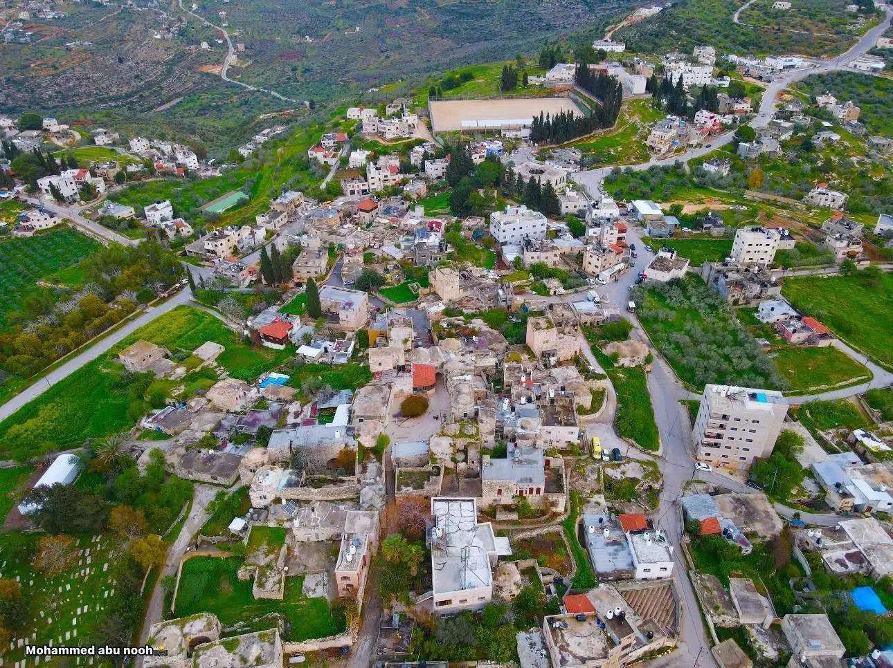
- تصوير جوي لبلدة دير غسانة شمال غرب مدينة رام الله قبل الافطار -- تصوير الأستاذ : محمد أبو نوح .

- تصوير جوي لبلدة دير غسانة شمال غرب مدينة رام الله قبل الافطار -- تصوير الأستاذ : محمد أبو نوح . #2

- تصوير جوي لبلدة دير غسانة شمال غرب مدينة رام الله قبل الافطار -- تصوير الأستاذ : محمد أبو نوح . #3

- تصوير جوي لبلدة دير غسانة شمال غرب مدينة رام الله قبل الافطار -- تصوير الأستاذ : محمد أبو نوح . #4

- تصوير جوي لبلدة دير غسانة شمال غرب مدينة رام الله قبل الافطار -- تصوير الأستاذ : محمد أبو نوح . #5

- تصوير جوي لبلدة دير غسانة شمال غرب مدينة رام الله قبل الافطار -- تصوير الأستاذ : محمد أبو نوح . #6
- منظر عام للبلدة القديمة -- تصوير الأستاذ : محمد أبو نوح

- بابور ابو سيف من المانيا ثم القدس والى دير غسانة -- محمد أبو نوح

- بابور ابو سيف من المانيا ثم القدس والى دير غسانة -- محمد أبو نوح #2

- بابور ابو سيف من المانيا ثم القدس والى دير غسانة -- محمد أبو نوح #3

- بابور ابو سيف من المانيا ثم القدس والى دير غسانة -- محمد أبو نوح #4

- بابور ابو سيف من المانيا ثم القدس والى دير غسانة -- محمد أبو نوح #5

- بابور ابو سيف من المانيا ثم القدس والى دير غسانة -- محمد أبو نوح #6

- الجبال والوديان الغربية -- محمد أبو نوح

- الجبال والوديان الغربية -- محمد أبو نوح #2

- الجبال والوديان الغربية -- محمد أبو نوح #3

- الجبال والوديان الغربية -- محمد أبو نوح #4

- صور لوادي الزرقاء العلوي دير غسانة ،، و وادي الليمون عابود -- حمود أبو نوح

- صور لوادي الزرقاء العلوي دير غسانة ،، و وادي الليمون عابود -- حمود أبو نوح #2

- صور لوادي الزرقاء العلوي دير غسانة ،، و وادي الليمون عابود -- حمود أبو نوح #3

- صور لوادي الزرقاء العلوي دير غسانة ،، و وادي الليمون عابود -- حمود أبو نوح #4

- صور لوادي الزرقاء العلوي دير غسانة ،، و وادي الليمون عابود -- حمود أبو نوح #5

- جولة ليلية في البلدة القديمة -- محمد أبو نوح

- جولة ليلية في البلدة القديمة -- محمد أبو نوح #2

- جولة ليلية في البلدة القديمة -- محمد أبو نوح #3

- جولة ليلية في البلدة القديمة -- محمد أبو نوح #4

- جولة ليلية في البلدة القديمة -- محمد أبو نوح #5

- جولة ليلية في البلدة القديمة -- محمد أبو نوح #6

- جولة ليلية في البلدة القديمة -- محمد أبو نوح #7

- شجر زيتون رومي -- يوسف عودة

- شجر زيتون رومي -- يوسف عودة #2

- شجر زيتون رومي -- يوسف عودة #3

- شجر زيتون رومي -- يوسف عودة #4

- شجر زيتون رومي -- يوسف عودة #5

- شجر زيتون رومي -- يوسف عودة #6

- جولة رائعة في الجبال والاودية المحيطة -- يوسف عودة

- جولة رائعة في الجبال والاودية المحيطة -- يوسف عودة #2

- جولة رائعة في الجبال والاودية المحيطة -- يوسف عودة #3

- جولة رائعة في الجبال والاودية المحيطة -- يوسف عودة #4

- جولة رائعة في الجبال والاودية المحيطة -- يوسف عودة #5

- جولة رائعة في الجبال والاودية المحيطة -- يوسف عودة #6

- جولة رائعة في الجبال والاودية المحيطة -- يوسف عودة #7

- جولة رائعة في الجبال والاودية المحيطة -- يوسف عودة #8

- جولة رائعة في الجبال والاودية المحيطة -- يوسف عودة #9

- جولة رائعة في الجبال والاودية المحيطة -- يوسف عودة #10

- جولة رائعة في الجبال والاودية المحيطة -- يوسف عودة #11

- واد صريدا -- يوسف عودة

- جولة رائعة في واد صريدا -- يوسف عودة

- جولة رائعة في واد صريدا -- يوسف عودة #2

- جولة رائعة في واد صريدا -- يوسف عودة #3

- جولة رائعة في واد صريدا -- يوسف عودة #4

- جولة رائعة في واد صريدا -- يوسف عودة #5

- جولة رائعة في واد صريدا -- يوسف عودة #6

- جولة رائعة في واد صريدا -- يوسف عودة #7

- جولة رائعة في واد صريدا -- يوسف عودة

- جولة رائعة في واد صريدا -- يوسف عودة #2

- جولة رائعة في واد صريدا -- يوسف عودة #3

- جولة رائعة في واد صريدا -- يوسف عودة #4

- جولة رائعة في واد صريدا -- يوسف عودة #5

- جولة رائعة في واد صريدا -- يوسف عودة #6

- جولة رائعة في واد صريدا -- يوسف عودة #7

- بيت قديم -- يوسف عودة

- مبنى قديم -- يوسف عودة

- بيت قديم -- يوسف عودة

- البلدة القديمة -- يوسف عودة

- البلدة القديمة -- يوسف عودة

- جولة رائعة في مقام المجدوب -- يوسف عودة

- جولة رائعة في مقام المجدوب -- يوسف عودة #2

- جولة رائعة في مقام المجدوب -- يوسف عودة #3

- جولة رائعة في مقام المجدوب -- يوسف عودة #4

- جولة رائعة في مقام المجدوب -- يوسف عودة #5

- جولة رائعة في مقام المجدوب -- يوسف عودة #6

- جولة رائعة في مقام المجدوب -- يوسف عودة #7

- جولة رائعة في مقام المجدوب -- يوسف عودة #8

- جولة رائعة في مقام المجدوب -- يوسف عودة #9

- جولة رائعة في مقام المجدوب -- يوسف عودة #10

- جولة رائعة في مقام المجدوب -- يوسف عودة #11

- عين الزرقا -- يوسف عودة

- عين الزرقا -- يوسف عودة #2

- عين الزرقا -- يوسف عودة #3

- عين الزرقا -- يوسف عودة #4

- عين الزرقا -- يوسف عودة #5

- عين الزرقا -- يوسف عودة #6

- عين الزرقا -- يوسف عودة #7

- البلدة القديمة -- يوسف عودة

- البلدة القديمة -- يوسف عودة
#2

- البلدة القديمة -- يوسف عودة
#3

- عين الجديدة -- يوسف عودة

- عين الجديدة -- يوسف عودة #2

- عين الجديدة -- يوسف عودة #3

- جبال دير غسانة -- يوسف عودة

- شجرة زيتون معمرة -- يوسف عودة

- احد بيوت القرية القديمة -- Yousif Odeh

- جولة رائعة في مقام ومنتزه الخواص -- Mohammad Abo Nouh

- جولة رائعة في مقام ومنتزه الخواص -- Mohammad Abo Nouh #2

- جولة رائعة في مقام ومنتزه الخواص -- Mohammad Abo Nouh #3

- جولة رائعة في مقام ومنتزه الخواص -- Mohammad Abo Nouh #4

- جولة رائعة في مقام ومنتزه الخواص -- Mohammad Abo Nouh #5

- جولة رائعة في مقام ومنتزه الخواص -- Mohammad Abo Nouh #6

- جولة رائعة في مقام ومنتزه الخواص -- Mohammad Abo Nouh #7

- جولة رائعة في مقام ومنتزه الخواص -- Mohammad Abo Nouh #8

- A Photograph of Ṣaleh al-Barghuthy's Mansion-- قصر صالح البرغوثي قبل الترميم

- منظر في الاودية المحيطة

- منظر عام للقرية يعود لوقت النكبة

- A rare tour of the village's old house in the 1980s was done by the Riwaq Center

- A rare tour of the village's old house in the 1980s was done by the Riwaq Center #2

- A rare tour of the village's old house in the 1980s was done by the Riwaq Center #3

- A rare tour of the village's old house in the 1980s was done by the Riwaq Center #4

- A rare tour of the village's old house in the 1980s was done by the Riwaq Center #5

- A rare tour of the village's old house in the 1980s was done by the Riwaq Center #6

- A rare tour of the village's old house in the 1980s was done by the Riwaq Center #7

- A rare tour of the village's old house in the 1980s was done by the Riwaq Center #8

- A rare tour of the village's old house in the 1980s was done by the Riwaq Center #9

- A rare tour of the village's old house in the 1980s was done by the Riwaq Center #10

- A rare tour of the village's old house in the 1980s was done by the Riwaq Center #11

- A rare tour of the village's old house in the 1980s was done by the Riwaq Center #12

- A rare tour of the village's old house in the 1980s was done by the Riwaq Center #13

- A rare tour of the village's old house in the 1980s was done by the Riwaq Center #14

- A rare tour of the village's old house in the 1980s was done by the Riwaq Center #15

- A rare tour of the village's old house in the 1980s was done by the Riwaq Center #16

- A rare tour of the village's old house in the 1980s was done by the Riwaq Center #17

- A rare tour of the village's old house in the 1980s was done by the Riwaq Center #18

- A rare tour of the village's old house in the 1980s was done by the Riwaq Center #19

- A rare tour of the village's old house in the 1980s was done by the Riwaq Center #20

- A rare tour of the village's old house in the 1980s was done by the Riwaq Center #21

- A rare tour of the village's old house in the 1980s was done by the Riwaq Center #22

- A rare tour of the village's old house in the 1980s was done by the Riwaq Center #23

- A rare tour of the village's old house in the 1980s was done by the Riwaq Center #24

- A rare tour of the village's old house in the 1980s was done by the Riwaq Center #25

- A rare tour of the village's old house in the 1980s was done by the Riwaq Center #26

- A rare tour of the village's old house in the 1980s was done by the Riwaq Center #27

- A rare tour of the village's old house in the 1980s was done by the Riwaq Center #28

- A rare tour of the village's old house in the 1980s was done by the Riwaq Center #29

- A rare tour of the village's old house in the 1980s was done by the Riwaq Center #30

- A rare tour of the village's old house in the 1980s was done by the Riwaq Center #31

- A rare tour of the village's old house in the 1980s was done by the Riwaq Center #32

- A rare tour of the village's old house in the 1980s was done by the Riwaq Center #33

- A rare tour of the village's old house in the 1980s was done by the Riwaq Center #34

- A rare tour of the village's old house in the 1980s was done by the Riwaq Center #35

- A rare tour of the village's old house in the 1980s was done by the Riwaq Center #36

- A rare tour of the village's old house in the 1980s was done by the Riwaq Center #37

- A rare tour of the village's old house in the 1980s was done by the Riwaq Center #38

- A rare tour of the village's old house in the 1980s was done by the Riwaq Center #39

- A rare tour of the village's old house in the 1980s was done by the Riwaq Center #40

- A rare tour of the village's old house in the 1980s was done by the Riwaq Center #41

- A rare tour of the village's old house in the 1980s was done by the Riwaq Center #42

- A rare tour of the village's old house in the 1980s was done by the Riwaq Center #43

- A rare tour of the village's old house in the 1980s was done by the Riwaq Center #44

- A rare tour of the village's old house in the 1980s was done by the Riwaq Center #45

- A rare tour of the village's old house in the 1980s was done by the Riwaq Center #46

- A rare tour of the village's old house in the 1980s was done by the Riwaq Center #47

- A rare tour of the village's old house in the 1980s was done by the Riwaq Center #48

- A rare tour of the village's old house in the 1980s was done by the Riwaq Center #49

- A rare tour of the village's old house in the 1980s was done by the Riwaq Center #50

- A rare tour of the village's old house in the 1980s was done by the Riwaq Center #51

- A rare tour of the village's old house in the 1980s was done by the Riwaq Center #52

- A rare tour of the village's old house in the 1980s was done by the Riwaq Center #53

- A rare tour of the village's old house in the 1980s was done by the Riwaq Center #54

- A rare tour of the village's old house in the 1980s was done by the Riwaq Center #55

- A rare tour of the village's old house in the 1980s was done by the Riwaq Center #56

- A rare tour of the village's old house in the 1980s was done by the Riwaq Center #57

- A rare tour of the village's old house in the 1980s was done by the Riwaq Center #58

- A rare tour of the village's old house in the 1980s was done by the Riwaq Center #59

- A rare tour of the village's old house in the 1980s was done by the Riwaq Center #60

- A rare tour of the village's old house in the 1980s was done by the Riwaq Center #61

- A rare tour of the village's old house in the 1980s was done by the Riwaq Center #62

- A rare tour of the village's old house in the 1980s was done by the Riwaq Center #63

- A rare tour of the village's old house in the 1980s was done by the Riwaq Center #64

- A rare tour of the village's old house in the 1980s was done by the Riwaq Center #65

- A rare tour of the village's old house in the 1980s was done by the Riwaq Center #66

- A rare tour of the village's old house in the 1980s was done by the Riwaq Center #67

- A rare tour of the village's old house in the 1980s was done by the Riwaq Center #68

- A rare tour of the village's old house in the 1980s was done by the Riwaq Center #69

- A rare tour of the village's old house in the 1980s was done by the Riwaq Center #70

- A rare tour of the village's old house in the 1980s was done by the Riwaq Center #71

- A rare tour of the village's old house in the 1980s was done by the Riwaq Center #72

- A rare tour of the village's old house in the 1980s was done by the Riwaq Center #73

- A rare tour of the village's old house in the 1980s was done by the Riwaq Center #74

- A rare tour of the village's old house in the 1980s was done by the Riwaq Center #75

- A rare tour of the village's old house in the 1980s was done by the Riwaq Center #76

- A rare tour of the village's old house in the 1980s was done by the Riwaq Center #77

- A rare tour of the village's old house in the 1980s was done by the Riwaq Center #78

- A rare tour of the village's old house (mostly in Salih al-Bargouthi Housh) in the 1980s was done by the Riwaq Center

- A rare tour of the village's old house (mostly in Salih al-Bargouthi Housh) in the 1980s was done by the Riwaq Center #2

- A rare tour of the village's old house (mostly in Salih al-Bargouthi Housh) in the 1980s was done by the Riwaq Center #3

- A rare tour of the village's old house (mostly in Salih al-Bargouthi Housh) in the 1980s was done by the Riwaq Center #4

- A rare tour of the village's old house (mostly in Salih al-Bargouthi Housh) in the 1980s was done by the Riwaq Center #5

- A rare tour of the village's old house (mostly in Salih al-Bargouthi Housh) in the 1980s was done by the Riwaq Center #6

- A rare tour of the village's old house (mostly in Salih al-Bargouthi Housh) in the 1980s was done by the Riwaq Center #7

- A rare tour of the village's old house (mostly in Salih al-Bargouthi Housh) in the 1980s was done by the Riwaq Center #8

- A rare tour of the village's old house (mostly in Salih al-Bargouthi Housh) in the 1980s was done by the Riwaq Center #9

- A rare tour of the village's old house (mostly in Salih al-Bargouthi Housh) in the 1980s was done by the Riwaq Center #10

- A rare tour of the village's old house (mostly in Salih al-Bargouthi Housh) in the 1980s was done by the Riwaq Center #11

- A rare tour of the village's old house (mostly in Salih al-Bargouthi Housh) in the 1980s was done by the Riwaq Center #12

- A rare tour of the village's old house (mostly in Salih al-Bargouthi Housh) in the 1980s was done by the Riwaq Center #13

- A rare tour of the village's old house (mostly in Salih al-Bargouthi Housh) in the 1980s was done by the Riwaq Center #14

- A rare tour of the village's old house (mostly in Salih al-Bargouthi Housh) in the 1980s was done by the Riwaq Center #15

- A rare tour of the village's old house (mostly in Salih al-Bargouthi Housh) in the 1980s was done by the Riwaq Center #16

- A rare tour of the village's old house (mostly in Salih al-Bargouthi Housh) in the 1980s was done by the Riwaq Center #17

- A rare tour of the village's old house (mostly in Salih al-Bargouthi Housh) in the 1980s was done by the Riwaq Center #18

- A rare tour of the village's old house (mostly in Salih al-Bargouthi Housh) in the 1980s was done by the Riwaq Center #19

- A rare tour of the village's old house (mostly in Salih al-Bargouthi Housh) in the 1980s was done by the Riwaq Center #20

- A rare tour of the village's old house (mostly in Salih al-Bargouthi Housh) in the 1980s was done by the Riwaq Center #21

- A rare tour of the village's old house (mostly in Salih al-Bargouthi Housh) in the 1980s was done by the Riwaq Center #22

- A rare tour of the village's old house (mostly in Salih al-Bargouthi Housh) in the 1980s was done by the Riwaq Center #23

- A rare tour of the village's old house (mostly in Salih al-Bargouthi Housh) in the 1980s was done by the Riwaq Center #24

- A rare tour of the village's old house (mostly in Salih al-Bargouthi Housh) in the 1980s was done by the Riwaq Center #25

- A rare tour of the village's old house (mostly in Salih al-Bargouthi Housh) in the 1980s was done by the Riwaq Center #26

- A rare tour of the village's old house (mostly in Salih al-Bargouthi Housh) in the 1980s was done by the Riwaq Center #27

- A rare tour of the village's old house (mostly in Salih al-Bargouthi Housh) in the 1980s was done by the Riwaq Center #28

- A rare tour of the village's old house (mostly in Salih al-Bargouthi Housh) in the 1980s was done by the Riwaq Center #29

- A rare tour of the village's old house (mostly in Salih al-Bargouthi Housh) in the 1980s was done by the Riwaq Center #30

- A rare tour of the village's old house (mostly in Salih al-Bargouthi Housh) in the 1980s was done by the Riwaq Center #31

- A rare tour of the village's old house (mostly in Salih al-Bargouthi Housh) in the 1980s was done by the Riwaq Center #32

- A rare tour of the village's old house (mostly in Salih al-Bargouthi Housh) in the 1980s was done by the Riwaq Center #33

- A rare tour of the village's old house (mostly in Shu'aybi's Housh) in the 1980s was done by the Riwaq Center

- A rare tour of the village's old house (mostly in Shu'aybi's Housh) in the 1980s was done by the Riwaq Center #2

- A rare tour of the village's old house (mostly in Shu'aybi's Housh) in the 1980s was done by the Riwaq Center #3

- A rare tour of the village's old house (mostly in Shu'aybi's Housh) in the 1980s was done by the Riwaq Center #4

- A rare tour of the village's old house (mostly in Shu'aybi's Housh) in the 1980s was done by the Riwaq Center #5

- A rare tour of the village's old house (mostly in Shu'aybi's Housh) in the 1980s was done by the Riwaq Center #6

- A rare tour of the village's old house (mostly in Shu'aybi's Housh) in the 1980s was done by the Riwaq Center #7

- A rare tour of the village's old house (mostly in Shu'aybi's Housh) in the 1980s was done by the Riwaq Center #8

- A rare tour of the village's old house (mostly in Shu'aybi's Housh) in the 1980s was done by the Riwaq Center #9

- A rare tour of the village's old house (mostly in Shu'aybi's Housh) in the 1980s was done by the Riwaq Center #10

- A rare tour of the village's old house (mostly in Shu'aybi's Housh) in the 1980s was done by the Riwaq Center #11

- A rare tour of the village's old house (mostly in Shu'aybi's Housh) in the 1980s was done by the Riwaq Center #12

- A rare tour of the village's old house (mostly in Shu'aybi's Housh) in the 1980s was done by the Riwaq Center #13

- A rare tour of the village's old house (mostly in Shu'aybi's Housh) in the 1980s was done by the Riwaq Center #14

- A rare tour of the village's old house (mostly in Shu'aybi's Housh) in the 1980s was done by the Riwaq Center #15

- A rare tour of the village's old house (mostly in Shu'aybi's Housh) in the 1980s was done by the Riwaq Center #16

- A rare tour of the village's old house (mostly in Shu'aybi's Housh) in the 1980s was done by the Riwaq Center #17

- A rare tour of the village's old house (mostly in Shu'aybi's Housh) in the 1980s was done by the Riwaq Center #18

- A rare tour of the village's old house (mostly in Shu'aybi's Housh) in the 1980s was done by the Riwaq Center #19

- A rare tour of the village's old house (mostly in Shu'aybi's Housh) in the 1980s was done by the Riwaq Center #20

- A rare tour of the village's old house (mostly in Shu'aybi's Housh) in the 1980s was done by the Riwaq Center #21

- A rare tour of the village's old house (mostly in Shu'aybi's Housh) in the 1980s was done by the Riwaq Center #22

- A rare tour of the village's old house (mostly in Shu'aybi's Housh) in the 1980s was done by the Riwaq Center #23

- A rare tour of the village's old house (mostly in Shu'aybi's Housh) in the 1980s was done by the Riwaq Center #24

- A rare tour of the village's old house (mostly in Shu'aybi's Housh) in the 1980s was done by the Riwaq Center #25

- A rare tour of the village's old house (mostly in Shu'aybi's Housh) in the 1980s was done by the Riwaq Center #26

- A rare tour of the village's old house (mostly in Shu'aybi's Housh) in the 1980s was done by the Riwaq Center #27

- A rare tour of the village's old house (mostly in Shu'aybi's Housh) in the 1980s was done by the Riwaq Center #28

- صورة نادرة لصندوق العروس

- الجامع الجديد في ثمانينيات القرن الماضي

- General view of the village taken in the 1980s by Riwaq Center

- General view of the village taken in the 1980s by Riwaq Center #2

- General view of the village taken in the 1980s by Riwaq Center #3

- General view of the village taken in the 1980s by Riwaq Center #4

- General view of the village taken in the 1980s by Riwaq Center #5

- صورة لعائلة اخذت في ثمانينيات القرن الماضي

- صور لمقام القواس اخذت في ثمانينيات القرن الماضي -- مؤسسة رواق

- صور لمقام القواس اخذت في ثمانينيات القرن الماضي -- مؤسسة رواق #2

- صور لمقام القواس اخذت في ثمانينيات القرن الماضي -- مؤسسة رواق #3

- صور لمقام القواس اخذت في ثمانينيات القرن الماضي -- مؤسسة رواق #4

- صور لمقام القواس اخذت في ثمانينيات القرن الماضي -- مؤسسة رواق #5

- صور لمقام القواس اخذت في ثمانينيات القرن الماضي -- مؤسسة رواق #6

- صور في مدرسة محو الامية في ثمانينيات القرن الماضي -- مؤسسة رواق

- صور في مدرسة محو الامية في ثمانينيات القرن الماضي -- مؤسسة رواق #2

- صور في مدرسة محو الامية في ثمانينيات القرن الماضي -- مؤسسة رواق #3

- صور في مدرسة محو الامية في ثمانينيات القرن الماضي -- مؤسسة رواق #4

- Baking in the Taboun -- 1980s

Want to browse more? 80,000 pictures were grouped in these gallaries:
| Display Name | Clan/Hamolah | Country of Residence |
| yazan bargouthi | bargouthi | - |
| mohammad shoiby | الشعيبي | رام الله, ديرغسانة |
| اشرف البرغوثي | - | - |
| أبو أحمد | البرغوثي | - |
| ملاذ | البرغوثي | الرياض |
| شعيبي | - | رام الله |
| aalbarghothi | البرغوثي | الرياض |
| وائل المهتدي | - | الاردن |
| منتصر النوباني | - | Abu Dhabi |
| nagham rabi | - | - |
| mony | - | - |
| Khaled El Sala | Sala | Khobar, Saudi Arabia |
- تصوير جويي رائع لدير غسانة Duration: 9 min 50 sec
- وثيق لأحد الخرب الأثرية الجميلة"خربة البلاطة " في واد صريدة Duration: 5 min 34 sec
 Fake Valor: Why Did Zionist Jews Hoist Nazis Flag on Their Ships in the 1930s?
What is new?
-
Facts About Oct. 7th Gaza Raid
-
Remined Us Please: Who Did Rape Whom? Was it Palestinians who raped Israelis? Or, was the other way around? You'll be the judge
-
When Prof. Edward Said was invited to debate Bibi Netanyahu in the 1980s, watch what happened!
-
Ezra Klein of the NY Times on the "Jewish Race".
-
Abusing Blood Libel!
-
How and why Israeli Jewry has become the most hated cult?
-
Did Israeli Soldiers Activate The Hannibal Direective On Oct. 7th? You Be The Judge
-
Zionist FAQ: Isn't it true that Palestinians don't want peace? Palestinians never accepted the two-state solution
- Facts about Haavara (Transfer) Agreement between Ben-Gurion & Hitler
-
Haavara FAQs: Why Did Zionist Jews Hoist Nazis' Flags on Their Ships in the 1930s?
- Haavara FAQs: When Chaim Weizmann met FDR in mid-1943, why was he silent about rescuing European Jewry?
-
Dear ChatGPT: How did Palestinians resist Napoleon's invasion of their country in 1799?
-
Dear ChatGPT: Gaza had a vibrant Jewish community in the mid-17th century. What happened to them?
-
Dear ChatGPT: Why did the Jewish Agency suppress news of the Holocaust during WWII?
-
Video Playlist: Jews share their DNA tests to end the conflict for good.
-
A Tale of Two Conflicts: Examining the Definition of Genocide
-
Prof. Abraham Polak And The Suppressed History of the Khazars and European Jewry
-
How Ronald Reagan would have framed the genocide in Gaza if he were still alive?
-
Haavara FAQs: Let us do the math: how many German Jews did The Haavara Agreement save?
-
Zionist FAQs: The Hebron Massacre of 1929, "clearly proves" that Palestinians are antisemitic, how could you deny it?
-
Zionist FAQs: Why Anti-Zionist Is Not Antisemitism?
-
Zionist FAQs: Isn't it true that the KGB created Palestinian Nationalism in the early 1960s?
- Zionist FAQs: Muslims are killing Muslims all the time; why are Israeli Jews being singled out in the media?
- Zionist FAQs: How is Israel an apartheid state when 20% of its citizens are Arabs who enjoy full rights?
-
Haavara FAQs: Why Did Dorothy Thompson Flip From A Zionist Advocate to A Silenced Dissenter?
-
Haavara FAQs: Analysis of Herzl's Uganda Scheme and how it could have saved millions of Jews.
-
Haavara FAQs: Why did Hayim Greenberg describe American Jewry as "morally bankrupt" in early 1943?
-
Haavara FAQs: What if the Evian Conference was a resounding success? What would have been the impact of saving European Jewry on Zionism?
- Haavara FAQs: What if the six million were saved, how that would have impacted the Zionist project?
-
Haavara FAQs: How did Zionist leaders react when Europe's Jews lingered in the DP camps after WWII ended?
-
Why does the American Jewish community repeat lies that David Ben-Gurion had debunked before he died?
-
Who has the power to rename the Tatar/Khazar Gene Marker to Jewish IV?
-
Zionist FAQs: Why won't Egypt, Syria, and Jordan take their people back? Jews are indigenous to Palestine, and Arabs immigrated after Jews developed the country. Arabs should leave.
-
Haavara FAQs: Did Hitler and the Nazis conflate between Judaism and Zionist? If that wasn't case, then why?
-
Haavara FAQs: Winston Churchill and antisemitism, a collection of articles written Churchill.
-
Haavara FAQs: Broken by country, how many Jews survived vs. killed during the Holocaust?
-
Haavara FAQs: Why did European Jews vote with their feet and to immigrated to the Americas, not Palestine, after WWII?
-
Watch this American Jewish Girl describing Israeli Jews' cognitive dissonance like no other in under two minutes
-
Haavara FAQs: When the Nazis went out of their way to hide the Holocaust, Israeli Jews did the exact opposite by broadcasting their genocide of Gazans. But why?
-
Haavara FAQs: How Zionist Jews went out of their to show their appreciation to Nazism and Fascism?
- Haavara FAQs: Why Zionist leaders were against bombing the death camps & the Railroads leading to them?
-
Haavara FAQs: Hitler's message to the British and American people: If Jews are such noble citizens and you care about them, how come you're not letting them in? I will gladly ship them to you at my expense, even on luxury liners!
-
A shortlist of Zionist and Israeli false flag operations in the name Jews.
-
The Most Moral Army
- The Land of Kapos (Israel): Where the brave are boycotted and Kapos walk free.
- Why did early Zionists often named their communal enterprises "colonial"?
- Zionist Relations with Nazi Germany by Faris Glubb
-
Two NY Times advertisements by Zionists in the early 1943 that exposes Zionists' treason at the height of the calamity
- Facts Not Lies about the Palestinian-Israeli Conflict.
- Site's pictures have been categorized
- Campgain Against Lice
- A Survey of Palestine, the official source about Palestine before Nakba produced by the British Mandate; over 1200 pages.
- Satellite View & Google Earth: Over 6,000 placemarks identifying all destroyed towns, W. Bank & Gaza Strip Towns, & refugee camps.
- PalestineRemembered.com and its Nakba Oral History Project were featured on al-Jazeera Satellite TV.
- Nakba Oral History Video Podcast:
 Over 700 Oral History interviews (including 3,500+ hours of recording) can be viewed online.
 - Palestine Village Statistics Project
- Gaza Jail Break
- النسخة العربية للموقع الان متوفرة
- Videos: Documenting the destroyed villages in video: Tracing all that remains since Nakba.
- Videos: Responding to Zionist Propaganda
- Interview: The ethnic cleansing of Palestine: George Galloway interviews Israeli Historian Ilan Pappe.
- For Palestinians, memory matters. It provides a blueprint for their future By George Bisharat.
- Zionist FAQ now available in Hebrew שאלות שציונים שואלים, עכשיו בעברית
- Video: The Stephen Walt and John Mearsheimer report on the influence of the Israel Lobby on U.S. Foreign Policy
- The Palestinian-Israeli conflict for beginners
