| PalestineRemembered | About Us | Oral History | العربية | |
| Pictures | Zionist FAQs | Haavara | Maps | |
| Search |
| Camps |
| Districts |
| Acre |
| Baysan |
| Beersheba |
| Bethlehem |
| Gaza |
| Haifa |
| Hebron |
| Jaffa |
| Jericho |
| Jerusalem |
| Jinin |
| Nablus |
| Nazareth |
| Ramallah |
| al-Ramla |
| Safad |
| Tiberias |
| Tulkarm |
| Donate |
| Contact |
| Profile |
| Videos |
Welcome To Kafr Qasem - كفر قاسم (כפר קאסם)
|
District of Tulkarm
Occupied days ago |
العربية Google Earth |
 |
Gallery (34) |
- Statistics & Facts
-
Before & After

- Satellite View
- Articles 3
- Pictures 34
- Aerial Views 1
- Mayrters & Prisoners 7
- Oral History 2
- Members 2
- Wikipedia
- Videos 4
- Guest Book 3
- Links
| Statistic & Fact | Value | ||||||||||||||||
| Distance From District | 23 km south of Tulkarm | ||||||||||||||||
| Elevation | 125 meters | ||||||||||||||||
| Before & After Nakba, Click Map For Details |
|||||||||||||||||

|
|||||||||||||||||
| Land Ownership |
**Town Lands' Demarcation Maps |
||||||||||||||||
| Land Usage As of 1945 |
|
||||||||||||||||
| Usurped Land as of 1972 | 7,865 Dunums | ||||||||||||||||
| Usurped Land as of 1962 | 7,799 Dunums | ||||||||||||||||
| Lands usurped within armistice area | 12,260 Dunums | ||||||||||||||||
| Population |
|
||||||||||||||||
| Near By Towns |
|||||||||||||||||
|
|||||||||||||||||
| Featured Video | |||||||||||||||||
| Related Maps | Town Lands' Demarcation Maps خرائط للقضاء توضح حدود القرى والاودية View from satellite Town's map on MapQuest Help us map this town at WikiMapia |
||||||||||||||||
| Related Links | Wikipedia's Page Facebook Page Google Search Google For Images Google For Videos في كتاب بلادنا فلسطين المزيد من موقع هوية |
||||||||||||||||
- في الذكرى ال50 لمجزرة كفر قاسم- اطفال مع نظرة الى مستقبل افضل - امام متحف الشهداء - تصوير الفنان سلام ذياب
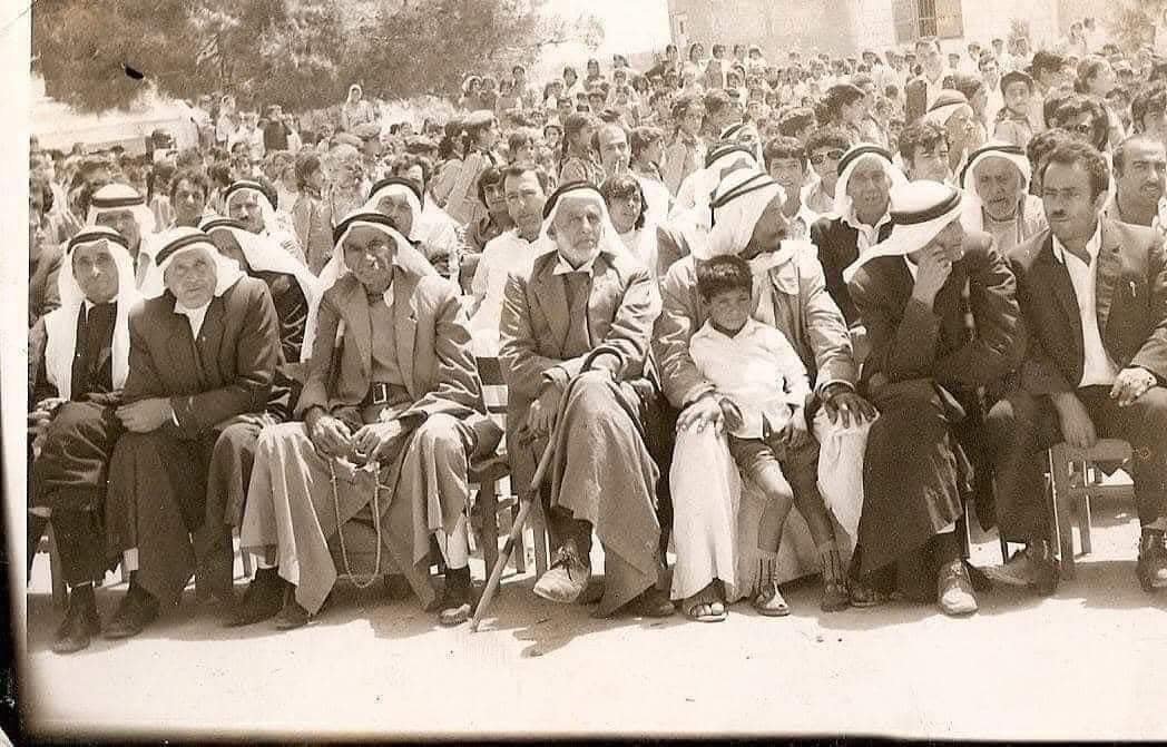
Posted by salam diab 3 - A village scene taken soon after King Abdullah the 1st handed over the little triangle villages in Rhodos, 1949. The king paid for this withhis life few months after.

- في الذكرى ال50 لمجزرة كفر قاسم- بوستر المجزرة- تصوير الفنان سلام ذياب

Posted by salam diab - في الذكرى ال50 لمجزرة كفر قاسم- النصب التذكاري القديم للمجزرة - تصوير الفنان سلام ذياب 2006

Posted by salam diab - في الذكرى ال50 لمجزرة كفر قاسم- النصب التذكاري الجديد للمجزرة من تصميم الفنان والمهندس ابراهيم حجازي - عن رابطة الفنانين التشكيليين العرب

Posted by salam diab 1 - في الذكرى ال50 لمجزرة كفر قاسم- اطفال كفر قاسم امام النصب التذكاري الجديد للمجزرة - تصوير الفنان سلام ذياب 2006

Posted by salam diab - في الذكرى ال50 لمجزرة كفر قاسم- اكليل زهور من رابطة ابداع في الجليل على النصب التذكاري الجديد للمجزرة - تصوير الفنان سلام ذياب 2006

Posted by salam diab - في الذكرى ال50 لمجزرة كفر قاسم- في يوم افتتاح متحف الشهداء - تصوير الفنان سلام ذياب 2006

Posted by salam diab - في الذكرى ال50 لمجزرة كفر قاسم- اب يشرح لابنه الطفل قصة المجزرة داخل متحف الشهداء - تصوير الفنان سلام ذياب 2006

Posted by salam diab - في الذكرى ال50 لمجزرة كفر قاسم- صورة احدى شهداء المجزرة ال49 - داخل متحف الشهداء - تصوير الفنان سلام ذياب 2006

Posted by salam diab - في الذكرى ال50 لمجزرة كفر قاسم- صورة لاحدى شهيدات المجزرة ال49 - داخل متحف الشهداء - تصوير الفنان سلام ذياب 2006

Posted by salam diab - في الذكرى ال50 لمجزرة كفر قاسم- صورة لطفلة عمرها 14 عاما- احدى شهيدات المجزرة ال49 - داخل متحف الشهداء - تصوير الفنان سلام ذياب 2006

Posted by salam diab - في الذكرى ال50 لمجزرة كفر قاسم- صورة للطفل محمد سليم صرصور عمره 15 عاما- احد شهداء المجزرة ال49 - داخل متحف الشهداء - تصوير الفنان سلام ذياب 2006

Posted by salam diab - في الذكرى ال50 لمجزرة كفر قاسم- رسمة توضح انعدام العدل في الغرامة التى فرضت على قاتلي شهداء المجزرة ال49 -من لوحات متحف الشهداء - تصوير الفنان سلام ذياب 2006

Posted by salam diab - في الذكرى ال50 لمجزرة كفر قاسم- مذكرة توفيق طوبي من تاريخ 23.11.1956 يشرح بها القصه كما حدثت - لكي لا ننسى - من وثائق متحف الشهداء - تصوير الفنان سلام ذياب 2006

Posted by salam diab - في الذكرى ال50 لمجزرة كفر قاسم- اللوحة الفائزة بمسابقة الشهيد - للفنانه عضورة رابطة ابداع -صبحية حسن من نحف- الجليل- منمجموعة متحف الشهداء - تصوير الفنان سلام ذياب 2006

Posted by salam diab - في الذكرى ال50 لمجزرة كفر قاسم- لوحة نحاسية - للفنان القدير ابن مدينة عكا - جبر حمدان - من مجموعة متحف الشهداء - تصوير الفنان سلام ذياب 2006

Posted by salam diab - بوستر مذبحة كفر قاسم - المعلق في بيت جدي سليمان كنعان في طمرة- تصوير الفنان سلام منير ذياب 2006

Posted by salam diab - منظر من الجنوب-1970
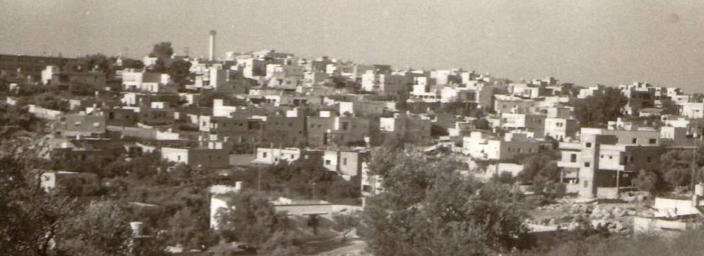
Posted by Ghanem Mustafa 1 - كفر قاسم من الغرب

Posted by ابو الثائر - صوره من الجهه الغربيه للبلده

Posted by ابو الثائر - المدخل الغربي لكفر قاسم ، يوم الخميس 20رمضان 1403،30-6-1983

Posted by Abu Najm Bassel - أسماء شهداء مجزرة كفر قاسم على مدخل القرية الغربي ،في 20رمضان 1403 30-06-1983

Posted by Abu Najm Bassel - السهل مقابل الشارع المؤدي الى كفر قاسم ،الخميس 20 رمضان 1403 30-06-1983

Posted by Abu Najm Bassel - منظر عام

- كفر قاسم من سنيريا

- الجناة ---- فبعد الضغط الجماهيري جرت محاكمة 11 متهمًا بارتكاب المجزرة ( يظهرون بالصورة أدناه ) وهم : شموئيل ملينكي ، يساخار شدمي ، جبرائيل دهان ، شالوم عوفر ، مخلوف حروّش ، إلياهو أبراهام ، جبرائيل عولئيل ، ألبرت فحيما ، أدمون نحماني ، إسماعيل عبد الرحمن ، زكريا شعبان ، ودانئيل سمينيتش . برأت المحكمة ساحة ثلاثة من المتهمين وحكمت على ملينكي بالسجن 17 عامًا وجبرائيل دهان ب15 عامًا والباقون بمدد تراوحت بين 5-7 سنوات . لم ينه أي منهم مدة محكوميته ولم تعرقل الأحكام تقدمهم وترقيتهم بالوظائف لاحقًا . أما قمة السخرية فكانت العقاب الذي فرض على قائد المنطقة يساخار شدمي الذي بلغ قرشاً واحداً (عشر بروطات ) فذهب هذا الحكم مثلاً للعقاب البخس . فقيل " قرش شدمي " لمهازل القضاء والاستهتار بحياة البشر ---
بروفيسور مصطفى كبها

- مجدل يافا

- من مدينة كفر قاسم
صورة تعود لسبعينيات القرن الماضي
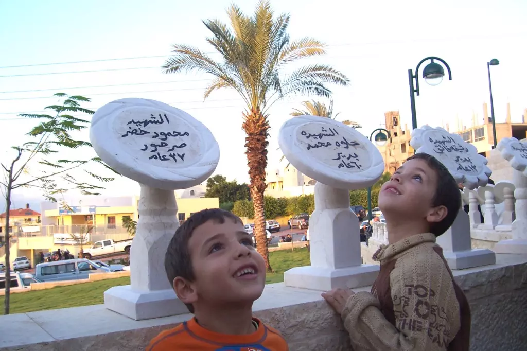
- شهداء مجزرة كفر قاسم -- ٢٩ تشرين أول عام ١٩٥٦

- خارطة تُظهِر الحدود والطرق بأنواعها والأماكن المقدسة والطبيعة الطوبغرافية من تلال وسهول ومنحدرات والتشكيلة الطبيعية للأرض وأنواع المزروعات. نُشرت الخريطة فترة الانتداب البريطاني، تم إضافة تعديلات عليها من قِبَل خدمة الخرائط والصور التابعة للقوات العسكرية الاسرائيلية فترة الأربعينيات.

- طلب رخصة بناء للمواطن سليم عبد صالح حمدان-كفر قاسم
-تاريخ الوثيقة: 10/10/1947

- العنوان في أعلى الصورة مكتوب بالعبرية:
"محاكمة المتهمين في مجزرة كفر قاسم". -- المزيد في قسم التعليقات

1 - طلب رخصة بناء للمواطن عبد الغافر حمدان-كفر قاسم
-تاريخ الوثيقة:
07/04/1946

Want to browse more? 80,000 pictures were grouped in these gallaries:
- في الذكرى ال50 لمجزرة كفر قاسم- اطفال مع نظرة الى مستقبل افضل - امام متحف الشهداء - تصوير الفنان سلام ذياب
Posted by salam diab 3 - في الذكرى ال50 لمجزرة كفر قاسم- النصب التذكاري القديم للمجزرة - تصوير الفنان سلام ذياب 2006
Posted by salam diab - في الذكرى ال50 لمجزرة كفر قاسم- في يوم افتتاح متحف الشهداء - تصوير الفنان سلام ذياب 2006
Posted by salam diab - في الذكرى ال50 لمجزرة كفر قاسم- صورة لاحدى شهيدات المجزرة ال49 - داخل متحف الشهداء - تصوير الفنان سلام ذياب 2006
Posted by salam diab - في الذكرى ال50 لمجزرة كفر قاسم- صورة لطفلة عمرها 14 عاما- احدى شهيدات المجزرة ال49 - داخل متحف الشهداء - تصوير الفنان سلام ذياب 2006
Posted by salam diab - في الذكرى ال50 لمجزرة كفر قاسم- صورة للطفل محمد سليم صرصور عمره 15 عاما- احد شهداء المجزرة ال49 - داخل متحف الشهداء - تصوير الفنان سلام ذياب 2006
Posted by salam diab - في الذكرى ال50 لمجزرة كفر قاسم- مذكرة توفيق طوبي من تاريخ 23.11.1956 يشرح بها القصه كما حدثت - لكي لا ننسى - من وثائق متحف الشهداء - تصوير الفنان سلام ذياب 2006
Posted by salam diab
| Display Name | Clan/Hamolah | Country of Residence |
| khalid refat sarsour | - | كفر قاسم, الداخل المحتل |
| Watany Ben Jamil Freij | - | - |
- حلوة يا دنيا - كفر قاسم - فلسطين Duration: 17 min 37 sec
- وثائقي عن مجزرة كفر قاسم Duration: 21 min 35 sec
- Kafr Qasim Massacre case: Military Court decision granted Duration: 5 min 6 sec
- حكاية بلد قرية كفر قاسم إخراج رولا جمالية Duration: 23 min 59 sec
No links have been shared yet, be free to the first to share the first link.
 Fake Valor: Why Did Zionist Jews Hoist Nazis Flag on Their Ships in the 1930s?
What is new?
-
Facts About Oct. 7th Gaza Raid
-
Remined Us Please: Who Did Rape Whom? Was it Palestinians who raped Israelis? Or, was the other way around? You'll be the judge
-
When Prof. Edward Said was invited to debate Bibi Netanyahu in the 1980s, watch what happened!
-
Ezra Klein of the NY Times on the "Jewish Race".
-
Abusing Blood Libel!
-
How and why Israeli Jewry has become the most hated cult?
-
Did Israeli Soldiers Activate The Hannibal Direective On Oct. 7th? You Be The Judge
-
Zionist FAQ: Isn't it true that Palestinians don't want peace? Palestinians never accepted the two-state solution
- Facts about Haavara (Transfer) Agreement between Ben-Gurion & Hitler
-
Haavara FAQs: Why Did Zionist Jews Hoist Nazis' Flags on Their Ships in the 1930s?
- Haavara FAQs: When Chaim Weizmann met FDR in mid-1943, why was he silent about rescuing European Jewry?
-
Dear ChatGPT: How did Palestinians resist Napoleon's invasion of their country in 1799?
-
Dear ChatGPT: Gaza had a vibrant Jewish community in the mid-17th century. What happened to them?
-
Dear ChatGPT: Why did the Jewish Agency suppress news of the Holocaust during WWII?
-
Video Playlist: Jews share their DNA tests to end the conflict for good.
-
A Tale of Two Conflicts: Examining the Definition of Genocide
-
Prof. Abraham Polak And The Suppressed History of the Khazars and European Jewry
-
How Ronald Reagan would have framed the genocide in Gaza if he were still alive?
-
Haavara FAQs: Let us do the math: how many German Jews did The Haavara Agreement save?
-
Zionist FAQs: The Hebron Massacre of 1929, "clearly proves" that Palestinians are antisemitic, how could you deny it?
-
Zionist FAQs: Why Anti-Zionist Is Not Antisemitism?
-
Zionist FAQs: Isn't it true that the KGB created Palestinian Nationalism in the early 1960s?
- Zionist FAQs: Muslims are killing Muslims all the time; why are Israeli Jews being singled out in the media?
- Zionist FAQs: How is Israel an apartheid state when 20% of its citizens are Arabs who enjoy full rights?
-
Haavara FAQs: Why Did Dorothy Thompson Flip From A Zionist Advocate to A Silenced Dissenter?
-
Haavara FAQs: Analysis of Herzl's Uganda Scheme and how it could have saved millions of Jews.
-
Haavara FAQs: Why did Hayim Greenberg describe American Jewry as "morally bankrupt" in early 1943?
-
Haavara FAQs: What if the Evian Conference was a resounding success? What would have been the impact of saving European Jewry on Zionism?
- Haavara FAQs: What if the six million were saved, how that would have impacted the Zionist project?
-
Haavara FAQs: How did Zionist leaders react when Europe's Jews lingered in the DP camps after WWII ended?
-
Why does the American Jewish community repeat lies that David Ben-Gurion had debunked before he died?
-
Who has the power to rename the Tatar/Khazar Gene Marker to Jewish IV?
-
Zionist FAQs: Why won't Egypt, Syria, and Jordan take their people back? Jews are indigenous to Palestine, and Arabs immigrated after Jews developed the country. Arabs should leave.
-
Haavara FAQs: Did Hitler and the Nazis conflate between Judaism and Zionist? If that wasn't case, then why?
-
Haavara FAQs: Winston Churchill and antisemitism, a collection of articles written Churchill.
-
Haavara FAQs: Broken by country, how many Jews survived vs. killed during the Holocaust?
-
Haavara FAQs: Why did European Jews vote with their feet and to immigrated to the Americas, not Palestine, after WWII?
-
Watch this American Jewish Girl describing Israeli Jews' cognitive dissonance like no other in under two minutes
-
Haavara FAQs: When the Nazis went out of their way to hide the Holocaust, Israeli Jews did the exact opposite by broadcasting their genocide of Gazans. But why?
-
Haavara FAQs: How Zionist Jews went out of their to show their appreciation to Nazism and Fascism?
- Haavara FAQs: Why Zionist leaders were against bombing the death camps & the Railroads leading to them?
-
Haavara FAQs: Hitler's message to the British and American people: If Jews are such noble citizens and you care about them, how come you're not letting them in? I will gladly ship them to you at my expense, even on luxury liners!
-
A shortlist of Zionist and Israeli false flag operations in the name Jews.
-
The Most Moral Army
- The Land of Kapos (Israel): Where the brave are boycotted and Kapos walk free.
- Why did early Zionists often named their communal enterprises "colonial"?
- Zionist Relations with Nazi Germany by Faris Glubb
-
Two NY Times advertisements by Zionists in the early 1943 that exposes Zionists' treason at the height of the calamity
- Facts Not Lies about the Palestinian-Israeli Conflict.
- Site's pictures have been categorized
- Campgain Against Lice
- A Survey of Palestine, the official source about Palestine before Nakba produced by the British Mandate; over 1200 pages.
- Satellite View & Google Earth: Over 6,000 placemarks identifying all destroyed towns, W. Bank & Gaza Strip Towns, & refugee camps.
- PalestineRemembered.com and its Nakba Oral History Project were featured on al-Jazeera Satellite TV.
- Nakba Oral History Video Podcast:
 Over 700 Oral History interviews (including 3,500+ hours of recording) can be viewed online.
 - Palestine Village Statistics Project
- Gaza Jail Break
- النسخة العربية للموقع الان متوفرة
- Videos: Documenting the destroyed villages in video: Tracing all that remains since Nakba.
- Videos: Responding to Zionist Propaganda
- Interview: The ethnic cleansing of Palestine: George Galloway interviews Israeli Historian Ilan Pappe.
- For Palestinians, memory matters. It provides a blueprint for their future By George Bisharat.
- Zionist FAQ now available in Hebrew שאלות שציונים שואלים, עכשיו בעברית
- Video: The Stephen Walt and John Mearsheimer report on the influence of the Israel Lobby on U.S. Foreign Policy
- The Palestinian-Israeli conflict for beginners
