| PalestineRemembered | About Us | Oral History | العربية | |
| Pictures | Zionist FAQs | Haavara | Maps | |
| Search |
| Camps |
| Districts |
| Acre |
| Baysan |
| Beersheba |
| Bethlehem |
| Gaza |
| Haifa |
| Hebron |
| Jaffa |
| Jericho |
| Jerusalem |
| Jinin |
| Nablus |
| Nazareth |
| Ramallah |
| al-Ramla |
| Safad |
| Tiberias |
| Tulkarm |
| Donate |
| Contact |
| Profile |
| Videos |
Welcome To al-Ram - الرام (א-ראם)
|
District of Jerusalem
Occupied days ago |
العربية Google Earth |
 |
Gallery (174) |
- Statistics & Facts
-
Before & After

- Satellite View
- Articles 19
- Pictures 174
- Members 3
- Families
- Wikipedia
- ARIJ Guide
- Videos 2
- Guest Book 1
- Links
| Statistic & Fact | Value | ||||||||||||||||||||
| Distance From District | 7 km north of Jerusalem | ||||||||||||||||||||
| Elevation | 792 meters | ||||||||||||||||||||
| Before & After Nakba, Click Map For Details |
|||||||||||||||||||||

|
|||||||||||||||||||||
| Land Ownership |
**Town Lands' Demarcation Maps |
||||||||||||||||||||
| Land Usage As of 1945 |
|
||||||||||||||||||||
| Population |
|
||||||||||||||||||||
| Near By Towns |
|||||||||||||||||||||
|
|||||||||||||||||||||
| Featured Video | |||||||||||||||||||||
| ARIJ Guide | |||||||||||||||||||||
3.

4. 
5. 
6. 
7. 
8. 
9. 
10. 
11. 
12. 
13. 
14. 
15. 
16. 
17. 
18. 
19. 
20. 
21. 
22. 
23. 
24. 
25. 
26. 
Click here to browse online. |
|||||||||||||||||||||
| Related Maps | Town Lands' Demarcation Maps خرائط للقضاء توضح حدود القرى والاودية View from satellite Town's map on MapQuest Help us map this town at WikiMapia |
||||||||||||||||||||
| Related Links | Wikipedia's Page Facebook Page ARIJ Guide Google Search Google For Images Google For Videos في كتاب بلادنا فلسطين دليل أريج المزيد من موقع هوية |
||||||||||||||||||||
- A Joint March of Palestinians and Israelis in Ar-Ram.
- Israeli forces kidnap 3 in Al-Ram town invasion.
- Israeli Family Rescued By Palestinian Refugees in Al-Ram.
- Home Demolitions: Nazati and Taghrite Z. Abed J. family in the Beqa'a Valley.
- United Against Ghettozation of Ar-Ram - Occupation Forces challenged by Mass Protest.
- The Apartheid Wall and Ghettos in Ar-Ram.
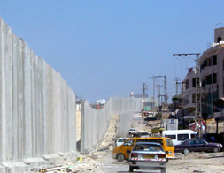
- Occupation Forces Erecting the Apartheid Wall in Ar-Ram, Jerusalem-Ramallah Road
- Occupation Forces Prevent the People of Tulkarem from Participating in Ar-Ram Protest Against the Apartheid Wall.
- Abu Saher: "A Palestinian in Jerusalem is Chased by the Occupation..."
- Solidarity with the Actions Taking Place NOW against the Apartheid Wall in Jerusalem.
- Ar-Ram Protest Against Apartheid Wall.
- Palestinians Resist Racist Zionism in Ar-Ram and Say No to the Apartheid Wall.
- The Apartheid Wall in Ar Ram Reinforces Zionist Apartheid.
- Demonstration Against the Apartheid Wall in Ar-Ram on Naksa Day.
- Ar-Ram: A Ghetto for Sixty Thousand People.
- Mass Demonstration on Naksa Day Against the Apartheid Wall in Ar-Ram.
- Construction Starts on the Apartheid Wall in Ar-Ram Area.
- Another Palestinian Ghetto in East Jerusalem: Israel Closes the Segregation Wall in Al-Ram.
- The Wall is slowly strangling the economic and social fabric of Al Ram.
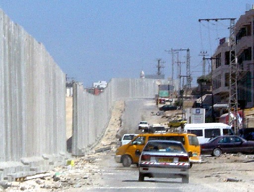
- Ar-Ram, General View #1
Posted by Ramy Nabil Abdeljabbar - The Wall in al-Ram
Posted by Ramy Nabil Abdeljabbar - The Wall in al-Ram

Posted by Ramy Nabil Abdeljabbar - The Wall in al-Ram
Posted by Ramy Nabil Abdeljabbar - The Wall in al-Ram

Posted by Ramy Nabil Abdeljabbar - The Wall in al-Ram
Posted by Ramy Nabil Abdeljabbar - The Wall in al-Ram
Posted by Ramy Nabil Abdeljabbar - The Wall in al-Ram
Posted by Ramy Nabil Abdeljabbar - The Wall in al-Ram
Posted by Ramy Nabil Abdeljabbar - The Wall in al-Ram
Posted by Ramy Nabil Abdeljabbar - The Wall in al-Ram
Posted by Ramy Nabil Abdeljabbar - The Wall in al-Ram
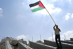
Posted by Ramy Nabil Abdeljabbar - A young Palestinian man waves a Palestinian flag atop the blocks waiting to be erected along the roadway from Jerusalem to Ramallah.
Posted by Ramy Nabil Abdeljabbar - Demonstrators stand just out reach of an Occupation water cannon in the main street of Ar Ram.

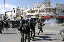
Posted by Ramy Nabil Abdeljabbar - Occupation forces fire gas into the streets of Ar Ram in an attempt to disperse the protesters
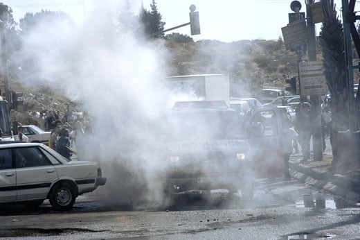
Posted by Ramy Nabil Abdeljabbar - Occupation forces target a PRCS ambulance, firing tear gas through the rear window, which exploded inside.
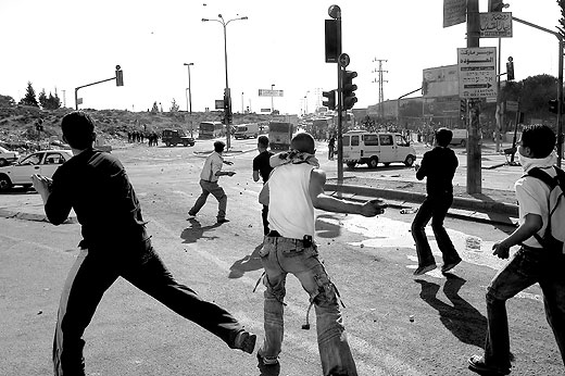
Posted by Ramy Nabil Abdeljabbar - Young Palestinian men throw stones at Occupation forces.
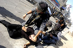
Posted by Ramy Nabil Abdeljabbar - Occupation forces run into the streets of Ar Ram while plain clothes troops, who had infiltrated the demonstration, tackle and arrest protestors.
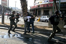
Posted by Ramy Nabil Abdeljabbar - Occupation forces arresting Palestinian demonstrators on the streets of Ar Ram.
Posted by Ramy Nabil Abdeljabbar - A drum band prepares to lead the demonstration from the centre of Ar-Ram to the Dahiat al Barid checkpoint.

Posted by Ramy Nabil Abdeljabbar - Organizers ready the assembled demonstrators to begin the march.

Posted by Ramy Nabil Abdeljabbar - Demonstrators carry huge banners against the Apartheid Wall.

Posted by Ramy Nabil Abdeljabbar - Demonstrators en route to Dahiat Al Barid checkpoint, walking along to main road between Ramallah and Jerusalem.
Posted by Ramy Nabil Abdeljabbar - After the demonstration at the Dahiat Al Barid checkpoint, the protestors travelled to Qalandiya to learn about the Wall construction throughout the area.

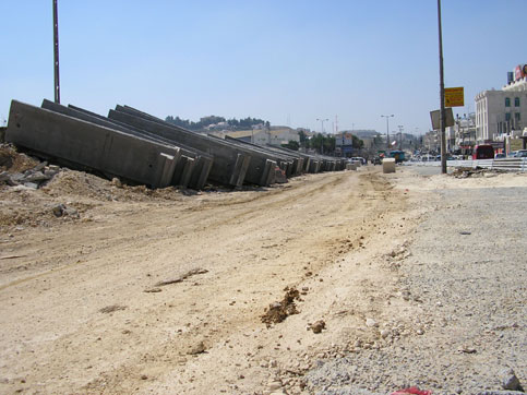
Posted by Ramy Nabil Abdeljabbar - Occupation forces unloading segments of the Wall along the main road through Beit Hanina

Posted by Ramy Nabil Abdeljabbar - Occupation forces unloading segments of the Wall along the main road through Beit Hanina

Posted by Ramy Nabil Abdeljabbar - Occupation forces unloading segments of the Wall along the main road through Beit Hanina. Every few days the troops have beenr eturning to place more blocks along the road.

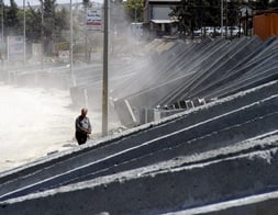
Posted by Ramy Nabil Abdeljabbar - These segments of the Apartheid Wall have been relocated from sections of Abu Dis, where the 8m Wall is completed. Grafitti from previous demonstrations can be seen on many of the blocks.

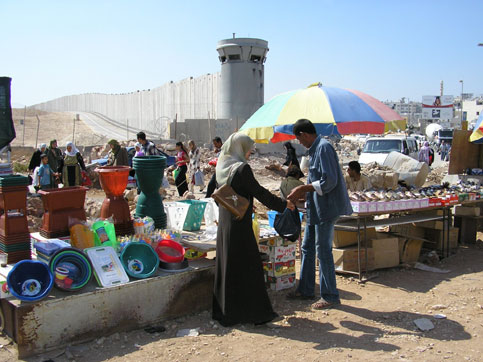
Posted by Ramy Nabil Abdeljabbar - A fruit seller who will eventually be on the West Bank side of the Wall.

Posted by Ramy Nabil Abdeljabbar - An attempt to 'beautify' a section of the Wall from a previous location.

Posted by Ramy Nabil Abdeljabbar - Mud, grafitti, and attempts to clean the blocks are clear evidence that these sections of the Apartheid Wall have been relocated from completed sections of the Wall.

Posted by Ramy Nabil Abdeljabbar - A taxi passes a section of the Apartheid Wall. Grafitti from a past demonstration reads in english

Posted by Ramy Nabil Abdeljabbar - Photo One: Construction of the Wall East of Al Ram. The Segregation Wall cuts close to Al Ram on its Eastern edge, appropriating large areas to the illegal Israeli settlement of Neve Ya'acov, which sits on the opposite hill, left of the Wall.

Posted by Ramy Nabil Abdeljabbar - Photo Two: Construction of the Wall East of Al Ram

Posted by Ramy Nabil Abdeljabbar 1 - Photo Three: Qawasmeh Home, threatened with Demolition

Posted by Ramy Nabil Abdeljabbar - Photo Four: Appropriated Stone Quarry with Neve Ya'acov behind

Posted by Ramy Nabil Abdeljabbar - By-Pass Road along Al Ram's Northern Edge

Posted by Ramy Nabil Abdeljabbar - Roadblock Between Al Ram and Jaba'

Posted by Ramy Nabil Abdeljabbar 1 - Israeli Construction Crews Close Gaps in the Wall Between Al Ram (behind) and Beir Nabala

Posted by Ramy Nabil Abdeljabbar - Everyone in ar Ram and Ad Dahiet has worked together to give the Occupation a clear message: United we stand against your ghetto walls.

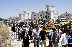
Posted by Ramy Nabil Abdeljabbar - A thousand people came together to protest the ghettoization of ar Ram and the Judaization of the Palestinian capital Jerusalem.

Posted by Ramy Nabil Abdeljabbar - Youth defend ar Ram and the protestors from the attacks of the Occupation.

Posted by Ramy Nabil Abdeljabbar - Nothing will silence the determination of the Palestinian call for liberation.

Posted by Ramy Nabil Abdeljabbar - The Apartheid Wall in Dahiet al Barid and ar Ram cuts through the main road. One side of the road has been completely dismantled.

Posted by Ramy Nabil Abdeljabbar - The Wall in the eastern side of Al-Ram and Dahiat Al-Bared, being built to annex all the land for the future expansion of Neve Ya?acov and Pisgat Ze?ev settlements.

Posted by Ramy Nabil Abdeljabbar - Occupation forces gather in Qalandiya checkpoint, just before the demonstrators arrived from Ar-Ram.

Posted by Ramy Nabil Abdeljabbar - A Hardware store along the Jerusalem - Ramallah road which will be isolated with all the rest of its neighbouring shops in the Ar Ram ghetto.

Posted by Ramy Nabil Abdeljabbar - The tent in Ar Ram where the hunger strike is taking place.

Posted by Ramy Nabil Abdeljabbar - Inside the tent interviews, meetings take place around the devestating implications of the Apartheid Wall on Palestine. Local & national politicians, solidarity groups, and the general public are also present to show thier support.

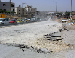
Posted by Ramy Nabil Abdeljabbar - After the work was completed the side roads are completely closed with no cars being able to access the roads.

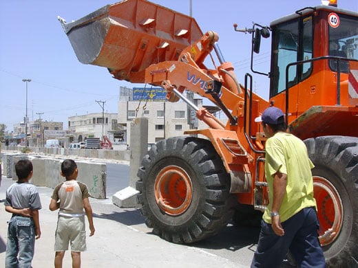
Posted by Ramy Nabil Abdeljabbar - An Occupation bulldozer moving blocks from the centre of the road to the block the side roads.

Posted by Ramy Nabil Abdeljabbar - Occupation work crews moving the blocks into place.

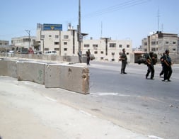
Posted by Ramy Nabil Abdeljabbar - Ar-Ram checkpoint. Two MW members observing at Ar-Ram checkpoint.

Posted by Ramy Nabil Abdeljabbar - Ar-Ram checkpoint. Palestinian detainees, guarded by a soldier at Ar-Ram checkpoint.

Posted by Ramy Nabil Abdeljabbar - Ar-Ram checkpoint. Palestinian neighborhood adjacent to Ar-Ram checkpoint.

Posted by Ramy Nabil Abdeljabbar - Ar-Ram checkpoint. Palestinian children walking by the graffitied wall at Ar-Ram Checkpoint.

Posted by Ramy Nabil Abdeljabbar - The wall at Ar-Ram.

Posted by Ramy Nabil Abdeljabbar - An old Palestinian woman trying her best to convince the soldier to let her cross the checkpoint.

Posted by Ramy Nabil Abdeljabbar - Soldiers block Palestinians from crossing to Jerusalem during the time of Ramadan.

Posted by Ramy Nabil Abdeljabbar - Palestinians trying to convince the soldier to let them cross to Jerusalem to participate in Ramadan prayer.

Posted by Ramy Nabil Abdeljabbar - Soldiers, including horsemen, block Palestinians to cross to Jerusalem during the time of Ramadan.

Posted by Ramy Nabil Abdeljabbar - Massive construction at the checkpoint.

Posted by Ramy Nabil Abdeljabbar - The lower part of the wall erected at Abu Dis.

Posted by Ramy Nabil Abdeljabbar - Soldiers, including horsemen block Palestinians from crossing to Jerusalem during the time of Ramadan.

Posted by Ramy Nabil Abdeljabbar - Part of the wall constructions in Ar-Ram town.

Posted by Ramy Nabil Abdeljabbar - Part of the wall constructions in Ar-Ram town.

Posted by RamRum - Father tries to help his son to cross the Ar-Ram CP in order get to school.

Posted by RamRum 1 - A Palestinian car driving by the Segregation Wall in Ar-Ram town.

Posted by Ramy Nabil Abdeljabbar - The Segregation Wall in Ar-Ram town, separating it from two parts.

Posted by Ramy Nabil Abdeljabbar - The Wall runs inside Ar-Ram town, east of Jerusalem.

Posted by Ramy Nabil Abdeljabbar - Protestors in Ar-Ram with banners.

Posted by Ramy Nabil Abdeljabbar - Demonstration in Ar-Ram against the wall.

Posted by Ramy Nabil Abdeljabbar - Demonstration in Ar-Ram get attacked by Israeli soldiers.

Posted by Ramy Nabil Abdeljabbar - Israeli soldiers in Ar-Ram steal banners from the demonstrators.

Posted by Ramy Nabil Abdeljabbar - An old Palestinian woman approaching the CP.

Posted by Ramy Nabil Abdeljabbar - Nuns cross into Jerusalem through the A-Ram checkpoint March 30, 2008. Israel announced plans on Sunday to ease some restrictions on Palestinians in the occupied West Bank, responding to calls by visiting U.S. Secretary of State Condoleezza Rice to take steps to bolster peace talks.

Posted by Ramy Nabil Abdeljabbar - The Apartheid Wall in Ar Ram Reinforces Zionist Apartheid.

Posted by Ramy Nabil Abdeljabbar - Main Street at Ar-Ram.

Posted by Ramy Nabil Abdeljabbar - Ar-Ram checkpoint.

Posted by Ramy Nabil Abdeljabbar - The 'security fence' between Qalandya refugee camp and the arab neighborhood of East Jerusalem called Ar-Ram.

Posted by Ramy Nabil Abdeljabbar - Scene at the Ar-Ram checkpont.

Posted by Ramy Nabil Abdeljabbar - Palestinians walk next to the Israeli separation wall in the west bank town of Al Ram.

Posted by Ramy Nabil Abdeljabbar - Muro in Ar-Ram.

Posted by Ramy Nabil Abdeljabbar - Checkpoint at Ar-Ram.

Posted by Ramy Nabil Abdeljabbar - Separation Wall in Ar Ram.

Posted by Ramy Nabil Abdeljabbar - Palestinian and Israeli participants in Combatants For Peace at the event in al-Ram.

Posted by Ramy Nabil Abdeljabbar - Palestinians climb the controversial Israeli separation wall as they try to bypass the Al-Ram checkpoint, on the edge of Jerusalem, after Israeli soldiers prevented them from entering Jerusalem to pray at the Al-Aqsa mosque on the last Friday of the holy month of Ramadan, 20 October 2006.
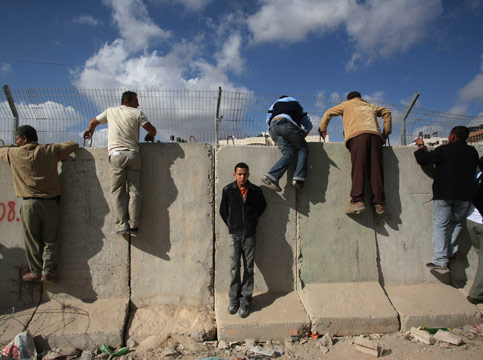
Posted by Ramy Nabil Abdeljabbar - Palestinians climb the controversial Israeli separation wall as they try to bypass the Al-Ram checkpoint, on the edge of Jerusalem, after Israeli soldiers prevented them from entering Jerusalem to pray at the Al-Aqsa mosque on the last Friday of the holy month of Ramadan, 20 October 2006.

Posted by Ramy Nabil Abdeljabbar - Nuns working at the Rosary Sisters' School in the Jerusalem neighborhood of Al-Ram.

Posted by Ramy Nabil Abdeljabbar 1 - A Palestinian climbing a makeshift ladder to cross Israel's eight-meter-high concrete barrier in the Palestinian village of al-Ram on the outskirts of Jerusalem; Jun 4 2007.

Posted by Ramy Nabil Abdeljabbar - A Palestinian worker climbs over a section of Israel's separation barrier from the Palestinian village of Al-Ram towards Jerusalem, Sunday, Feb. 18, 2007.

Posted by Ramy Nabil Abdeljabbar - Palestinians cross a section of Israel's separation barrier from the Palestinian village of Al-Ram towards Jerusalem, Sunday, Feb. 18, 2007.

Posted by Ramy Nabil Abdeljabbar - Palestinians cross a section of Israel's separation barrier from the Palestinian village of Al-Ram towards Jerusalem, Sunday, Feb. 18, 2007.

Posted by Ramy Nabil Abdeljabbar - Apartheid Wall in Ar-Ram.

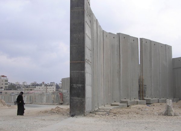
Posted by Ramy Nabil Abdeljabbar - A partial view of the Palestinian village of Al-Ram on the outskirts of Jerusalem.

Posted by Ramy Nabil Abdeljabbar - Protest against the Apatheid Wall in Ar-Ram.

Posted by Ramy Nabil Abdeljabbar - A Palestinian school boy walks through a military Israeli checkpoint in the West Bank village of al-Ram, on the northern outskirts of Jerusalem, in March 2008. The Israeli army dismantled on Thursday 10 roadblocks in the West Bank, as part of a pledge to US Secretary of State Condoleezza Rice to remove 50 in the occupied region, an army spokeswoman said.

Posted by Ramy Nabil Abdeljabbar - The Apartheid Wall blocks lots of gaps in Ar-Ram.

Posted by Ramy Nabil Abdeljabbar - Palestinian men, women and children waiting in line to cross Qalandia checkpoint in Ar-Ram to Ramallah.

Posted by Ramy Nabil Abdeljabbar - Palestinian men, women and children waiting in line before crossing Qalandia checkpoint from Ramallah to ar-Ram.

Posted by Ramy Nabil Abdeljabbar - Traditional Palestinian red dress in Ar-Ram.

Posted by RamRum - Traditional Palestinian Blue Formal Dress in Ar-Ram.

Posted by Ramy Nabil Abdeljabbar - Qalandia checkpoint in Ar-Ram.

Posted by Ramy Nabil Abdeljabbar - Palestinians boys walk along the controversial Israeli barrier in al-Ram, on the edge of Jerusalem June 12, 2008.

Posted by RamRum - The Wall in Ar-Ram.
Posted by RamRum - Decorated stall and wall at Ar-Ram checkpoint.

Posted by RamRum - Graffiti on the wall at Ar-Ram.

Posted by RamRum - An Ar-Ram checkpoint with no Palestinians.

Posted by RamRum - Graffiti on the Palestinian side of Ar-Ram wall.

Posted by RamRum - Graffiti on the wall at Ar-Ram.

Posted by RamRum - Graffiti on the Palestinian side of Ar-Ram wall.

Posted by RamRum - Graffiti on the Palestinian side of Ar-Ram wall.

Posted by RamRum - Graffiti on the wall at Ar-Ram.

Posted by RamRum - A detail of the wall in Ar-Ram.

Posted by RamRum - Palestinian children walking along The Wall at Ar-Ram.

Posted by RamRum - The separation wall on the Palestinian side.

Posted by RamRum - At the checkpoint.

Posted by RamRum - .School girls waiting to cross the CP.

Posted by RamRum - Crossing the CP.

Posted by RamRum - Detainees at the CP.

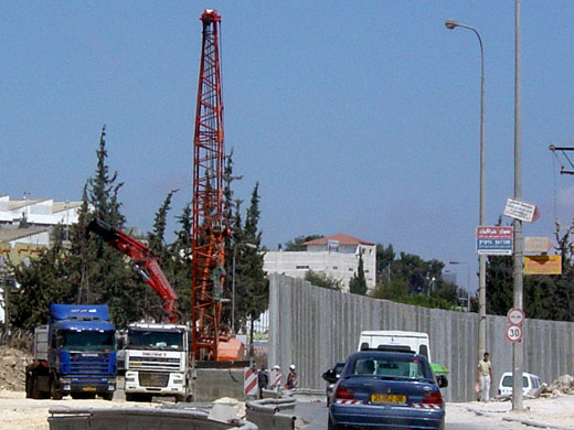
Posted by RamRum - Part of the Israeli intensive development program in Ar-Ram town preparing for the Segregation Wall.

Posted by RamRum - Ar-Ram Bir Nibala road junction.

Posted by RamRum - The wall constructions in Ar-Ram town divide the road into two parts.

Posted by RamRum - Wall blocks placed on Ar-Ram-Bir Nibala road junction.

Posted by RamRum - A look at the wall blocks in Ar-Ram town preparing for the wall constructions in the area.

Posted by RamRum - Detainees at the checkpoint.

Posted by RamRum - Al-Ram Gate

Posted by Sameer Abdeljabbar - Al-Ram

Posted by Sameer Abdeljabbar - Al-Ram

Posted by Sameer Abdeljabbar - Al-Ram border with Ramallah

Posted by Sameer Abdeljabbar - The Wall, al-Ram, Jerusalem. Some of the graffiti on the wall is quite banal. Not all of it is "political."

Posted by Sameer Abdeljabbar - Al-Ram - Dahiyet al-Bareed

Posted by Sameer Abdeljabbar - Israeli Apartheid Wall in Al-Ram

Posted by RamRum - Al-Ram

Posted by RamRum - Al-Ram in the north near Ramallah

Posted by RamRum - Al-Ram in the north near Ramallah

Posted by RamRum - Palestinian soccer game in Al-Ram

Posted by RamRum - Al-Ram

Posted by RamRum - Wall in Al-Ram

Posted by RamRum - Al-Ram Wall, East Jerusalem

Posted by RamRum - Al-Ram Wall, East Jerusalem

Posted by RamRum - Al-Ram Wall, East Jerusalem

Posted by RamRum - Wall protest in Al-Ram

Posted by RamRum - Palestinian girls playing in Al-Ram

Posted by RamRum - Al-Ram

Posted by RamRum - An Israeli army jeep stands by as Israeli workers add barbed wire to the top of the wall in the West Bank village of Al-Ram the lies between Jerusalem and Ramallah city on August 6, 2008. Israel says the barrier is needed for its security, while Palestinians view it as a land grab that undermines their future state. The International Court of Justice issued a non-binding resolution in 2004 calling for parts of the barrier inside the West Bank to be demolished and for a halt to construction there, a call that has so far been ignored by Israel.

Posted by RamRum - Muhammed Eid (R) from Palestine and Sadec Zamar (L) from Chechnya fight for the ball during a friendly soccer match in al-Ram in the West Bank, on the outskirts of Jerusalem June 6, 2009.

Posted by RamRum - Members of the Palestinian national soccer team run on the pitch before their soccer friendly match against Jordan in al-Ram October 26, 2008. The Palestinian national team plays its first match on home soil on Sunday when they host Jordan in an international friendly at a new stadium in the West Bank on the outskirts of Jerusalem, the Palestinian FA chairman said.

Posted by RamRum - Palestinian Fahed Atal (L) and Jordan's Amar Aleqh (R) vie for the ball during their friendly football match at the newly established stadium in the West Bank town of Al-Ram, on the outskirts of Jerusalem on October 26, 2008. The new stadium trembled as thousands of Palestinians cheered their national football team in its first-ever home match near Jerusalem today. The Palestinians still long for their own state and an end to the decades-old Israeli occupation, but football fans were nevertheless able to share a rare moment of national joy in the cool autumn night.

Posted by RamRum - Palestinian youths burn tires and throw stones at Israeli forces as a protest against Israel?s assault on the Gaza Strip on March 3, 2008 in the West Bank village of al-Ram. Israel vowed today to keep hitting Gaza even as troops pulled out of the Hamas-run territory after clashes that killed more than 110 Palestinians and dealt a major blow to Middle East peacemaking.

Posted by RamRum - Palestinian man walks through a flooded water pipe underneath a section of Israel's separation barrier between the West Bank town of al-Ram and Jerusalem on 16 February 2008. In 2004, the International Court of Justice issued a non-binding ruling that parts of Israel's 650-kilometre (410-mile) separation barrier criss-crossing the West Bank are illegal and should be torn down.

Posted by RamRum - Fatah supporters attend a rally marking Independence Day in the West Bank town of Al-Ram, on the outskirts of Jerusalem, on November 15, 2008. Celebrations were held by pro-Fatah Palestinians in several West Bank towns today to mark the anniversary of the 1988 symbolic declaration of independence by the late Palestinian leader Yasser Arafat.

Posted by RamRum - Palestinian fans watch a friendly soccer match against Chechnya in al-Ram in the West Bank on the outskirts of Jerusalem June 6, 2009.

Posted by RamRum - FIFA President Sepp Blatter (C) and Palestinian FA chairman Jibril Rajoub (R) acknowledge fans before a soccer friendly match between the Palestinian and Jordanian national teams in al-Ram October 26, 2008. The Palestinian national team played its first match on home soil on Sunday when they hosted Jordan in an international friendly at a new stadium in the West Bank on the outskirts of Jerusalem.

Posted by RamRum - Palestinian fans watch a friendly soccer match against Chechnya in al-Ram in the West Bank on the outskirts of Jerusalem June 6, 2009.

Posted by RamRum - The serpentine path of a concrete section of the Israeli security barrier divides the Palestinian town of Al Ram, left, and the Israeli town of Pisgat Ze'ev, right, north of Jerusalem.

Posted by RamRum - Ar-Ram checkpoint in East Jerusalem

Posted by RamRum - A Palestinian passes by towards Al-Ram checkpoint in northern Jerusalem.

Posted by RamRum 1 - Demonstration in Al-Ram

Posted by RamRum - Demonstration in Al-Ram

Posted by RamRum - The wall going through Ar-Ram

Posted by RamRum - Al-Ram

Posted by RamRum 1 - Al-Ram

Posted by RamRum - Al-Ram

Posted by RamRum - Al-Ram

Posted by RamRum - Al-Ram

Posted by RamRum 1 - Al-Ram

Posted by RamRum 1 - Al-Ram

Posted by RamRum - Qatamon house rented by British family 1939 to 1944

Posted by qatamonica - Al-Ram in the background

Posted by Ramy Abdeljabbar - صوره قديمه لمدرسه قريه الرام

Posted by abu raya - صوره قديمه من قريه الرام قبل النكبه

Posted by abu raya - مدرسة الرام في 12.5.1911

- بلدة الرام شمال القدس في عام 1900م

Want to browse more? 80,000 pictures were grouped in these gallaries:
| Display Name | Clan/Hamolah | Country of Residence |
| Mashhour Amawi | - | - |
| ابو مجد | مسلماني | القدس, الرام |
| Ramy Nabil Abdeljabbar | Abdeljabbar | New Jersey, United States of America |
- Seperation Wall in Al-Ram, Palestine Duration: 30 sec
- Demonstration against the wall in al-Ram Duration: 2 min 30 sec
No links have been shared yet, be free to the first to share the first link.
 Fake Valor: Why Did Zionist Jews Hoist Nazis Flag on Their Ships in the 1930s?
What is new?
-
Facts About Oct. 7th Gaza Raid
-
Remined Us Please: Who Did Rape Whom? Was it Palestinians who raped Israelis? Or, was the other way around? You'll be the judge
-
When Prof. Edward Said was invited to debate Bibi Netanyahu in the 1980s, watch what happened!
-
Ezra Klein of the NY Times on the "Jewish Race".
-
Abusing Blood Libel!
-
How and why Israeli Jewry has become the most hated cult?
-
Did Israeli Soldiers Activate The Hannibal Direective On Oct. 7th? You Be The Judge
-
Zionist FAQ: Isn't it true that Palestinians don't want peace? Palestinians never accepted the two-state solution
- Facts about Haavara (Transfer) Agreement between Ben-Gurion & Hitler
-
Haavara FAQs: Why Did Zionist Jews Hoist Nazis' Flags on Their Ships in the 1930s?
- Haavara FAQs: When Chaim Weizmann met FDR in mid-1943, why was he silent about rescuing European Jewry?
-
Dear ChatGPT: How did Palestinians resist Napoleon's invasion of their country in 1799?
-
Dear ChatGPT: Gaza had a vibrant Jewish community in the mid-17th century. What happened to them?
-
Dear ChatGPT: Why did the Jewish Agency suppress news of the Holocaust during WWII?
-
Video Playlist: Jews share their DNA tests to end the conflict for good.
-
A Tale of Two Conflicts: Examining the Definition of Genocide
-
Prof. Abraham Polak And The Suppressed History of the Khazars and European Jewry
-
How Ronald Reagan would have framed the genocide in Gaza if he were still alive?
-
Haavara FAQs: Let us do the math: how many German Jews did The Haavara Agreement save?
-
Zionist FAQs: The Hebron Massacre of 1929, "clearly proves" that Palestinians are antisemitic, how could you deny it?
-
Zionist FAQs: Why Anti-Zionist Is Not Antisemitism?
-
Zionist FAQs: Isn't it true that the KGB created Palestinian Nationalism in the early 1960s?
- Zionist FAQs: Muslims are killing Muslims all the time; why are Israeli Jews being singled out in the media?
- Zionist FAQs: How is Israel an apartheid state when 20% of its citizens are Arabs who enjoy full rights?
-
Haavara FAQs: Why Did Dorothy Thompson Flip From A Zionist Advocate to A Silenced Dissenter?
-
Haavara FAQs: Analysis of Herzl's Uganda Scheme and how it could have saved millions of Jews.
-
Haavara FAQs: Why did Hayim Greenberg describe American Jewry as "morally bankrupt" in early 1943?
-
Haavara FAQs: What if the Evian Conference was a resounding success? What would have been the impact of saving European Jewry on Zionism?
- Haavara FAQs: What if the six million were saved, how that would have impacted the Zionist project?
-
Haavara FAQs: How did Zionist leaders react when Europe's Jews lingered in the DP camps after WWII ended?
-
Why does the American Jewish community repeat lies that David Ben-Gurion had debunked before he died?
-
Who has the power to rename the Tatar/Khazar Gene Marker to Jewish IV?
-
Zionist FAQs: Why won't Egypt, Syria, and Jordan take their people back? Jews are indigenous to Palestine, and Arabs immigrated after Jews developed the country. Arabs should leave.
-
Haavara FAQs: Did Hitler and the Nazis conflate between Judaism and Zionist? If that wasn't case, then why?
-
Haavara FAQs: Winston Churchill and antisemitism, a collection of articles written Churchill.
-
Haavara FAQs: Broken by country, how many Jews survived vs. killed during the Holocaust?
-
Haavara FAQs: Why did European Jews vote with their feet and to immigrated to the Americas, not Palestine, after WWII?
-
Watch this American Jewish Girl describing Israeli Jews' cognitive dissonance like no other in under two minutes
-
Haavara FAQs: When the Nazis went out of their way to hide the Holocaust, Israeli Jews did the exact opposite by broadcasting their genocide of Gazans. But why?
-
Haavara FAQs: How Zionist Jews went out of their to show their appreciation to Nazism and Fascism?
- Haavara FAQs: Why Zionist leaders were against bombing the death camps & the Railroads leading to them?
-
Haavara FAQs: Hitler's message to the British and American people: If Jews are such noble citizens and you care about them, how come you're not letting them in? I will gladly ship them to you at my expense, even on luxury liners!
-
A shortlist of Zionist and Israeli false flag operations in the name Jews.
-
The Most Moral Army
- The Land of Kapos (Israel): Where the brave are boycotted and Kapos walk free.
- Why did early Zionists often named their communal enterprises "colonial"?
- Zionist Relations with Nazi Germany by Faris Glubb
-
Two NY Times advertisements by Zionists in the early 1943 that exposes Zionists' treason at the height of the calamity
- Facts Not Lies about the Palestinian-Israeli Conflict.
- Site's pictures have been categorized
- Campgain Against Lice
- A Survey of Palestine, the official source about Palestine before Nakba produced by the British Mandate; over 1200 pages.
- Satellite View & Google Earth: Over 6,000 placemarks identifying all destroyed towns, W. Bank & Gaza Strip Towns, & refugee camps.
- PalestineRemembered.com and its Nakba Oral History Project were featured on al-Jazeera Satellite TV.
- Nakba Oral History Video Podcast:
 Over 700 Oral History interviews (including 3,500+ hours of recording) can be viewed online.
 - Palestine Village Statistics Project
- Gaza Jail Break
- النسخة العربية للموقع الان متوفرة
- Videos: Documenting the destroyed villages in video: Tracing all that remains since Nakba.
- Videos: Responding to Zionist Propaganda
- Interview: The ethnic cleansing of Palestine: George Galloway interviews Israeli Historian Ilan Pappe.
- For Palestinians, memory matters. It provides a blueprint for their future By George Bisharat.
- Zionist FAQ now available in Hebrew שאלות שציונים שואלים, עכשיו בעברית
- Video: The Stephen Walt and John Mearsheimer report on the influence of the Israel Lobby on U.S. Foreign Policy
- The Palestinian-Israeli conflict for beginners
