| PalestineRemembered | About Us | Oral History | العربية | |
| Pictures | Zionist FAQs | Haavara | Maps | |
| Search |
| Camps |
| Districts |
| Acre |
| Baysan |
| Beersheba |
| Bethlehem |
| Gaza |
| Haifa |
| Hebron |
| Jaffa |
| Jericho |
| Jerusalem |
| Jinin |
| Nablus |
| Nazareth |
| Ramallah |
| al-Ramla |
| Safad |
| Tiberias |
| Tulkarm |
| Donate |
| Contact |
| Profile |
| Videos |
Welcome To 'Artuf - عرتوف (ערתוף)
|
District of Jerusalem
Ethnically cleansed days ago |
العربية Google Earth |
 |
Gallery (44) |
- Statistics & Facts
-
Before & After

- Satellite View
- Articles 2
- Pictures 44
- Aerial Views 1
- Oral History 2
- Members 25
- All That Remains
- Wikipedia
- Videos 2
- Guest Book 10
- Links 1
| Statistic & Fact | Value | ||||||||||||||
| Occupation Date | July 18, 1948 | ||||||||||||||
| Distance From District | 21.5 (km) West of Jerusalem | ||||||||||||||
| Elevation | 250 (meters) | ||||||||||||||
| Before & After Nakba, Click Map For Details |
|||||||||||||||

|
|||||||||||||||
| Pre-Nakba Aerial View |
|||||||||||||||

|
|||||||||||||||
| Map Location | See location #23 on the map View from satellite |
||||||||||||||
| Military Operation | Second phase of Operation Dani | ||||||||||||||
| Attacking Units | The Fourth Battalion of the Har'el Brigade | ||||||||||||||
| Defenders | Egyptian Muslim Brotherhoods, some Arab Liberation Army volunteers, and some local Palestinian militia. | ||||||||||||||
| Exodus Cause | Military assault by Zionist troops | ||||||||||||||
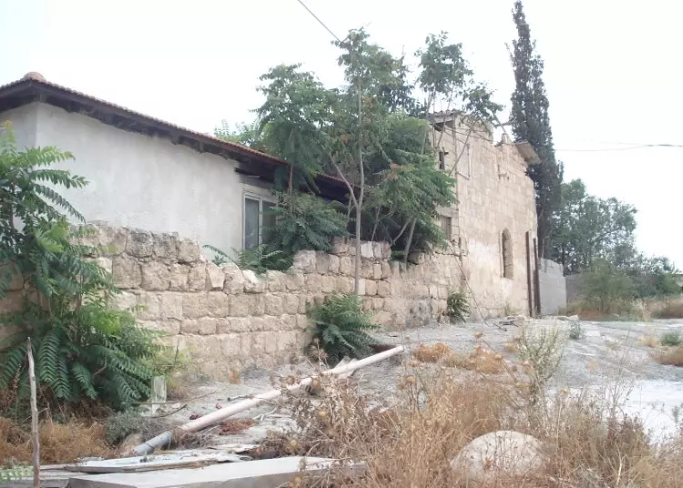
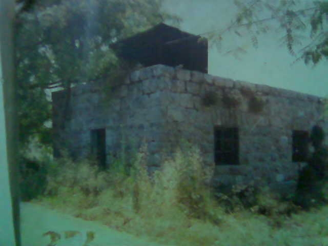
| Village Temains | Artuf was mostly destroyed and defaced with the exception of two village houses and the village cemetery. | ||||||||||||||
| Ethnically Cleansing | 'Artuf inhabitants were completely ethnically cleansed. | ||||||||||||||
| Pre-Nakba Land Ownership |
**Town Lands' Demarcation Maps |
||||||||||||||
| Land Usage As of 1945 |
|
||||||||||||||
| Population |
|
||||||||||||||
| Number of Houses |
|
||||||||||||||
| Near By Towns |
|||||||||||||||
|
|||||||||||||||
| Schools | One elementary school | ||||||||||||||
| Places of Warship | 'Artuf had a mosque known by al-'Umari Mosque. | ||||||||||||||
| Shrines / Maqams | And it also had a maqam for a local sage known as al-Shaykh 'Ali al-Ghimadi. | ||||||||||||||
| Archeological Sites | The village contains Khirbat Marmita and Khirbat al-Burj. | ||||||||||||||
| Exculsive Jewish Colonies That Usurped Village Lands |
Hartuv, Nacham, and possibly Beit Shemesh too. | ||||||||||||||
| Featured Video | |||||||||||||||
Village Before NakbaThe village stood on a moderately high plateau, surrounded by plains on the south, east, and west. It was on a secondary road that linked it to a highway leading to Jerusalem. In 1596, 'Artuf was a village in the nahiya of Ramla (liwa' of Gaza) with a population of 110. It paid taxes on a number of crops, including wheat, barley, and fruit, as well as on other types of produce and property, such as goats, beehives, and vineyards. In the late nineteenth century, 'Artuf was a small village built on a low hill overlooking a Valley. The villagers obtained their water from a pool in the valley. Most houses were built of stone and mud; a few were built of stone and cement and had domed roofs. The residents, who were Muslims, worshiped in a mosque called the al-'Umari Mosque, perhaps in reference to 'Umar ibn al-Khattab, the second Muslim caliph. The tomb of a local Muslim sage named Shaykh 'Ali al-Ghimadi stood on the outskirts of the village.During the Mandate, the authorities established a fortified police station about 1 km west of 'Artuf and a train station just beyond that. In addition, 'Artuf had an elementary school. There was also a small Zionist settlement, Hartuv, southwest of the village. Hartuv was initially founded in 1883 by the London Society for the Promotion of Christianity Amongst the Jews. It failed, however, in 1886 because the Jewish settlers there resisted the English efforts to convert them to Christianity and left the settlement. It was revived in 1895 by Zionist settlers from Bulgaria who were citizens of the Ottoman empire and who spoke Turkish as well as Bulgarian and Ladino. As Ottoman citizens they had permission to settle near 'Artuf, had deeds to the land purchased for them by Zionist organizations, and gradually established peaceful relations with their Palestinian neighbors. Although the villagers of 'Artuf worried that the settlers would encroach upon their own land, they generally dealt with the settlers as neighbors. Unlike most other Zionist settlers, the inhabitants of Hartuv were willing to lease parts of their land to Arab cultivators, some of whom lived in 'Artuf. The settlement was not prosperous, however; in 1904 it had only 75 inhabitants. This was partly due to the inadequate support it received from mainstream Zionist organizations, which objected to the settlement's 'liberal' policies toward the Arabs. Many Zionists were opposed to the employment of Arab workers on Zionist land, and most certainly did not lease Zionist land to non-Jews. In 1929 Hartuv was destroyed during fighting between Zionists and Palestinians who came from other parts of the country. Although its Sephardic inhabitants returned soon after to rebuild it, the settlement did not expand. Its population was only 100 in 1948. Construction of the Zionist-sponsored 'Shimshon' cement factory was begun near 'Artuf in 1948, but it is not likely that any of the villagers found work there because of the Jewish National Fund's policy of excluding Arab labor from all Jewish enterprises. About half of the village population worked in agriculture, while the rest worked in the nearby Bab al-Wad railway station. Their agricultural lands extended west of the village, where fruit trees and almond trees were planted. In 1944/45 a total of 279 dunums was allotted to cereals; 61 dunums were irrigated or used for orchards, of which 20 dunums were planted with olive trees. In addition to the village itself, which had been constructed over an earlier settlement, there were two archaeological sites nearby: Khirbat Marmita (151130), about 1 km east of the village, and al-Burj (149129), on the site of Hartuv to the southwest. Excavation of Khirbat al-Burj has been carried out by the Hebrew University since 1985; it contains artifacts dating to the late fourth millenium B.C. and the Byzantine period. Village Occupation and Ethnic Cleaning'Artuf was one of three villages that had been punished by the British in late March 1948. After an Arab attack on the adjacent Jewish settlement of Hartuv, 600 British troops moved into 'Artuf, Ishwa', and Bayt Mahsir on 23 March. The New York Times correspondent reported that 'almost all the villagers' had been evacuated before the troops occupied the villages, but this evacuation was only temporary; the villagers returned shortly afterwards.It was not until mid-July that 'Artuf (and a number of other villages in the Jerusalem area) was actually depopulated. It was occupied during the second phase of Operation Dani (see Abu al-Fadl, Ramla sub-disctrict) by the Fourth Battalion of the Har'el Brigade. According to the History of the War of Independence and Israeli historian Benny Morris, this occurred during the night of 17−18 July 1948. The offensive is described by Morris as follows: 'Much of the population of these villages ... had left the area previously. Most of the remaining population fled with the approach of the Har'el columns and with the start of mortar barrages. The handful of people who remained at each site when the Israelis entered were expelled.' The Second Platoon of B Company (of the Fourth Battalion), armed with mortars and machine guns, first pushed out the inhabitants of nearby Ishwa' and 'Islin; then they moved toward 'Artuf. Aiming their mortars at the police station west of 'Artuf, they lobbed explosives at both the station and the village. This night-time bombardment convinced the villagers to flee. Most of them walked three miles up the slopes toward the village of Dayr al-Hawa, to the southeast. The first Israeli troops to enter the village, on the day after its depopulation, were members of a platoon commanded by Rafael Eytan. Zionists Colonies on Village LandsZionists had revived the settlement of Hartuv in 1895 (later known as Kefar 'Avodat Hartuv) on village lands, but it was abandoned several times. The settlement of Nacham (150130) was established in 1950 on the ruins of the village of 'Artuf and the Zionist settlement of Hartuv. Beyt Shemesh (149129) was established near the site in 1950 on land that had belonged to the village of Dayr Aban.Village TodayOne stone house, located outside the Jewish settlement of Nacham, has been expanded, and is now inhabited by a Jewish family. In the middle of the Jewish settlement is a small stone house that is used as a warehouse; it stands by the site of the former mosque. On the western slopes of the site is a circular structure with no roof that was formerly used as a lime kiln (kabbara). Limestone was heated in the kabbara until it was reduced to powder, and this powder, mixed with water, served as whitewash for walls. The village cemetery, to the west, has been levelled; only one or two graves remain on its eastern edge. Part of the British police headquarters is still standing. Elsewhere, the village site is covered with scattered stone rubble. Olive, fig, and cypress trees grow on the village site, especially in the west and north.SourceDr. Walid al-Khalidi, 1992: All That Remains. |
|||||||||||||||
| Related Maps | Town Lands' Demarcation Maps خرائط للقضاء توضح حدود القرى والاودية Town's map on MapQuest View from satellite Help us map this town at WikiMapia |
||||||||||||||
| Related Links | Wikipedia's Page Facebook Page Google Search Google For Images Google For Videos |
||||||||||||||
| More Information | في كتاب كي لا ننسى في كتاب بلادنا فلسطين المزيد من موقع هوية |
||||||||||||||
- مسجد قرية
Posted by بنت الشتات 3 - أحداث غضب في 1927 -اراق بيادر

Posted by ابو عمر 2 - صورة بمناسبة زواج السيد محمد خليل يوسف رحال(عرتوف)على السيده جميله خليل حسن جبيل(النعاني)1963

Posted by ابن عنابه - موسى محمد رحال

Posted by rahal 3 - قرية عرتوف 1948 - مشاركة صفافي

Posted by صفافي أصيل - قرية عرتوف 19.7.1948 - مشاركة صفافي

Posted by صفافي أصيل - داخل بيت في عرتوف 1948 - مشاركة صفافي

Posted by صفافي أصيل - قطار عرتوف - حماد رحال

Posted by عرتوف - صورة الشجر المعمر- المصور: احمد سلطان

- عرتوف

Posted by abu raya - بيوت عرتوف
Posted by abu raya - عرتوف

Posted by abu raya - جولة بين انقاض قرية عرتوف المهجره - برنامج جذور مقدسية

- جولة بين انقاض قرية عرتوف المهجره - برنامج جذور مقدسية #2

- جولة بين انقاض قرية عرتوف المهجره - برنامج جذور مقدسية #3

- جولة بين انقاض قرية عرتوف المهجره - برنامج جذور مقدسية #4

- جولة بين انقاض قرية عرتوف المهجره - برنامج جذور مقدسية #5

- جولة بين انقاض قرية عرتوف المهجره - برنامج جذور مقدسية #6

- جولة بين انقاض قرية عرتوف المهجره - برنامج جذور مقدسية #7

- جولة بين انقاض قرية عرتوف المهجره - برنامج جذور مقدسية #8

- جولة بين انقاض قرية عرتوف المهجره - برنامج جذور مقدسية #9

- جولة بين انقاض قرية عرتوف المهجره - برنامج جذور مقدسية #10

- جولة بين انقاض قرية عرتوف المهجره - برنامج جذور مقدسية #11

- جولة بين انقاض قرية عرتوف المهجره - برنامج جذور مقدسية #12

- جولة بين انقاض قرية عرتوف المهجره - برنامج جذور مقدسية #13

- Omari Mosque in 1996

- صورة نادرة من الجو لقرية عرتوف قضاء القدس عام 1947..
- The "civilized" who landed on us from Europe completely defaced our village. Those people expect "peace" from those whom they replaced!

- The "civilized" who landed on us from Europe completely defaced our village. Those people expect "peace" from those whom they replaced! #2

- The "civilized" who landed on us from Europe completely defaced our village. Those people expect "peace" from those whom they replaced! #3

- The "civilized" who landed on us from Europe completely defaced our village. Those people expect "peace" from those whom they replaced! #4

- The "civilized" who landed on us from Europe completely defaced our village. Those people expect "peace" from those whom they replaced! #5

- The "civilized" who landed on us from Europe completely defaced our village. Those people expect "peace" from those whom they replaced! #6

- The "civilized" who landed on us from Europe completely defaced our village. Those people expect "peace" from those whom they replaced! #7

- The "civilized" who landed on us from Europe completely defaced our village. Those people expect "peace" from those whom they replaced! #8

- The "civilized" who landed on us from Europe completely defaced our village. Those people expect "peace" from those whom they replaced! #9

- The "civilized" who landed on us from Europe completely defaced our village. Those people expect "peace" from those whom they replaced! #10

- The "civilized" who landed on us from Europe completely defaced our village. Those people expect "peace" from those whom they replaced! #11

- The "civilized" who landed on us from Europe completely defaced our village. Those people expect "peace" from those whom they replaced! #12

- The "civilized" who landed on us from Europe completely defaced our village. Those people expect "peace" from those whom they replaced! #13

- The "civilized" who landed on us from Europe completely defaced our village. Those people expect "peace" from those whom they replaced! #14

- The "civilized" who landed on us from Europe completely defaced our village. Those people expect "peace" from those whom they replaced! #15

- The "civilized" who landed on us from Europe completely defaced our village. Those people expect "peace" from those whom they replaced! #16

- الصورة من قرية دير الهوى وجبال عرتوف من قرى القدس المهجرة منذ النكبة

Want to browse more? 80,000 pictures were grouped in these gallaries:
| Display Name | Clan/Hamolah | Country of Residence |
| محمد خاطر | - | الزرقاء, الأردن |
| أحمد سلطان | - | |
| عرتوف | رحال | - |
| وليد رحال | رحال | عمان, الاردن |
| فلسطين رحال | رحال | - |
| احمد رحال | - | - |
| ala khater | - | NJ , USA |
| ابن عرتوف | - | - |
| Shahin | Shahin | Jordan, Jordan |
| محمد رسول سلطان | سلطان | الاردن |
| om abdallah | shahada | Jordan |
| rahal | رحال | amman, jordan |
| ابو حسين | رحال | عرتوف |
| رحال | رحال | - |
| محمد | - | - |
| يزن سلطان | سلطان | - |
| yossi ben-artzi | - | haifa, israel |
| بنت الشتات | شتات | عمان, الأردن |
| adel shihadah | shihadah | khurtom, sudan |
| Jamila Shihadah | Shihadah | - |
| Thabit Shihadah | - | VA, USA |
| abdullahrahhal | rahhal | ontario, canada |
| Ahmad Shihadah | - | - |
| Abir Shahin | - | Va, USA |
| maher shuhadeh | shuhadeh | bahrain |
- عرتوف المهجرة | جذور مقدسية 2020 Duration: 23 min 38 sec
- من مطل قرية دير الهوى... نشاهد قرية عرتوف - ديربان - صرعه - أشوع - خربة ما شاء الله - عسلين - دير فات - بيت جيز - شرق الرمل Duration: 5 min 50 sec
 Fake Valor: Why Did Zionist Jews Hoist Nazis Flag on Their Ships in the 1930s?
What is new?
-
Facts About Oct. 7th Gaza Raid
-
Remined Us Please: Who Did Rape Whom? Was it Palestinians who raped Israelis? Or, was the other way around? You'll be the judge
-
When Prof. Edward Said was invited to debate Bibi Netanyahu in the 1980s, watch what happened!
-
Ezra Klein of the NY Times on the "Jewish Race".
-
Abusing Blood Libel!
-
How and why Israeli Jewry has become the most hated cult?
-
Did Israeli Soldiers Activate The Hannibal Direective On Oct. 7th? You Be The Judge
-
Zionist FAQ: Isn't it true that Palestinians don't want peace? Palestinians never accepted the two-state solution
- Facts about Haavara (Transfer) Agreement between Ben-Gurion & Hitler
-
Haavara FAQs: Why Did Zionist Jews Hoist Nazis' Flags on Their Ships in the 1930s?
- Haavara FAQs: When Chaim Weizmann met FDR in mid-1943, why was he silent about rescuing European Jewry?
-
Dear ChatGPT: How did Palestinians resist Napoleon's invasion of their country in 1799?
-
Dear ChatGPT: Gaza had a vibrant Jewish community in the mid-17th century. What happened to them?
-
Dear ChatGPT: Why did the Jewish Agency suppress news of the Holocaust during WWII?
-
Video Playlist: Jews share their DNA tests to end the conflict for good.
-
A Tale of Two Conflicts: Examining the Definition of Genocide
-
Prof. Abraham Polak And The Suppressed History of the Khazars and European Jewry
-
How Ronald Reagan would have framed the genocide in Gaza if he were still alive?
-
Haavara FAQs: Let us do the math: how many German Jews did The Haavara Agreement save?
-
Zionist FAQs: The Hebron Massacre of 1929, "clearly proves" that Palestinians are antisemitic, how could you deny it?
-
Zionist FAQs: Why Anti-Zionist Is Not Antisemitism?
-
Zionist FAQs: Isn't it true that the KGB created Palestinian Nationalism in the early 1960s?
- Zionist FAQs: Muslims are killing Muslims all the time; why are Israeli Jews being singled out in the media?
- Zionist FAQs: How is Israel an apartheid state when 20% of its citizens are Arabs who enjoy full rights?
-
Haavara FAQs: Why Did Dorothy Thompson Flip From A Zionist Advocate to A Silenced Dissenter?
-
Haavara FAQs: Analysis of Herzl's Uganda Scheme and how it could have saved millions of Jews.
-
Haavara FAQs: Why did Hayim Greenberg describe American Jewry as "morally bankrupt" in early 1943?
-
Haavara FAQs: What if the Evian Conference was a resounding success? What would have been the impact of saving European Jewry on Zionism?
- Haavara FAQs: What if the six million were saved, how that would have impacted the Zionist project?
-
Haavara FAQs: How did Zionist leaders react when Europe's Jews lingered in the DP camps after WWII ended?
-
Why does the American Jewish community repeat lies that David Ben-Gurion had debunked before he died?
-
Who has the power to rename the Tatar/Khazar Gene Marker to Jewish IV?
-
Zionist FAQs: Why won't Egypt, Syria, and Jordan take their people back? Jews are indigenous to Palestine, and Arabs immigrated after Jews developed the country. Arabs should leave.
-
Haavara FAQs: Did Hitler and the Nazis conflate between Judaism and Zionist? If that wasn't case, then why?
-
Haavara FAQs: Winston Churchill and antisemitism, a collection of articles written Churchill.
-
Haavara FAQs: Broken by country, how many Jews survived vs. killed during the Holocaust?
-
Haavara FAQs: Why did European Jews vote with their feet and to immigrated to the Americas, not Palestine, after WWII?
-
Watch this American Jewish Girl describing Israeli Jews' cognitive dissonance like no other in under two minutes
-
Haavara FAQs: When the Nazis went out of their way to hide the Holocaust, Israeli Jews did the exact opposite by broadcasting their genocide of Gazans. But why?
-
Haavara FAQs: How Zionist Jews went out of their to show their appreciation to Nazism and Fascism?
- Haavara FAQs: Why Zionist leaders were against bombing the death camps & the Railroads leading to them?
-
Haavara FAQs: Hitler's message to the British and American people: If Jews are such noble citizens and you care about them, how come you're not letting them in? I will gladly ship them to you at my expense, even on luxury liners!
-
A shortlist of Zionist and Israeli false flag operations in the name Jews.
-
The Most Moral Army
- The Land of Kapos (Israel): Where the brave are boycotted and Kapos walk free.
- Why did early Zionists often named their communal enterprises "colonial"?
- Zionist Relations with Nazi Germany by Faris Glubb
-
Two NY Times advertisements by Zionists in the early 1943 that exposes Zionists' treason at the height of the calamity
- Facts Not Lies about the Palestinian-Israeli Conflict.
- Site's pictures have been categorized
- Campgain Against Lice
- A Survey of Palestine, the official source about Palestine before Nakba produced by the British Mandate; over 1200 pages.
- Satellite View & Google Earth: Over 6,000 placemarks identifying all destroyed towns, W. Bank & Gaza Strip Towns, & refugee camps.
- PalestineRemembered.com and its Nakba Oral History Project were featured on al-Jazeera Satellite TV.
- Nakba Oral History Video Podcast:
 Over 700 Oral History interviews (including 3,500+ hours of recording) can be viewed online.
 - Palestine Village Statistics Project
- Gaza Jail Break
- النسخة العربية للموقع الان متوفرة
- Videos: Documenting the destroyed villages in video: Tracing all that remains since Nakba.
- Videos: Responding to Zionist Propaganda
- Interview: The ethnic cleansing of Palestine: George Galloway interviews Israeli Historian Ilan Pappe.
- For Palestinians, memory matters. It provides a blueprint for their future By George Bisharat.
- Zionist FAQ now available in Hebrew שאלות שציונים שואלים, עכשיו בעברית
- Video: The Stephen Walt and John Mearsheimer report on the influence of the Israel Lobby on U.S. Foreign Policy
- The Palestinian-Israeli conflict for beginners
