| PalestineRemembered | About Us | Oral History | العربية | |
| Pictures | Zionist FAQs | Haavara | Maps | |
| Search |
| Camps |
| Districts |
| Acre |
| Baysan |
| Beersheba |
| Bethlehem |
| Gaza |
| Haifa |
| Hebron |
| Jaffa |
| Jericho |
| Jerusalem |
| Jinin |
| Nablus |
| Nazareth |
| Ramallah |
| al-Ramla |
| Safad |
| Tiberias |
| Tulkarm |
| Donate |
| Contact |
| Profile |
| Videos |
Welcome To Sarafand al-Kharab - صرفند الخراب (צרפנד אל-ח'ראב)
|
District of al-Ramla
Ethnically cleansed days ago |
العربية Google Earth |
 |
Gallery (29) |
- Statistics & Facts
-
Before & After

- Satellite View
- Articles 22
- Pictures 29
- Aerial Views 1
- Mayrters & Prisoners 1
- Oral History 2
- Members 47
- Families
- All That Remains
- Wikipedia
- Videos 2
- Guest Book 10
- Links 1
| Statistic & Fact | Value | |||||||||||||||||||||
| Occupation Date | April 20, 1948 | |||||||||||||||||||||
| Distance From District | 7 (km) West of al-Ramla | |||||||||||||||||||||
| Elevation | 50 (meters) | |||||||||||||||||||||
| Before & After Nakba, Click Map For Details |
||||||||||||||||||||||

|
||||||||||||||||||||||
| Map Location | See location #12 on the map View from satellite |
|||||||||||||||||||||
| Military Operation | Operation Nachshon | |||||||||||||||||||||
| Attacking Units | Giv'ati Brigade | |||||||||||||||||||||
| Exodus Cause | Fear of Jewish attack, or of being caught in the fighting | |||||||||||||||||||||
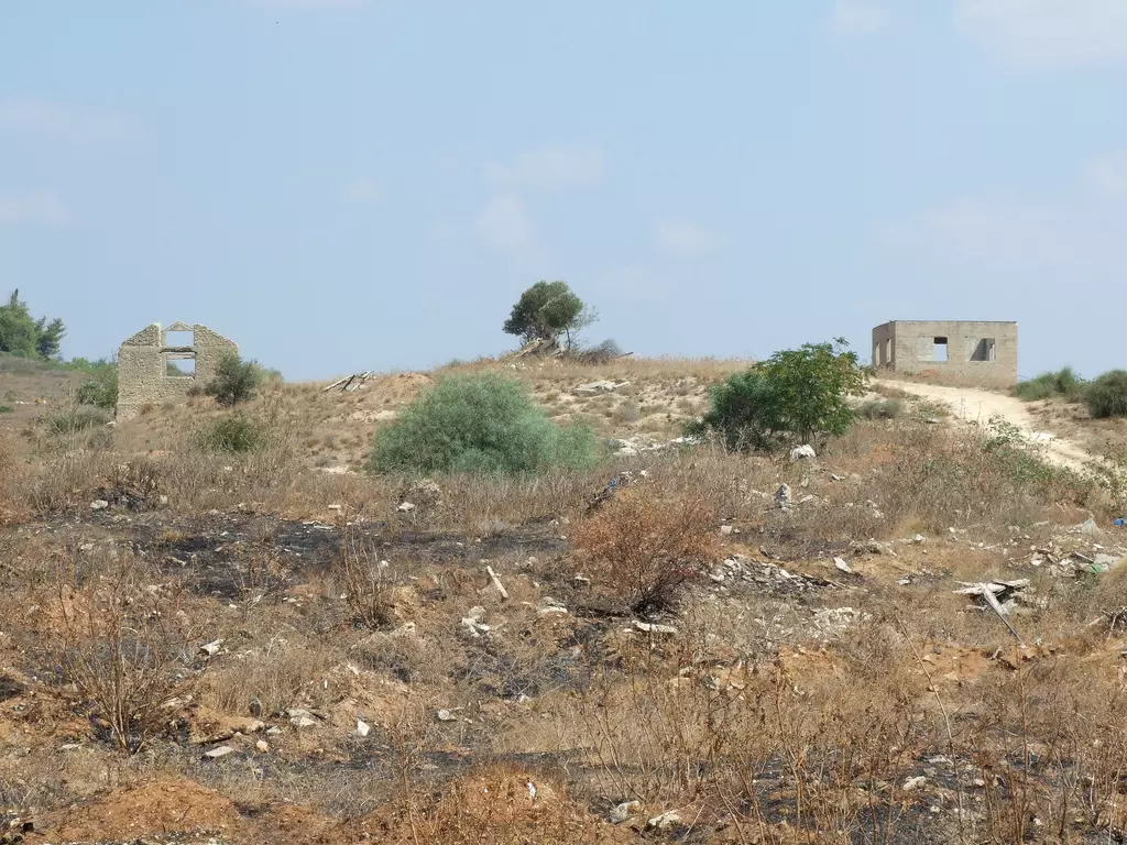
| Village Temains | Sarafand al-Kharab was mostly destroyed with the exception of few houses remain standing and one of its schools. | |||||||||||||||||||||
| Ethnically Cleansing | Sarafand al-Kharab inhabitants were completely ethnically cleansed. | |||||||||||||||||||||
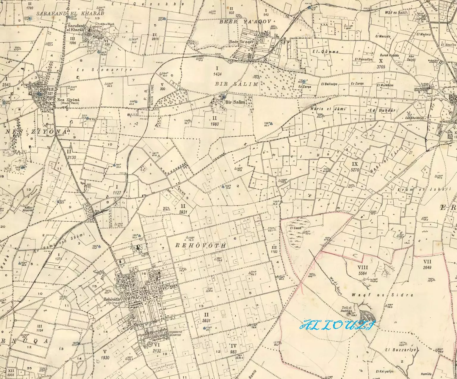
| Pre-Nakba Land Ownership |
**Town Lands' Demarcation Maps |
|||||||||||||||||||||
| Land Usage As of 1945 |
|
|||||||||||||||||||||
| Population |
|
|||||||||||||||||||||
| Number of Houses |
|
|||||||||||||||||||||
| Near By Towns |
||||||||||||||||||||||
|
||||||||||||||||||||||
| Schools | An elementary school for boys which was founded in 1920, and in 1945 it had an enrollment of 258 boys. This school was also shared with Wadi Hunayn, Bir Sa1im, and al-Nabi Rubin villages. A girls' school was also established in 1945, and when it opened its doors it had an enrollment of 46 girls (one of the schools remains standing to this date). | |||||||||||||||||||||
| Water Supply | The villagers irrigated their crops from the many artesian wells they had drilled. | |||||||||||||||||||||
| Exculsive Jewish Colonies That Usurped Village Lands |
Nes Tziyyona, Yad Eli'ezer, and Beyt Chanan. | |||||||||||||||||||||
| Featured Video | ||||||||||||||||||||||
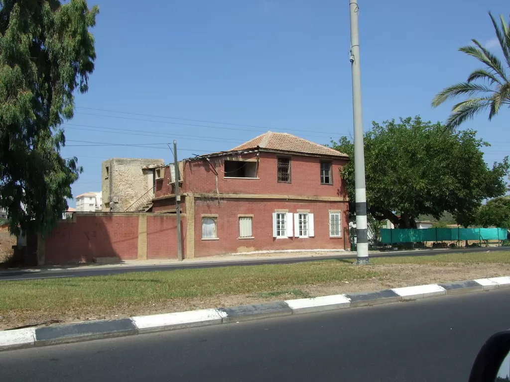
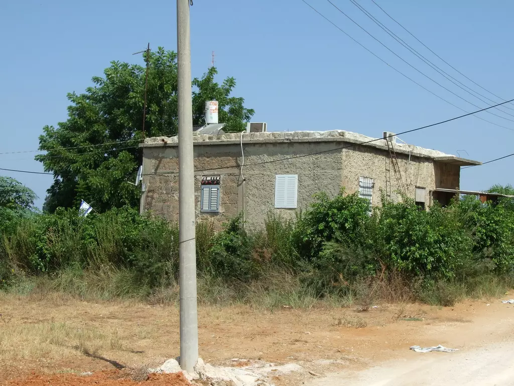
Village Before NakbaThe village stood on a flat spot in the middle of the coastal plain. It was linked by a spur to a highway to the west that intersected with a highway between Ramla and Jaffa. It was also known as Sarafand al-Sughra ('the smaller Sarafand'), to distinguish it from its larger sister village, Sarafand al-Kubra ('the larger Sarafand'), 5 km to the northeast. Sarafand al-Sughra has been identified with an unnamed Crusader locality, based on the evidence of architectural remnants (vaults) in the village. It was probably inhabited in the sixteenth century; the fact that Ottoman records list a 'Sarafand al-Kubra' suggests that this village's smaller counterpart, Sarafand al-Sughra, also existed in 1596. The Egyptian Sufi traveler Mustafa al-Dumyati (d. 1764) reported visiting the shrine of Luqman in Sarafand (see Sarafand al-'Amar). The village may have acquired the name Sarafand al-Kharab ('Sarafand of the ruins') in the early nineteenth century. When Edward Robinson passed by the area in 1838, he reported that there were two villages with the name of Sarafand, one of which was inhabited and the other ruined. The latter was probably Sarafand al-Kharab. The village was repopulated during the late nineteenth century, as is indicated by the maps of the Survey of Western Palestine .During the late 1920s Sarafand al-Kharab was briefly reduced to ruins once again, after British forces burned it. This was in retaliation for the killing of British soldiers who had entered the village drunk, violating the sensibilities of the inhabitants and, apparently, committing some offense that enraged the villagers. Many of them were displaced by this incident, and some of them settled, at least temporarily, in adjacent villages. After some time, however, the village recovered and was rebuilt. Its houses were built in rows, attached to each other, and were made of mud and straw or cement. There were 110 Christians among the 1,040 villagers; the rest were Muslims. In 1920 the villagers built their own school; it became a full elementary school with 258 students in the mid-1940s and was attended by students from the neighboring villages of Wadi Hunayn, Bir Salim, and al-Nabi Rubin. The number of students from Wadi Hunayn alone amounted to about one-fourth of the schools' total enrollment. A girls' school was also established in 1945 and had 46 students in that year. Sarafand al-Kharab's economy was primarily agricultural. The villagers irrigated their crops from the many artesian wells they had drilled. Fertile soil and the availability of irrigation water made possible the cultivation of fruits and vegetables, which yielded handsome revenues. Citrus fruits constituted the principal crop; in 1944/45 a total of 3,148 dunums was devoted to citrus and bananas and 268 dunums were allocated to cereals; 49 dunums were irrigated or used for orchards. Village Occupation and Ethnic CleaningIsraeli historian Benny Morris indicates that the villagers, fearing a Jewish attack, fled on 20 April 1948. A week before that, on 12 April, a New York Times story quoted 'Jewish sources' as saying that one of their units had struck deep into Arab territory and had blown up twelve houses on the outskirts of Ramla and two neighboring villages. One of those villages may have been Sarafand al-Kharab. An additional factor that prompted the villagers to leave was the Giv'ati Brigade's Operation Nachshon (see Bayt Naqquba, Jerusalem sub-disctrict), which led to the massacre of Deir Yasin (Jerusalem sub-disctrict) on 9 April. But the village may not have come under Israeli occupation until mid-May (around the same time as its sister village of Sarafand al-'Amar and neighboring Bir Salim were occupied).Zionists Colonies on Village LandsZionists established the settlement of Nes Tziyyona (130148) in 1882; it is now a large town, and many of its buildings are on the village land of Sarafand al-Kharab. Yad Eli'ezer (131149), established in the early 1950s, is on village land but is no longer a separate, distinct locality. It was named after Eliezer Margolin, a commander of the British army's Jewish Legion during World War I who, disobeying orders, allowed his troops to use British weapons from the military base in Sarafand al-'Amar against Palestinian nationalists in 1921. The settlement of Beyt Chanan (128149), to the west of the site, was established in 1948; although close by, it is not on village lands.Village TodayA major part of the village has been destroyed. Many houses, however, remain; no more than six of them, including the house of Muhammad Darwish, are occupied by Israeli families. Most of them have gable roofs and rectangular doors and windows. One house is comprised of two-story and has a slanted roof. The school is used by Israeli students. A pond and a pump house in the orchard of Mahmud Yusuf Darwish are still undamaged. Castor oil (ricinus) plants and mulberry trees grow on the site. The cemetery is overgrown with cactus plants. The surrounding lands are cultivated by Israelis.SourceDr. Walid al-Khalidi, 1992: All That Remains. |
||||||||||||||||||||||
| Related Maps | Town Lands' Demarcation Maps خرائط للقضاء توضح حدود القرى والاودية Town's map on MapQuest View from satellite Help us map this town at WikiMapia |
|||||||||||||||||||||
| Related Links | Wikipedia's Page Facebook Page Google Search Google For Images Google For Videos |
|||||||||||||||||||||
| More Information | في كتاب كي لا ننسى في كتاب بلادنا فلسطين المزيد من موقع هوية |
|||||||||||||||||||||
- سبب التسمية
- مجزرة وقعت في صرفند
- مجزرة اخرى
- شهادة
- الشهيد علي مصطفى ابو رزق(حمدان)
- معركة صرفند
- كمين للمجاهدين
- حكايت ركبها
- حكاية ركبها الحقيقية
- الشهيد محمد حمدان
- عائلة الغاوي من صرفند الخراب مهددة بالطرد من بيتها في القدس
- اللواء الشهيد توفيق جبر .. كسرت رتبته من عباس، فكان على رأس الشهداء
- تخريج دورة الشهيد الملازم أول عبد القادر حمدان ابن صرفند الخراب
- قصيدة كتبها الاخ سليم الزعنون في الشهيد عبد القادر حمدان وفي عائلة حمدان وفي صرفند الخراب بشكل عام
- انظروا في اي مرتبة جائت عائلة حمدان من حيث تقديمها للشهداء في دراسة اجريت ونشرت في صحيفة معا الالكترونية
- Massacre that stained the Light Horse
- قصة مذبحة صرفند الخراب يرويها على محمد ابراهيم(ابو باسم الصرفندي) نقلا عن جدته
- مقال في محرقة صرفند الخراب بقلم علي الصرفندي
- كي لا ننسى …مع الباحث يحيى الصرفندي ودراسته حول قريته: صرفند الخراب «صرفند الجديدة »..قضاء الرملة
- قصة طمع وشجع
- Palestine Chronicle: The Sarafand Massacre, and Cover-up By Vacy Vlazna
- نبذة تاريخية عن قرية صرفند الخراب (قضاء الرملة) من كتاب (
كي لا ننسى )
- المجاهد اسماعيل محمد سليم ابراهيم ابطال ثورة 1936
Posted by ياسر 10 - الشهيد البطل اللواء توفيق جبر ابن صرفند الخراب اول شهيد في حرب غزة

Posted by احمد حمدان 2 - قال عنه يوم الشهيد ياسر عرفات في بيروت ابان الحصار .... لو وقف توفيق لينظم السير لاجبر الدبابات على التوقف
Posted by احمد حمدان 1 - الشهيد اللواء توفيق جبر ينظم السير قبل استشهاده بايام

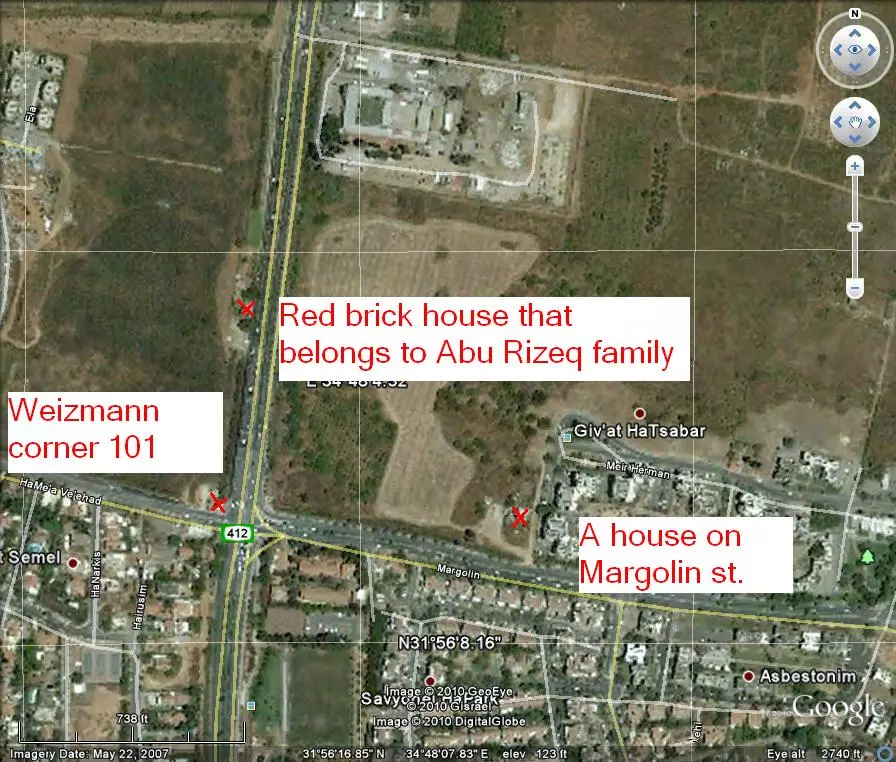
Posted by احمد حمدان 1 - Two houses on a hill, west of Be'er Ya'akov
Posted by Uri Zackhem 1 - A third house, further to the west

Posted by Uri Zackhem 2 - Sabar (cactus) hill, on which used to be the cemetery. Now its a public garden & buildings.
Posted by Uri Zackhem 3 - A building on the road to Rishon LeTzion. Belongs to Abu Rizeq family. Inhabited by Jews.
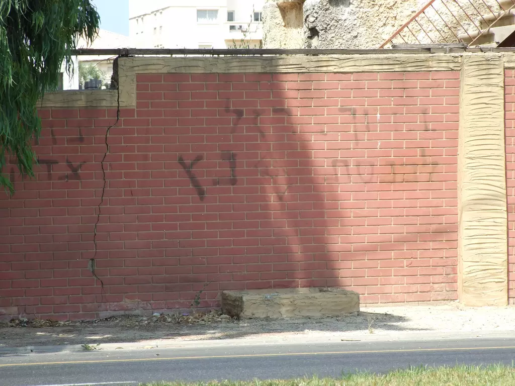
Posted by Uri Zackhem 3 - A graffitti calling for the election of the Judeo-Nazi Baruch Marzel to the knesset.
Posted by Uri Zackhem - A building on 101 [unit] and Weizmann St. The 101 commando gang headed by Sharon perpetrated many war crimes.
Posted by Uri Zackhem - The entrace (Weizmann corner 101)
Posted by Uri Zackhem - A house on Margolin st. close to the corner with Weizmann.
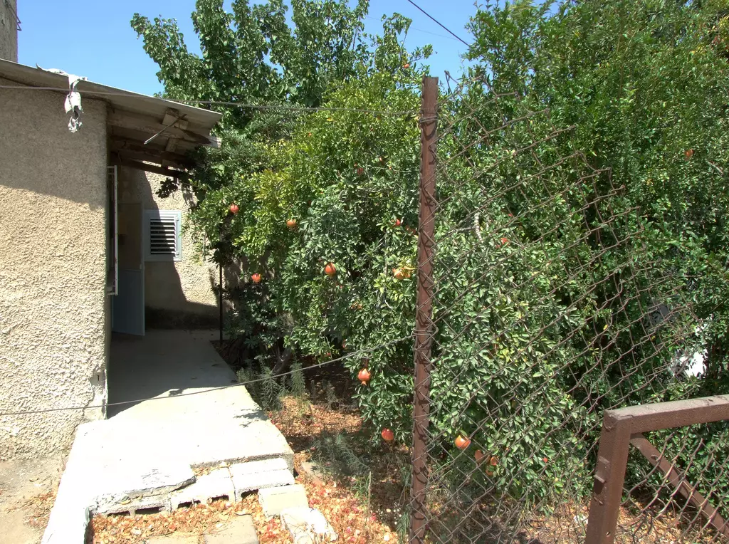
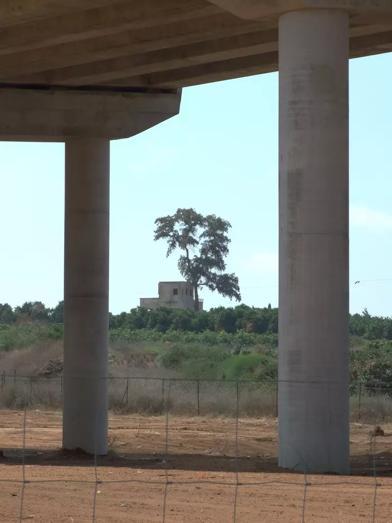
Posted by Uri Zackhem 2 - A house in an orchard, a look under highway 431 between Be'er Ya'akov & Nes Tziona.
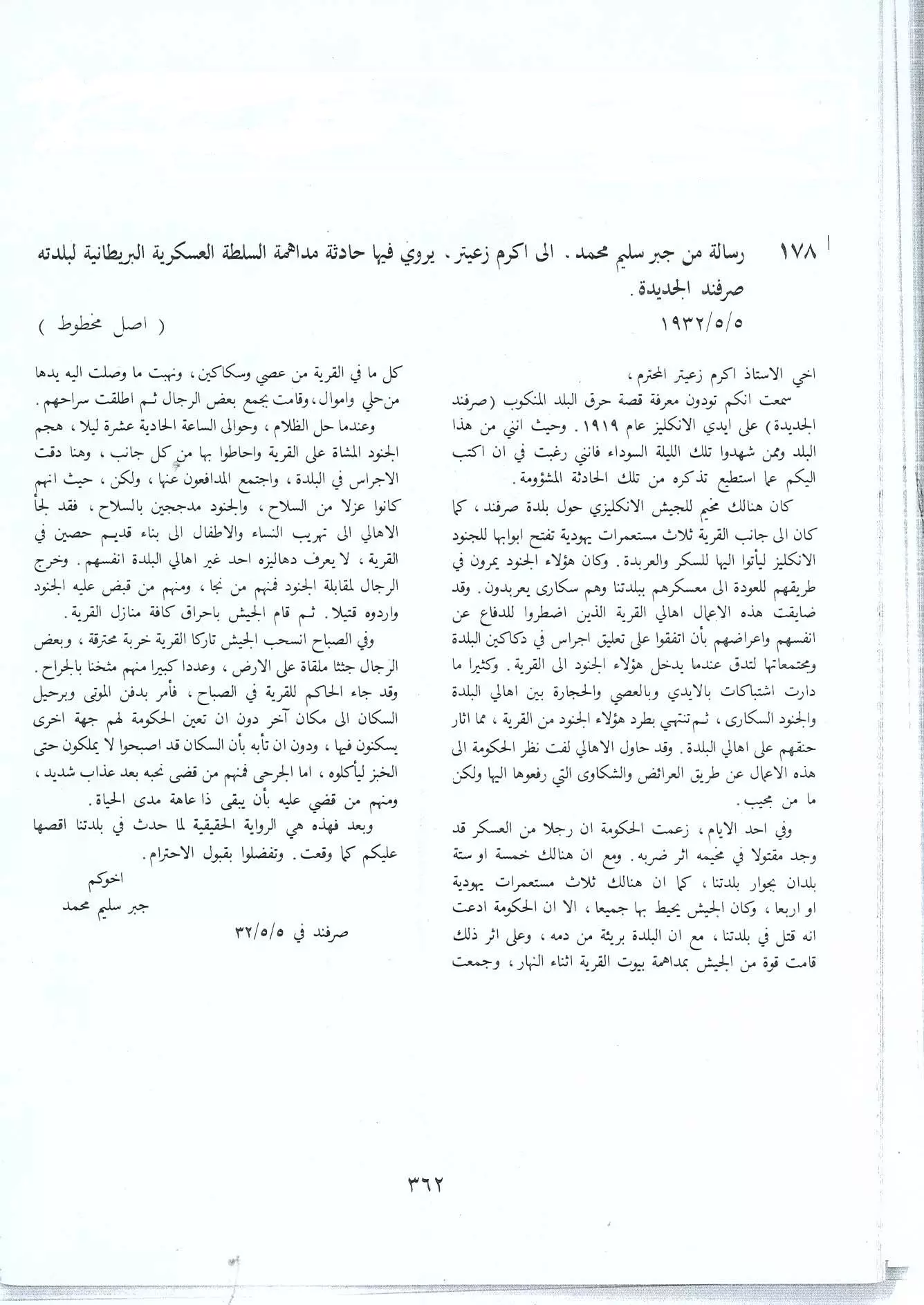
Posted by Uri Zackhem 1 - قصة مذبحة صرفند كما يرويها المرحوم جبر سليم محمد لاكرم زعيتير في اوراقه-تصوير الاستاذ يحيى ابراهيم الصرفندي
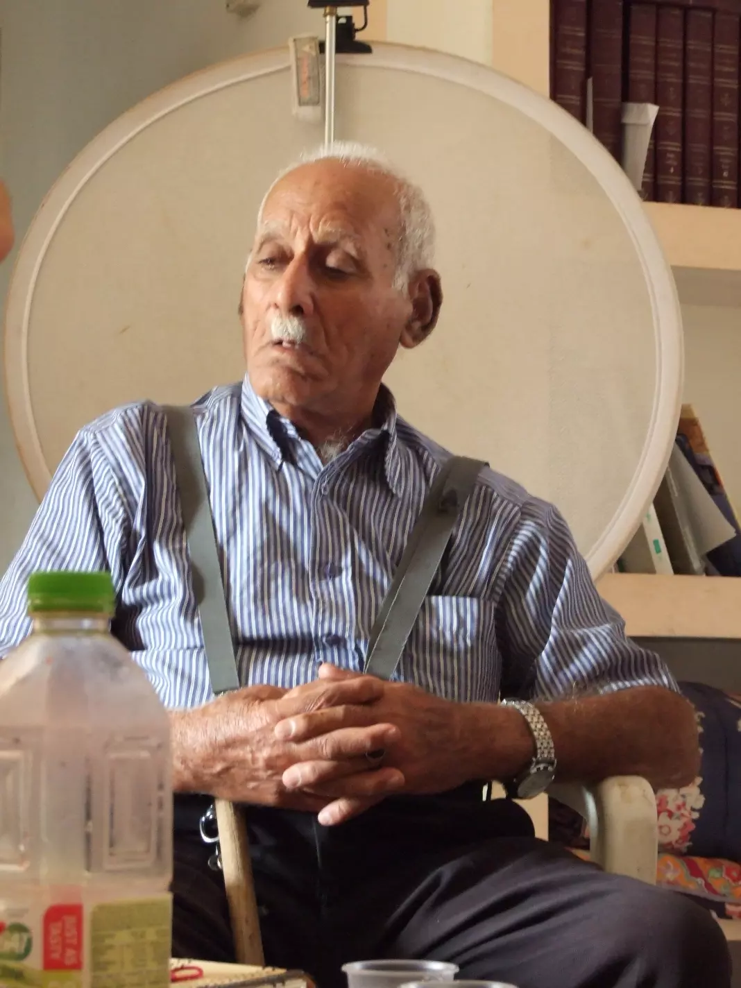
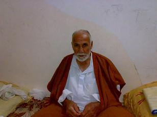
Posted by حكمت زكي - Muhammad Abu Rizeq, born 1917, survivor of the Sarafand massacre, perpetrated by NZ, Autralian & Scottish soldiers right after WW1 ended
Posted by Uri Zackhem 1 - الحاج حسن حسين العويني من أهالي صرفند الخراب وهو يسكن مدينة خان يونس في قطاع غزة وعمره 82 عاماً ويسلم على جميع أهالي صرفند
Posted by عمر 12 - Orientation
Posted by Uri Zackhem 1 - قرية صرفند - تصوير جوي 1947

Posted by صفافي أصيل - خارطة صرفند الخراب والاراضي التي حولها عام 1930
Posted by hussein abdo 1 - موقع القريه

Posted by abu raya - الربيع في الصرفند

Posted by abu raya - من موقع القريه

Posted by abu raya - اراضي القريه ومستوطنه نيس تسيونا

Posted by abu raya - صرفند الخراب

Posted by abu raya - مجد صرفند

- Former police station in Sarafand al-Kharab, 2020

- Former police station in Sarafand al-Kharab, 2020 #2

-
نقل المعلمة فاطمة الدن من مدرسة صرفند الخراب الى مدرسة بنات جولس -- 24/08/1946

- مجموعة من الوثائق التي تخص تعين المعلمة فاطمة الدن -- من الرملة - في مدرسة صرفند الخراب -- أنقر الصورة لتكبيرها -- 1945 الى 1948

Want to browse more? 80,000 pictures were grouped in these gallaries:
| Display Name | Clan/Hamolah | Country of Residence |
| يعقوب درويش ابراهيم | ابراهيم | Michigan, USA |
| fayaz anbar | - | damascus syria, damascus syria |
| abu malik | - | indiana, usa |
| موسى حمدان | حمدان | عمان/الاردن, الاردن |
| ابومحمد | - | السعوديه, السعوديه |
| em rashed | hamdan | jordan, jordan |
| Anas Alghawi | الغاوي | Jordan, Jordan |
| عزمي حمدان | Hamdan | Jordan, Jordan |
| بسام رزق أبو رزق | أبو رزق | عمان - المملكة الاردنية الهاشمية, Palestine |
| رياض ذيب عبدالله حمدان | حمدان | السعوديه, السعوديه |
| قصي إبراهيم | ابراهيم | الاردن |
| majdi issa hamdan | Hamdan | riyadh, Jordan |
| فلسطينيه وبفتخر | نور الدين | جده, السعوديه |
| maher anbar | anbar | - |
| Abu Ramzy | ibrahim | California, USA |
| فؤاد وائل فؤاد | حمدان | - |
| نادر صالح | الصالح / حمدان | الزرقاء, الاردن |
| مريم جمال حمدان | - | الكويت, الكويت |
| زينب حمدان | - | الكويت, الكويت |
| رائد حمدان | - | عمان, الاردن |
| نور فلسطين | - | الكويت, الكويت |
| غازي | صرفند الخراب | الاردن, عمان |
| رائد سمير حمدان | حمدان | المصيون |
| عرفات احمد حمدان | حمدان | jerusalem-silwan |
| توفيق يحيى حمدان | حمدان | jerusalem-kalandia |
| ثائر يحيى حمدان | حمدان | jerusalem-kalandia |
| HAMDAN3 | - | - |
| HAMDAN2 | - | - |
| محمد يحيى حمدان | حمدان | القدس |
| ياسر ابراهيم | - | عمان, الاردن |
| نهاد ابراهيم ابراهيم | ال ابراهيم | - |
| يزن ابراهيم | - | عمان, الاردن |
| وداد بدير | - | - |
| tala tayseer ibrahim | - | عمان, الأردن |
| سليم ابراهيم | ابراهيم | - |
| أبوماجد | حمدان | - |
| اياد محمد حمدان حمدان | حمدان | DOHA, قطر |
| Hisham Riad Hamdan | Hamdan | Riyadh, Riyadh |
| احمد حمدان | حمدان | - |
| shawki mohammad hamdan | hamdan | nasr city, egypt |
| hamada76 | Hamdan | Canada |
| ابراهيم | ابراهيم | - |
| احمد حمدان | حمدان | - |
| حكمت زكي | جاد الله | palestine, بيت عور |
| teisir ibrahim | - | - |
| YOUSEF ANBAR | anbar | - |
| mahmud alsahli | ALSAHLI | DAMASCUS, SYRIA |
- كل ما تبقى من صرفند الخراب منذ النكبة Duration: 4 min 38 sec
- Histroian Nicholas Boyak calls on the Newzeland government to applogies for the Sarfand's massacre Duration: 4 min 59 sec
 Fake Valor: Why Did Zionist Jews Hoist Nazis Flag on Their Ships in the 1930s?
What is new?
-
Facts About Oct. 7th Gaza Raid
-
Remined Us Please: Who Did Rape Whom? Was it Palestinians who raped Israelis? Or, was the other way around? You'll be the judge
-
When Prof. Edward Said was invited to debate Bibi Netanyahu in the 1980s, watch what happened!
-
Ezra Klein of the NY Times on the "Jewish Race".
-
Abusing Blood Libel!
-
How and why Israeli Jewry has become the most hated cult?
-
Did Israeli Soldiers Activate The Hannibal Direective On Oct. 7th? You Be The Judge
-
Zionist FAQ: Isn't it true that Palestinians don't want peace? Palestinians never accepted the two-state solution
- Facts about Haavara (Transfer) Agreement between Ben-Gurion & Hitler
-
Haavara FAQs: Why Did Zionist Jews Hoist Nazis' Flags on Their Ships in the 1930s?
- Haavara FAQs: When Chaim Weizmann met FDR in mid-1943, why was he silent about rescuing European Jewry?
-
Dear ChatGPT: How did Palestinians resist Napoleon's invasion of their country in 1799?
-
Dear ChatGPT: Gaza had a vibrant Jewish community in the mid-17th century. What happened to them?
-
Dear ChatGPT: Why did the Jewish Agency suppress news of the Holocaust during WWII?
-
Video Playlist: Jews share their DNA tests to end the conflict for good.
-
A Tale of Two Conflicts: Examining the Definition of Genocide
-
Prof. Abraham Polak And The Suppressed History of the Khazars and European Jewry
-
How Ronald Reagan would have framed the genocide in Gaza if he were still alive?
-
Haavara FAQs: Let us do the math: how many German Jews did The Haavara Agreement save?
-
Zionist FAQs: The Hebron Massacre of 1929, "clearly proves" that Palestinians are antisemitic, how could you deny it?
-
Zionist FAQs: Why Anti-Zionist Is Not Antisemitism?
-
Zionist FAQs: Isn't it true that the KGB created Palestinian Nationalism in the early 1960s?
- Zionist FAQs: Muslims are killing Muslims all the time; why are Israeli Jews being singled out in the media?
- Zionist FAQs: How is Israel an apartheid state when 20% of its citizens are Arabs who enjoy full rights?
-
Haavara FAQs: Why Did Dorothy Thompson Flip From A Zionist Advocate to A Silenced Dissenter?
-
Haavara FAQs: Analysis of Herzl's Uganda Scheme and how it could have saved millions of Jews.
-
Haavara FAQs: Why did Hayim Greenberg describe American Jewry as "morally bankrupt" in early 1943?
-
Haavara FAQs: What if the Evian Conference was a resounding success? What would have been the impact of saving European Jewry on Zionism?
- Haavara FAQs: What if the six million were saved, how that would have impacted the Zionist project?
-
Haavara FAQs: How did Zionist leaders react when Europe's Jews lingered in the DP camps after WWII ended?
-
Why does the American Jewish community repeat lies that David Ben-Gurion had debunked before he died?
-
Who has the power to rename the Tatar/Khazar Gene Marker to Jewish IV?
-
Zionist FAQs: Why won't Egypt, Syria, and Jordan take their people back? Jews are indigenous to Palestine, and Arabs immigrated after Jews developed the country. Arabs should leave.
-
Haavara FAQs: Did Hitler and the Nazis conflate between Judaism and Zionist? If that wasn't case, then why?
-
Haavara FAQs: Winston Churchill and antisemitism, a collection of articles written Churchill.
-
Haavara FAQs: Broken by country, how many Jews survived vs. killed during the Holocaust?
-
Haavara FAQs: Why did European Jews vote with their feet and to immigrated to the Americas, not Palestine, after WWII?
-
Watch this American Jewish Girl describing Israeli Jews' cognitive dissonance like no other in under two minutes
-
Haavara FAQs: When the Nazis went out of their way to hide the Holocaust, Israeli Jews did the exact opposite by broadcasting their genocide of Gazans. But why?
-
Haavara FAQs: How Zionist Jews went out of their to show their appreciation to Nazism and Fascism?
- Haavara FAQs: Why Zionist leaders were against bombing the death camps & the Railroads leading to them?
-
Haavara FAQs: Hitler's message to the British and American people: If Jews are such noble citizens and you care about them, how come you're not letting them in? I will gladly ship them to you at my expense, even on luxury liners!
-
A shortlist of Zionist and Israeli false flag operations in the name Jews.
-
The Most Moral Army
- The Land of Kapos (Israel): Where the brave are boycotted and Kapos walk free.
- Why did early Zionists often named their communal enterprises "colonial"?
- Zionist Relations with Nazi Germany by Faris Glubb
-
Two NY Times advertisements by Zionists in the early 1943 that exposes Zionists' treason at the height of the calamity
- Facts Not Lies about the Palestinian-Israeli Conflict.
- Site's pictures have been categorized
- Campgain Against Lice
- A Survey of Palestine, the official source about Palestine before Nakba produced by the British Mandate; over 1200 pages.
- Satellite View & Google Earth: Over 6,000 placemarks identifying all destroyed towns, W. Bank & Gaza Strip Towns, & refugee camps.
- PalestineRemembered.com and its Nakba Oral History Project were featured on al-Jazeera Satellite TV.
- Nakba Oral History Video Podcast:
 Over 700 Oral History interviews (including 3,500+ hours of recording) can be viewed online.
 - Palestine Village Statistics Project
- Gaza Jail Break
- النسخة العربية للموقع الان متوفرة
- Videos: Documenting the destroyed villages in video: Tracing all that remains since Nakba.
- Videos: Responding to Zionist Propaganda
- Interview: The ethnic cleansing of Palestine: George Galloway interviews Israeli Historian Ilan Pappe.
- For Palestinians, memory matters. It provides a blueprint for their future By George Bisharat.
- Zionist FAQ now available in Hebrew שאלות שציונים שואלים, עכשיו בעברית
- Video: The Stephen Walt and John Mearsheimer report on the influence of the Israel Lobby on U.S. Foreign Policy
- The Palestinian-Israeli conflict for beginners
