| PalestineRemembered | About Us | Oral History | العربية | |
| Pictures | Zionist FAQs | Haavara | Maps | |
| Search |
| Camps |
| Districts |
| Acre |
| Baysan |
| Beersheba |
| Bethlehem |
| Gaza |
| Haifa |
| Hebron |
| Jaffa |
| Jericho |
| Jerusalem |
| Jinin |
| Nablus |
| Nazareth |
| Ramallah |
| al-Ramla |
| Safad |
| Tiberias |
| Tulkarm |
| Donate |
| Contact |
| Profile |
| Videos |
Welcome To al-Haditha - الحديثة (אל-חדית'ה)
|
District of al-Ramla
Ethnically cleansed days ago |
العربية Google Earth |
 |
Gallery (48) |
- Statistics & Facts
-
Before & After

- Satellite View
- Articles 3
- Pictures 48
- Oral History 3
- Members 19
- All That Remains
- Wikipedia
- Videos 1
- Guest Book 92
- Links
| Statistic & Fact | Value | ||||||||||||||||||||||||
| Occupation Date | July 12, 1948 | ||||||||||||||||||||||||
| Distance From District | 8 (km) Northeast of al-Ramla | ||||||||||||||||||||||||
| Elevation | 125 (meters) | ||||||||||||||||||||||||
| Before & After Nakba, Click Map For Details |
|||||||||||||||||||||||||

|
|||||||||||||||||||||||||
| Map Location | See location #8 on the map View from satellite |
||||||||||||||||||||||||
| Military Operation | First stage of Operation Dani | ||||||||||||||||||||||||
| Exodus Cause | Military assault by Zionist troops | ||||||||||||||||||||||||
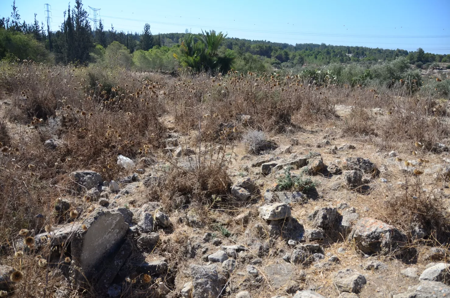
| Village Temains | On September 14th, 1948, al-Haditha was mostly destroyed with the exception of one house remain standing. | ||||||||||||||||||||||||
| Ethnically Cleansing | al-Haditha inhabitants were completely ethnically cleansed. | ||||||||||||||||||||||||
| Pre-Nakba Land Ownership |
**Town Lands' Demarcation Maps |
||||||||||||||||||||||||
| Land Usage As of 1945 |
|
||||||||||||||||||||||||
| Population |
|
||||||||||||||||||||||||
| Number of Houses |
|
||||||||||||||||||||||||
| Near By Towns |
|||||||||||||||||||||||||
|
|||||||||||||||||||||||||
| Town's Name Through History | In Biblical times, al-Haditha was referred to by Hadid, and during the Hellenistic it was known by 'Adida. | ||||||||||||||||||||||||
| Schools | An elementary school for boys which was founded in 1924, and in 1945 it had an enrollment of 42 students. | ||||||||||||||||||||||||
| Nearby Wadies & Rivers | al-Haditha is situated on the west bank of Wadi al-Natuf. | ||||||||||||||||||||||||
| Exculsive Jewish Colonies That Usurped Village Lands |
Chadid | ||||||||||||||||||||||||
| Featured Video | |||||||||||||||||||||||||
Village Before NakbaThe village was situated on a hilly spot on the eastern edge of the central coastal plain, on the west bank of Wadi al-Natuf. It was 1 km east of a main road connecting Lydda, Bayt Nabala, and other villages farther north and was linked to it by a secondary road. Al-Haditha was also connected by secondary roads to a number of neighboring villages. It has been identified with the Biblical locality of Hadid (Ezra 2:33), where 720 Jewish exiles returning from Babylon were settled. The site may have been the Hellenistic 'Adida which was fortified by Simon Maccabeus (1 Maccabees 12:38). Architectural fragments in the village attest to its long history. The Byzantine historian Eusebius (A.D. 260-339), who was born in Palestine (Caesarea), wrote that the village was east of Lydda. In the nineteenth century the French traveller Guérin, who visited Palestine several times, wrote that al-Haditha stood on top of a hill and consisted of several houses.Al-Haditha originally had a trapezoidal layout that became rectangular, toward the end of the Mandate, as the village expanded. Its houses were clustered around the center, which contained a mosque, a small marketplace, and an elementary school, founded in 1924, which had an enrollment of forty-two students in 1943. All of the people living in al-Haditha were Muslims. Their main economic activity was agriculture, and their most important crops were grain and olives. In 1944/45 a total of 10 dunums was devoted to citrus and bananas and 4,419 dunums were allotted to cereals; 246 dunums were irrigated or used for orchards, of which about 200 dunums were olive groves. Village Occupation and Ethnic CleaningAI-Haditha was occupied on 12 July 1948, while the occupation of Lydda and Ramla was in progress. This occurred in the first stage of Operation Dani (see Abu al-Fadl, Ramla sub-district). Two months after its occupation, on 14 September, Israeli prime minister Ben-Gurion consigned it to partial destruction 'because of a lack of manpower to occupy the area [in depth].' In accordance with a newly-instituted procedure, Ben-Gurion asked a special ministerial committee, formed to oversee the demolition of villages, to approve the destruction of al-Haditha.Zionists Colonies on Village LandsThe settlement of Chadid (143152) was established in 1950 on village lands, 2 km northwest of the ruins of the destroyed village.Village TodayThe stone and concrete rubble of destroyed houses is visible on the site. Only one house remains; it is sealed and deserted. It has a gabled, tiled roof, and a sign ("BROADWAY 80") is glued to one of its walls. There are also clusters of trees on the site, including Christ's-thorn, olive, and eucalyptus trees. The old village road remains and has been enlarged. The surrounding land is cultivated.SourceDr. Walid al-Khalidi, 1992: All That Remains. |
|||||||||||||||||||||||||
| Related Maps | Town Lands' Demarcation Maps خرائط للقضاء توضح حدود القرى والاودية Town's map on MapQuest View from satellite Help us map this town at WikiMapia |
||||||||||||||||||||||||
| Related Links | Wikipedia's Page Facebook Page Google Search Google For Images Google For Videos |
||||||||||||||||||||||||
| More Information | في كتاب كي لا ننسى في كتاب بلادنا فلسطين المزيد من موقع هوية |
||||||||||||||||||||||||
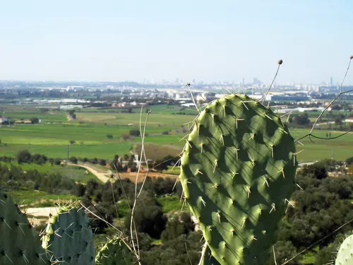
- منظر لتل ابيب من فوق تل حاديد(الحديثة) تظهر الموقع الاستراتيجي للقرية
Posted by محمود حسن ابراهيم خليل محفوظ - ابو حمزة 5 - أشبال جمعية ديرتنا يقفون أمام الكتاب المهدوم

Posted by محمد سلامة يونس - عدسة محمد يونس تلتقط نشطاء ديرتنا يزورون موقع قرية الحديثة- 15 أيار 2009

Posted by محمد سلامة يونس 1 - بير من الحديثة

Posted by جلال عطشان 2 - Panorama in sandstorm, top of the hill

Posted by Uri Zackhem - An Israeli sign mentioning the village briefly.

Posted by Uri Zackhem - A cistern

Posted by Uri Zackhem - A cistern

Posted by Uri Zackhem 5 - A cistern

Posted by Uri Zackhem - A cistern

Posted by Uri Zackhem - A cistern

Posted by Uri Zackhem 2 - A cistern

Posted by Uri Zackhem - A cistern

Posted by Uri Zackhem - زيتون الحديثة

Posted by محمود حسن ابراهيم خليل محفوظ - ابو حمزة - المرحوم الحاج محمود الاسمر في بلدة الحديثة

Posted by ABDULLAH ALASMAR - Sheep and goats of a refugee from Khalsa (Safad subdistrict)

Posted by Uri Zackhem - Rubble
Posted by Uri Zackhem - Rubble

Posted by Uri Zackhem - A wall

Posted by Uri Zackhem - The cemetery

Posted by Uri Zackhem - A grave

Posted by Uri Zackhem - Autumn

Posted by Uri Zackhem - منظر عام للقريه واراضيها

Posted by abu raya - اراضي القريه وفي الافق تل ابيب

Posted by abu raya - حقول زيتون القريه

Posted by abu raya - اراضي القريه

Posted by abu raya - زيتون القريه

Posted by abu raya - اطلال القريه

Posted by abu raya - زيتون القريه

Posted by abu raya - Let us see how the most "liberal and civilized" of world Jewry has obliterated our village. How else will the Jews be great and safe again?

- Let us see how the most "liberal and civilized" of world Jewry has obliterated our village. How else will the Jews be great and safe again? #2

- Let us see how the most "liberal and civilized" of world Jewry has obliterated our village. How else will the Jews be great and safe again? #3

- Let us see how the most "liberal and civilized" of world Jewry has obliterated our village. How else will the Jews be great and safe again? #4

- Let us see how the most "liberal and civilized" of world Jewry has obliterated our village. How else will the Jews be great and safe again? #5

- Let us see how the most "liberal and civilized" of world Jewry has obliterated our village. How else will the Jews be great and safe again? #6

- Let us see how the most "liberal and civilized" of world Jewry has obliterated our village. How else will the Jews be great and safe again? #7

- Let us see how the most "liberal and civilized" of world Jewry has obliterated our village. How else will the Jews be great and safe again? #8

- Let us see how the most "liberal and civilized" of world Jewry has obliterated our village. How else will the Jews be great and safe again? #9

- Let us see how the most "liberal and civilized" of world Jewry has obliterated our village. How else will the Jews be great and safe again? #10

- Let us see how the most "liberal and civilized" of world Jewry has obliterated our village. How else will the Jews be great and safe again? #11

- Let us see how the most "liberal and civilized" of world Jewry has obliterated our village. How else will the Jews be great and safe again? #12

- Let us see how the most "liberal and civilized" of world Jewry has obliterated our village. How else will the Jews be great and safe again? #13

- Let us see how the most "liberal and civilized" of world Jewry has obliterated our village. How else will the Jews be great and safe again? #14

- Let us see how the most "liberal and civilized" of world Jewry has obliterated our village. How else will the Jews be great and safe again? #15

- Let us see how the most "liberal and civilized" of world Jewry has obliterated our village. How else will the Jews be great and safe again? #16

- آبار القرية

- آبار القرية #2

- آبار القرية #3

Want to browse more? 80,000 pictures were grouped in these gallaries:
| Display Name | Clan/Hamolah | Country of Residence |
| Abdallah Alasmar Wadiha | - | Palestine |
| يوسف العطشان | العطشان | عمان, الاردن |
| احمد جميل عوض الله | - | نعم |
| fathi | - | annam |
| rebhey gieth | غيث | عمان, الحديثة |
| رمزي شعبان محفوظ | محفوظ | الرياض, السعودية |
| ابومحمود الاسمر | الاسمر | alhaditha |
| عبدالعزيز علي مسلم عيد | عيد | Saudi Arabia, Saudi Arabia |
| Nijem Mahfoudh | Mahfoudh | Dhahran , Al Hadeetheh |
| مريم | غيث | فلسطين , رام لله - البيرة |
| akram-asmer | alasmer | amman |
| خالد الاسمر | اسمر | albirah, الحديثه |
| محمد حرب درويش مغامس | مغامس | - |
| محمود حسن ابراهيم خليل محفوظ - ابو حمزة | محفوظ | الاردن, الاردن |
| محمود غيث | غيث | رام الله , فلسطين |
| مهند محمد رشيد سعد | سعد | - |
| نضال الحديثي | مغامس | رام لله, الحديثة |
| صالح الاسمر | الاسمر | - |
| Marouf Mughames | - | California, USA |
No links have been shared yet, be free to the first to share the first link.
 Fake Valor: Why Did Zionist Jews Hoist Nazis Flag on Their Ships in the 1930s?
What is new?
-
Facts About Oct. 7th Gaza Raid
-
Remined Us Please: Who Did Rape Whom? Was it Palestinians who raped Israelis? Or, was the other way around? You'll be the judge
-
When Prof. Edward Said was invited to debate Bibi Netanyahu in the 1980s, watch what happened!
-
Ezra Klein of the NY Times on the "Jewish Race".
-
Abusing Blood Libel!
-
How and why Israeli Jewry has become the most hated cult?
-
Did Israeli Soldiers Activate The Hannibal Direective On Oct. 7th? You Be The Judge
-
Zionist FAQ: Isn't it true that Palestinians don't want peace? Palestinians never accepted the two-state solution
- Facts about Haavara (Transfer) Agreement between Ben-Gurion & Hitler
-
Haavara FAQs: Why Did Zionist Jews Hoist Nazis' Flags on Their Ships in the 1930s?
- Haavara FAQs: When Chaim Weizmann met FDR in mid-1943, why was he silent about rescuing European Jewry?
-
Dear ChatGPT: How did Palestinians resist Napoleon's invasion of their country in 1799?
-
Dear ChatGPT: Gaza had a vibrant Jewish community in the mid-17th century. What happened to them?
-
Dear ChatGPT: Why did the Jewish Agency suppress news of the Holocaust during WWII?
-
Video Playlist: Jews share their DNA tests to end the conflict for good.
-
A Tale of Two Conflicts: Examining the Definition of Genocide
-
Prof. Abraham Polak And The Suppressed History of the Khazars and European Jewry
-
How Ronald Reagan would have framed the genocide in Gaza if he were still alive?
-
Haavara FAQs: Let us do the math: how many German Jews did The Haavara Agreement save?
-
Zionist FAQs: The Hebron Massacre of 1929, "clearly proves" that Palestinians are antisemitic, how could you deny it?
-
Zionist FAQs: Why Anti-Zionist Is Not Antisemitism?
-
Zionist FAQs: Isn't it true that the KGB created Palestinian Nationalism in the early 1960s?
- Zionist FAQs: Muslims are killing Muslims all the time; why are Israeli Jews being singled out in the media?
- Zionist FAQs: How is Israel an apartheid state when 20% of its citizens are Arabs who enjoy full rights?
-
Haavara FAQs: Why Did Dorothy Thompson Flip From A Zionist Advocate to A Silenced Dissenter?
-
Haavara FAQs: Analysis of Herzl's Uganda Scheme and how it could have saved millions of Jews.
-
Haavara FAQs: Why did Hayim Greenberg describe American Jewry as "morally bankrupt" in early 1943?
-
Haavara FAQs: What if the Evian Conference was a resounding success? What would have been the impact of saving European Jewry on Zionism?
- Haavara FAQs: What if the six million were saved, how that would have impacted the Zionist project?
-
Haavara FAQs: How did Zionist leaders react when Europe's Jews lingered in the DP camps after WWII ended?
-
Why does the American Jewish community repeat lies that David Ben-Gurion had debunked before he died?
-
Who has the power to rename the Tatar/Khazar Gene Marker to Jewish IV?
-
Zionist FAQs: Why won't Egypt, Syria, and Jordan take their people back? Jews are indigenous to Palestine, and Arabs immigrated after Jews developed the country. Arabs should leave.
-
Haavara FAQs: Did Hitler and the Nazis conflate between Judaism and Zionist? If that wasn't case, then why?
-
Haavara FAQs: Winston Churchill and antisemitism, a collection of articles written Churchill.
-
Haavara FAQs: Broken by country, how many Jews survived vs. killed during the Holocaust?
-
Haavara FAQs: Why did European Jews vote with their feet and to immigrated to the Americas, not Palestine, after WWII?
-
Watch this American Jewish Girl describing Israeli Jews' cognitive dissonance like no other in under two minutes
-
Haavara FAQs: When the Nazis went out of their way to hide the Holocaust, Israeli Jews did the exact opposite by broadcasting their genocide of Gazans. But why?
-
Haavara FAQs: How Zionist Jews went out of their to show their appreciation to Nazism and Fascism?
- Haavara FAQs: Why Zionist leaders were against bombing the death camps & the Railroads leading to them?
-
Haavara FAQs: Hitler's message to the British and American people: If Jews are such noble citizens and you care about them, how come you're not letting them in? I will gladly ship them to you at my expense, even on luxury liners!
-
A shortlist of Zionist and Israeli false flag operations in the name Jews.
-
The Most Moral Army
- The Land of Kapos (Israel): Where the brave are boycotted and Kapos walk free.
- Why did early Zionists often named their communal enterprises "colonial"?
- Zionist Relations with Nazi Germany by Faris Glubb
-
Two NY Times advertisements by Zionists in the early 1943 that exposes Zionists' treason at the height of the calamity
- Facts Not Lies about the Palestinian-Israeli Conflict.
- Site's pictures have been categorized
- Campgain Against Lice
- A Survey of Palestine, the official source about Palestine before Nakba produced by the British Mandate; over 1200 pages.
- Satellite View & Google Earth: Over 6,000 placemarks identifying all destroyed towns, W. Bank & Gaza Strip Towns, & refugee camps.
- PalestineRemembered.com and its Nakba Oral History Project were featured on al-Jazeera Satellite TV.
- Nakba Oral History Video Podcast:
 Over 700 Oral History interviews (including 3,500+ hours of recording) can be viewed online.
 - Palestine Village Statistics Project
- Gaza Jail Break
- النسخة العربية للموقع الان متوفرة
- Videos: Documenting the destroyed villages in video: Tracing all that remains since Nakba.
- Videos: Responding to Zionist Propaganda
- Interview: The ethnic cleansing of Palestine: George Galloway interviews Israeli Historian Ilan Pappe.
- For Palestinians, memory matters. It provides a blueprint for their future By George Bisharat.
- Zionist FAQ now available in Hebrew שאלות שציונים שואלים, עכשיו בעברית
- Video: The Stephen Walt and John Mearsheimer report on the influence of the Israel Lobby on U.S. Foreign Policy
- The Palestinian-Israeli conflict for beginners
