| PalestineRemembered | About Us | Oral History | العربية | |
| Pictures | Zionist FAQs | Haavara | Maps | |
| Search |
| Camps |
| Districts |
| Acre |
| Baysan |
| Beersheba |
| Bethlehem |
| Gaza |
| Haifa |
| Hebron |
| Jaffa |
| Jericho |
| Jerusalem |
| Jinin |
| Nablus |
| Nazareth |
| Ramallah |
| al-Ramla |
| Safad |
| Tiberias |
| Tulkarm |
| Donate |
| Contact |
| Profile |
| Videos |
Welcome To Bayt Tima - بيت طيما (בית טימא)
|
District of Gaza
Ethnically cleansed days ago |
العربية Google Earth |
 |
Gallery (47) |
- Statistics & Facts
-
Before & After

- Satellite View
- Articles 4
- Pictures 47
- Aerial Views 2
- Land Deeds 2
- Members 27
- All That Remains
- Wikipedia
- Videos 3
- Guest Book 41
- Links 1
| Statistic & Fact | Value | ||||||||||||||
| Occupation Date | October 18, 1948 | ||||||||||||||
| Distance From District | 21 (km) North East of Gaza | ||||||||||||||
| Elevation | 75 (meters) | ||||||||||||||
| Before & After Nakba, Click Map For Details |
|||||||||||||||

|
|||||||||||||||
| Pre-Nakba Aerial View |
|||||||||||||||

|
|||||||||||||||
| Map Location | See location #31 on the map View from satellite |
||||||||||||||
| Military Operation | Operation Yo'av | ||||||||||||||
| Attacking Units | Giv'ati Brigade | ||||||||||||||
| Defenders | Egyptian Army | ||||||||||||||
| Acts of Terror | Massacre occured by Zionist troops against the town's inhabitants. | ||||||||||||||
| Exodus Cause | Military assault by Zionist troops | ||||||||||||||
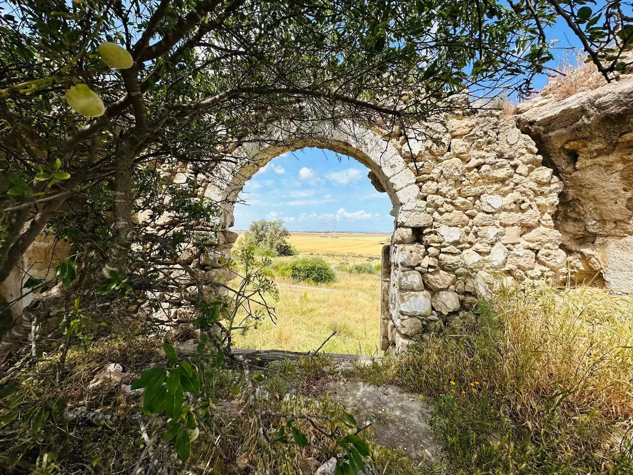
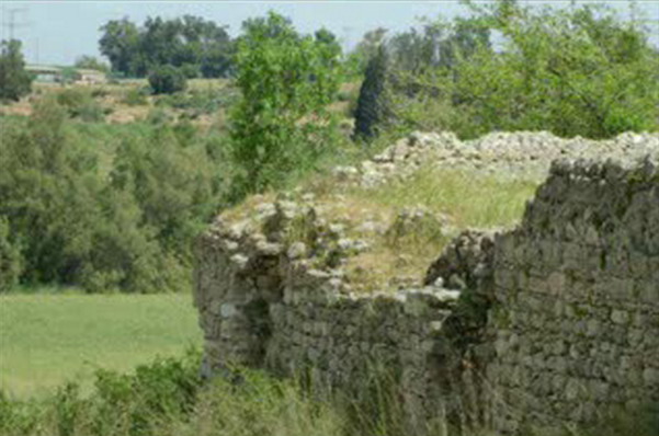
| Village Temains | The village has been completely destroyed, and only house rubble left behind. | ||||||||||||||
| Ethnically Cleansing | Bayt Tima inhabitants were completely ethnically cleansed. | ||||||||||||||
| Pre-Nakba Land Ownership |
|
||||||||||||||
| Land Usage As of 1945 |
|
||||||||||||||
| Population |
|
||||||||||||||
| Number of Houses |
|
||||||||||||||
| Near By Towns |
|||||||||||||||
|
|||||||||||||||
| Schools | In 1946, Bayt Tima shared with the nearby villages of Kawkaba and Hulayqat an elementary school for boys. | ||||||||||||||
| Places of Warship | One Mosque | ||||||||||||||
| Shrines / Maqams | The village had two shrine for a couple of unknown individuals. | ||||||||||||||
| Exculsive Jewish Colonies That Usurped Village Lands |
No settlements on village lands. | ||||||||||||||
| Featured Video | |||||||||||||||
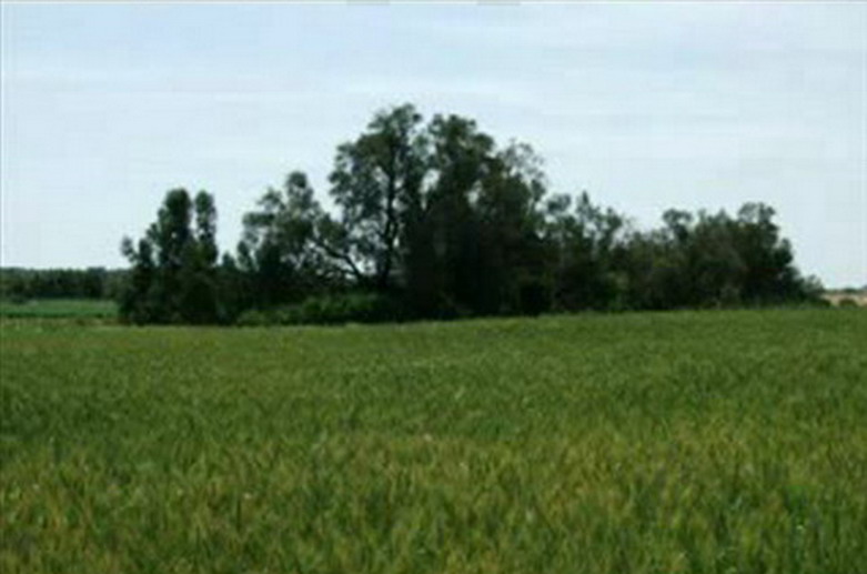
Village Before NakbaThe village was built on flat terrain on the southern coastal plain in a region rich with archaeological artifacts, including some from the Crusades. A secondary road linked it to the coastal highway a short distance to the west, affording it access to Gaza and the city of al-Majdal. In 1596, Bayt Tima was a village in the nahiya of Gaza (liwa' of Gaza), with a population of 693. It paid taxes on a number of crops, including wheat, barley, fruit, almonds, and sesame, as well as on other types of produce, such as goats and beehives.In the late nineteenth century, Bayt Tima was a village of moderate size with two pools and shrines, and two small patches of garden nearby. During the Mandate, the village had its own shops and a mosque, and shared an elementary school, built in 1946, with the neighboring villages of Kawkaba and Hulayqat. Its mud houses were grouped together in blocks, separated by streets or open space; the largest block was at the center of the village. Most of the residents of Bayt Tima were Muslims. They worked mainly in rainfed agriculture, cultivating grain, vegetables, and fruits, especially figs, apricots, and almonds. In 1944/45 a total of 10,444 dunums was allotted to cereals; 197 dunums were irrigated or used for orchards. In the cemetery south of the village a badly worn tessellated (mosaic) pavement was found that suggests a Roman or Byzantine presence. One could also see evidence in the village mosque that architectural elements from earlier times had been reused. Village Occupation and Ethnic CleaningA Zionist attempt to infiltrate Bayt Tima was recorded as early as 9 February 1948, according to the Jaffa-based Palestinian daily Filastin. That attempt was driven back by a hail of bullets from the village's defenders which went on for half an hour.An aerial and artillery bombardment in mid-October 1948 led to the flight of a large number of refugees from Bayt Tima, according to Israeli historian Benny Morris. The village was occupied on 18–19 October, in the early stages of Operation Yoav. The New York Times quoted an Israeli army communiqué on 20 October which said that Bayt Tima had fallen along with Kawkaba and Hulayqat. It was probably captured by the Giv'ati Brigade. Israeli sources had told the Associated Press that they had occupied Bayt Tima at the beginning of June. They claimed they captured it while 'slashing behind an Egyptian coastal spearhead' on 1 June. But the occupation was apparently short-lived, since Israeli forces also threatened Bayt Tima a month later, according to Egyptian writer Muhammad Abd al-Mun'im. He writes that at the end of the first truce, in early July, the village was held by Palestinian militiamen. Israeli forces encroached on the village, occupying the hills overlooking the village, and its defenders were reinforced by a Saudi company fighting on the southern front. It remained in Arab hands throughout the second truce. Zionists Colonies on Village LandsThere are no Israeli settlements on village lands.Village TodaySycamore and carob trees grow around the rubble on the site. The land is used for agriculture.SourceDr. Walid al-Khalidi, 1992: All That Remains. |
|||||||||||||||
| Related Maps | Town Lands' Demarcation Maps خرائط للقضاء توضح حدود القرى والاودية Town's map on MapQuest View from satellite Help us map this town at WikiMapia |
||||||||||||||
| Related Links | Wikipedia's Page Google Search Google For Images Google For Videos |
||||||||||||||
| More Information | في كتاب كي لا ننسى في كتاب بلادنا فلسطين في كتاب النكبة والفردوس المفقود المزيد من موقع هوية |
||||||||||||||
- Relics of Bayt Tima - 15-2-2005

Posted by Haled Iskrur 47 - Fig tree, Bayt Tima

Posted by Uri Zackhem 7 - Remains of a large mansion, Bayt Tima

Posted by Uri Zackhem 5 - Remains of a large mansion, Bayt Tima

Posted by Uri Zackhem 5 - The large mansion from the inside.

Posted by Uri Zackhem 4 - The large mansion from the inside.

Posted by Uri Zackhem 1 - بيت طيما
Posted by أحمد المبحوح - بيت طيما

Posted by أحمد المبحوح 1 - بيت طيما

Posted by أحمد المبحوح 1 - بيت طيما
Posted by أحمد المبحوح 12 - اراضي بيت طيما

Posted by abu raya - بيت طيما

Posted by abu raya - بيت طيما

Posted by abu raya - بيت طيما

Posted by abu raya - بيت طيما

Posted by abu raya - بيت طيما

Posted by abu raya - بيت طيما

Posted by abu raya - بيت طيما

Posted by abu raya - بيت طيما

Posted by abu raya - قريه بيت طيما....صور جديده 2015/10

Posted by محمد ابو عويلى - قريه بيت طيما....صور جديده 2015/10

Posted by محمد ابو عويلى - قريه بيت طيما المهجره....صور جديده 2015/10

Posted by محمد ابو عويلى - قريه بيت طيما....صور جديده 2015/10

Posted by محمد ابو عويلى - قريه بيت طيما المهجره......صور جديده 2015/10

Posted by محمد ابو عويلى - قريه بيت طيما المهجره......صور جديده 2015/10

Posted by محمد ابو عويلى - قريه بيت طيما المهجره......صور جديده 2015/10

Posted by محمد ابو عويلى - قريه بيت طيما المهجره......صور جديده 2015/10

Posted by محمد ابو عويلى - قريه بيت طيما المهجره......صور جديده 2015/10...مسجد القريه

Posted by محمد ابو عويلى - قريه بيت طيما المهجره......صور جديده 2015/10

Posted by محمد ابو عويلى - قريه بيت طيما المهجره......صور جديده 2015/10

Posted by محمد ابو عويلى - قريه بيت طيما المهجره......صور جديده 2015/10

Posted by محمد ابو عويلى - معلومات مهمة عن جامع القرية

Posted by Mohamed ALMabhouh - بيت طيما-١٩٤٨

Posted by أبو اليزن السعافين - الحاجة عائشة جبريل تحتفظ بأوراق الطابو وقواشين الأرض

- الحاجة عائشة جبريل تحتفظ بأوراق الطابو وقواشين الأرض #2

- الحاجة عائشة جبريل تحتفظ بأوراق الطابو وقواشين الأرض #3

- Pre-Nakba Aerial view of the village / صورة من الجو للقرية اخذت قبل النكبة
- جولة بين بيوت القرية المدمرة -- إياد جابر.

- جولة بين بيوت القرية المدمرة -- إياد جابر. #2

- جولة بين بيوت القرية المدمرة -- إياد جابر. #3

- جولة بين بيوت القرية المدمرة -- إياد جابر. #4
- جولة بين بيوت القرية المدمرة -- إياد جابر. #5

- جولة بين بيوت القرية المدمرة -- إياد جابر. #6

- جولة بين بيوت القرية المدمرة -- إياد جابر. #7

- جولة بين بيوت القرية المدمرة -- إياد جابر. #8

- خارطة تُظهِر الحدود والطرق بأنواعها والأماكن المقدسة والطبيعة الطوبغرافية من تلال وسهول ومنحدرات والتشكيلة الطبيعية للأرض وأنواع المزروعات. نُشرت الخريطة فترة الانتداب البريطاني، تم إضافة تعديلات عليها من قِبَل خدمة الخرائط والصور التابعة للقوات العسكرية الاسرائيلية فترة الأربعينيات.

- طلب الجنسية الفلسطينية-فاطمة مخيمر الكرد -- 01/02/1947

Want to browse more? 80,000 pictures were grouped in these gallaries:
- Pre-Nakba Aerial view of the village / صورة من الجو للقرية اخذت قبل النكبة
- خارطة تُظهِر الحدود والطرق بأنواعها والأماكن المقدسة والطبيعة الطوبغرافية من تلال وسهول ومنحدرات والتشكيلة الطبيعية للأرض وأنواع المزروعات. نُشرت الخريطة فترة الانتداب البريطاني، تم إضافة تعديلات عليها من قِبَل خدمة الخرائط والصور التابعة للقوات العسكرية الاسرائيلية فترة الأربعينيات.
| Display Name | Clan/Hamolah | Country of Residence |
| Dr-Yousef | Almabhouh | Dnepropetrovsk, Ukraine |
| BoYChAt | alkurd | oran, algeria |
| الحلم الجميل | اسماعيل | النصيرات, بيت طيما |
| mahmoud | - | جنين |
| النورس الرحال | الكرد | - |
| عبد الكريم سلمان | - | دير البلح, دير البلح |
| ام عكاشة | سلمان | - |
| نعيم الكرد | الكرد | - |
| محمد درويش حرابي | عواد | عمان, الاردن |
| بنت عكاشه سمان | سلمان | السعوديه |
| خالد | - | غزة |
| أبو الأمجد | عواد | غزة |
| زهير ابولبده | - | western, Saudi Arabia |
| Abu Jibryl | - | - |
| refugee | - | palestine |
| *** محمد المبحوح *** | المبحوح | دير البلح, فلسطين |
| barhoma | - | madrid, spenish |
| يويو | لا يوجد | فلسطين, فلسطين |
| muazfadi | عواد | بيت طيما, فلسطين |
| وطني | الكرد | , فلسطين |
| أحمد المبحوح | المبحوح | جباليا, فلسطين |
| عائشة | أبو صلاح | مدريد, اسبانيا |
| فيصل | صباح | غزة, بيت طيما |
| محمد ابو عويلى | Al traben | Gaza city, Palestine |
| Nojoud Jibreel | - | - |
| Raghda Jibreel | Jibreel | MA, USA |
| Mayada Jibreel | - | Abu-Dhabi, UAE |
 Fake Valor: Why Did Zionist Jews Hoist Nazis Flag on Their Ships in the 1930s?
What is new?
-
Facts About Oct. 7th Gaza Raid
-
Remined Us Please: Who Did Rape Whom? Was it Palestinians who raped Israelis? Or, was the other way around? You'll be the judge
-
When Prof. Edward Said was invited to debate Bibi Netanyahu in the 1980s, watch what happened!
-
Ezra Klein of the NY Times on the "Jewish Race".
-
Abusing Blood Libel!
-
How and why Israeli Jewry has become the most hated cult?
-
Did Israeli Soldiers Activate The Hannibal Direective On Oct. 7th? You Be The Judge
-
Zionist FAQ: Isn't it true that Palestinians don't want peace? Palestinians never accepted the two-state solution
- Facts about Haavara (Transfer) Agreement between Ben-Gurion & Hitler
-
Haavara FAQs: Why Did Zionist Jews Hoist Nazis' Flags on Their Ships in the 1930s?
- Haavara FAQs: When Chaim Weizmann met FDR in mid-1943, why was he silent about rescuing European Jewry?
-
Dear ChatGPT: How did Palestinians resist Napoleon's invasion of their country in 1799?
-
Dear ChatGPT: Gaza had a vibrant Jewish community in the mid-17th century. What happened to them?
-
Dear ChatGPT: Why did the Jewish Agency suppress news of the Holocaust during WWII?
-
Video Playlist: Jews share their DNA tests to end the conflict for good.
-
A Tale of Two Conflicts: Examining the Definition of Genocide
-
Prof. Abraham Polak And The Suppressed History of the Khazars and European Jewry
-
How Ronald Reagan would have framed the genocide in Gaza if he were still alive?
-
Haavara FAQs: Let us do the math: how many German Jews did The Haavara Agreement save?
-
Zionist FAQs: The Hebron Massacre of 1929, "clearly proves" that Palestinians are antisemitic, how could you deny it?
-
Zionist FAQs: Why Anti-Zionist Is Not Antisemitism?
-
Zionist FAQs: Isn't it true that the KGB created Palestinian Nationalism in the early 1960s?
- Zionist FAQs: Muslims are killing Muslims all the time; why are Israeli Jews being singled out in the media?
- Zionist FAQs: How is Israel an apartheid state when 20% of its citizens are Arabs who enjoy full rights?
-
Haavara FAQs: Why Did Dorothy Thompson Flip From A Zionist Advocate to A Silenced Dissenter?
-
Haavara FAQs: Analysis of Herzl's Uganda Scheme and how it could have saved millions of Jews.
-
Haavara FAQs: Why did Hayim Greenberg describe American Jewry as "morally bankrupt" in early 1943?
-
Haavara FAQs: What if the Evian Conference was a resounding success? What would have been the impact of saving European Jewry on Zionism?
- Haavara FAQs: What if the six million were saved, how that would have impacted the Zionist project?
-
Haavara FAQs: How did Zionist leaders react when Europe's Jews lingered in the DP camps after WWII ended?
-
Why does the American Jewish community repeat lies that David Ben-Gurion had debunked before he died?
-
Who has the power to rename the Tatar/Khazar Gene Marker to Jewish IV?
-
Zionist FAQs: Why won't Egypt, Syria, and Jordan take their people back? Jews are indigenous to Palestine, and Arabs immigrated after Jews developed the country. Arabs should leave.
-
Haavara FAQs: Did Hitler and the Nazis conflate between Judaism and Zionist? If that wasn't case, then why?
-
Haavara FAQs: Winston Churchill and antisemitism, a collection of articles written Churchill.
-
Haavara FAQs: Broken by country, how many Jews survived vs. killed during the Holocaust?
-
Haavara FAQs: Why did European Jews vote with their feet and to immigrated to the Americas, not Palestine, after WWII?
-
Watch this American Jewish Girl describing Israeli Jews' cognitive dissonance like no other in under two minutes
-
Haavara FAQs: When the Nazis went out of their way to hide the Holocaust, Israeli Jews did the exact opposite by broadcasting their genocide of Gazans. But why?
-
Haavara FAQs: How Zionist Jews went out of their to show their appreciation to Nazism and Fascism?
- Haavara FAQs: Why Zionist leaders were against bombing the death camps & the Railroads leading to them?
-
Haavara FAQs: Hitler's message to the British and American people: If Jews are such noble citizens and you care about them, how come you're not letting them in? I will gladly ship them to you at my expense, even on luxury liners!
-
A shortlist of Zionist and Israeli false flag operations in the name Jews.
-
The Most Moral Army
- The Land of Kapos (Israel): Where the brave are boycotted and Kapos walk free.
- Why did early Zionists often named their communal enterprises "colonial"?
- Zionist Relations with Nazi Germany by Faris Glubb
-
Two NY Times advertisements by Zionists in the early 1943 that exposes Zionists' treason at the height of the calamity
- Facts Not Lies about the Palestinian-Israeli Conflict.
- Site's pictures have been categorized
- Campgain Against Lice
- A Survey of Palestine, the official source about Palestine before Nakba produced by the British Mandate; over 1200 pages.
- Satellite View & Google Earth: Over 6,000 placemarks identifying all destroyed towns, W. Bank & Gaza Strip Towns, & refugee camps.
- PalestineRemembered.com and its Nakba Oral History Project were featured on al-Jazeera Satellite TV.
- Nakba Oral History Video Podcast:
 Over 700 Oral History interviews (including 3,500+ hours of recording) can be viewed online.
 - Palestine Village Statistics Project
- Gaza Jail Break
- النسخة العربية للموقع الان متوفرة
- Videos: Documenting the destroyed villages in video: Tracing all that remains since Nakba.
- Videos: Responding to Zionist Propaganda
- Interview: The ethnic cleansing of Palestine: George Galloway interviews Israeli Historian Ilan Pappe.
- For Palestinians, memory matters. It provides a blueprint for their future By George Bisharat.
- Zionist FAQ now available in Hebrew שאלות שציונים שואלים, עכשיו בעברית
- Video: The Stephen Walt and John Mearsheimer report on the influence of the Israel Lobby on U.S. Foreign Policy
- The Palestinian-Israeli conflict for beginners
